

Nov 25: Wild Dynamics Detected
Discussion: Some pretty wild atmospheric dynamics are showing up on model guidance for next week as we leave November and enter meteorological winter. Let’s talk a little about the teleconnection oscillations first, specifically the three which impact the E US most.
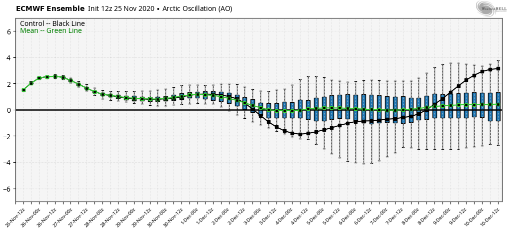
The Arctic Oscillation (AO) is a good indicator of whether the coldest air of the northern hemisphere is either tightly bottled up closer to the north pole (positive phase) or relaxed enough to spill into the lower latitudes of the northern hemisphere (negative phase). As you can see by the AO values modeled on the Euro Ensembles (courtesy of WeatherBell Analytics), we’re looking at a negative dip in the Dec 2-8 period, indicating the potential for colder air to spill into our region.
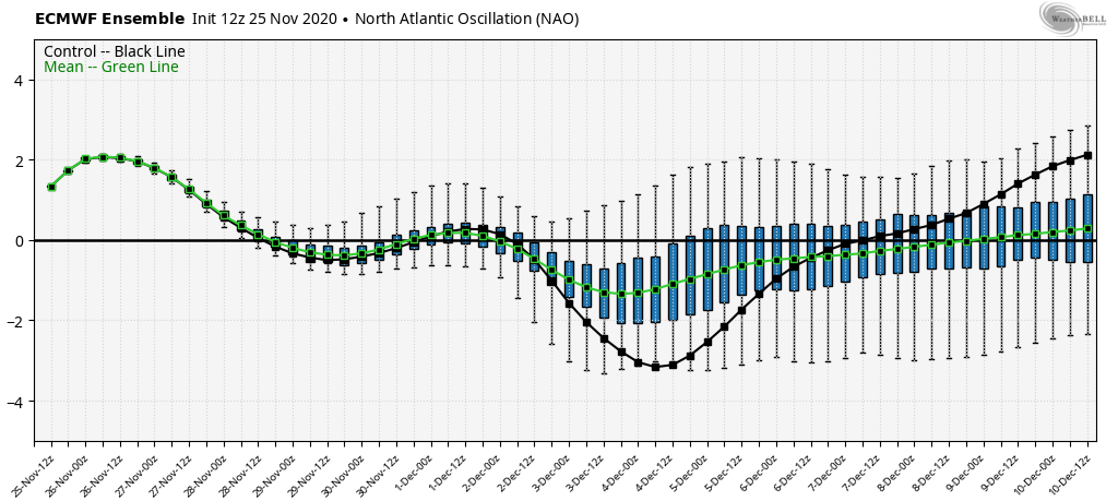
The North American Oscillation (NAO) is a good indicator of whether there is blocking over Greenland (negative phase) or not (positive phase). Blocking comes in either the form of a high pressure ridge near Greenland or sometimes a strategically positioned low in the 50N/50W location. Without blocking, the upper jet stream remains progressive, as it has been lately, and allows either low pressure disturbances or areas of high pressure to move through the NJ area, from W to E, fast…roller coaster temperatures with transient weather patterns. Blocking forces the upper jet to basically jam up just upstream of the block and dip into the lower latitudes of E North America, ultimately holding a stormier and/or colder pattern in place…a trough pattern. As you can see by the NAO values modeled on the Euro Ensembles (courtesy of WeatherBell Analytics), we’re looking at a strong dip in the Dec 2-8 period.
The Pacific North American (PNA) oscillation is a good indicator of whether there is ridging on the W side of N America (positive phase) or not (negative phase). A ridge in W N America typically means a reciprocated trough for the E US since the jet is a fixed energy stream and what happens upstream in the W US tends to happen opposite downstream for the E US. Perhaps you’ve noticed in the past that when it’s really cold in NJ during the colder season, it tends to be warmer and drier in the W US. As you can see by the PNA values modeled on the Euro Ensembles (courtesy of WeatherBell Analytics), we’re looking at a positive PNA phase through the Dec 8 period of interest.
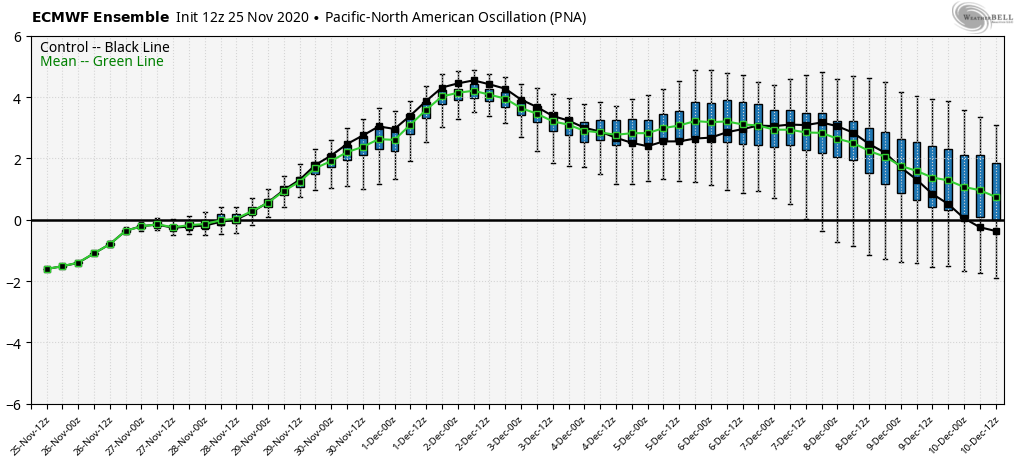
To summarize the teleconnection oscillations, it looks like there will be colder air available, adequate blocking, and W US ridging all happening at the same time to close out November and start December. Therefore this pattern supports development for a strong synoptic storm system or two in the first third of December and will be exciting to watch IMO. The Nov 30-Dec 2ish period is more certain as rain and wind with maybe some ending snow. However the Dec 5-7 period has me a bit interested. Typically when the NAO transitions from negative to positive it usually means that a strong system has just moved out of our area. With that said, are we looking at our first snow event in the Dec 5-7 period? We’ll have to monitor but the pattern would support it IMO.
Now let’s talk about some modeled physics for next week. I think the start of this dynamically wild pattern will be too warm for snow. We’re talking about the Nov 30 (this coming Monday) through Dec 3 (next Thursday) period. I think we’ll see periods of heavy rain and potentially damaging wind gusts during this time (Nov 30-Dec 2). Snow is less likely but the colder air aloft should not be underestimated. I wouldn’t see surprised to see some precip try to mix once the warm front and warm sector move through (likely by Monday night). Tuesday-Thursday will be behind this main initial slug of rain and wind but will be under the coldest air aloft.
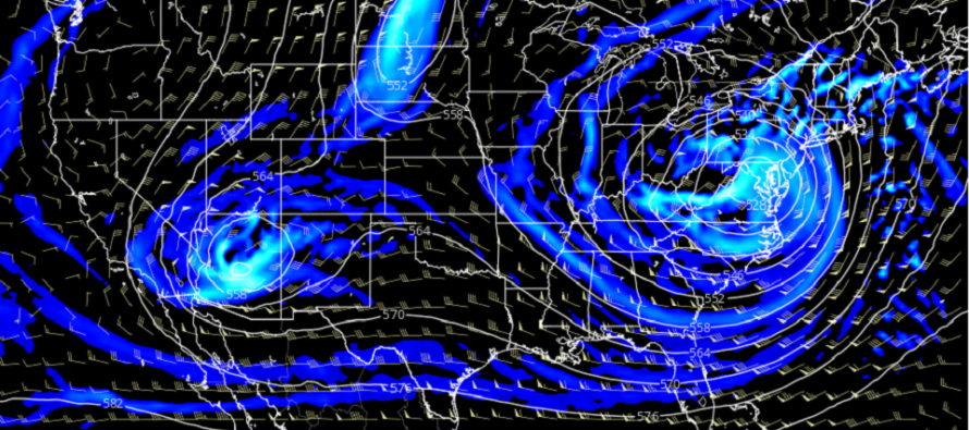
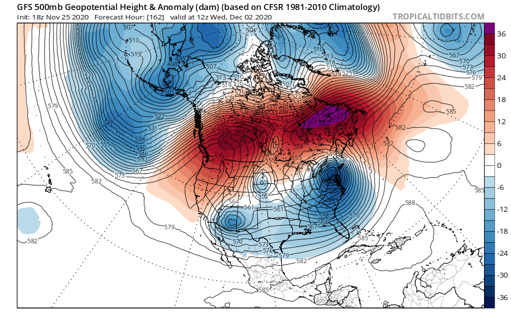
500mb geopotential height anomalies (the altitude of the 500mb pressure level compared to average) for Dec 2 indicate much colder air aloft spilling down into the E US (all the way to Florida). Notice the ridging on the W side of N America as well as the ridging just S of Greenland (the block). This is a strong synoptic storm signal IMO.
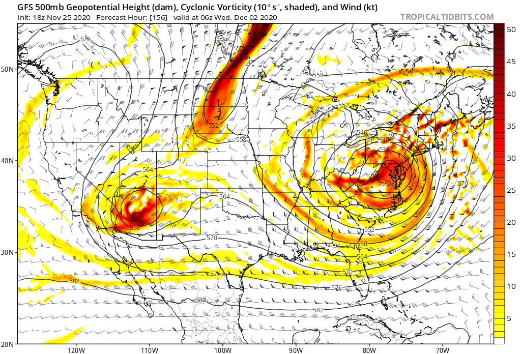
500mb cyclonic vorticity are the most impressive modeled physics for the Dec 2 period of interest. Cyclonic vorticity is a measurement of air that is either moving in a spin (yellow-orange) or moving in a straight line (white). The higher the spin and the larger the area of vorticity, the more synoptic storm energy there is.
So again, I think we’re in for some wild rain and wind this coming Monday-Tuesday with maybe the chance for some snow mixing in at the very end. No promises on that and it would only be conversational. But I then think we should keep our eye on the Dec 5-7 period for possibly some snow. The colder pattern will have been blocked in for about a week and given the trough configuration, it’s an easy environment for a low to form in the area of greatest Positive Vorticity Advection (PVA) under the area of greatest divergence and difluence on the front-side of the trough.
In English: I’m seeing some very strong atmospheric dynamics aloft for next week. At the surface this likely means heavy rain and potentially damaging winds for NJ Monday-Tuesday (Nov 30-Dec 1). The heavier rain would likely occur on Monday Nov 30. The colder air and winds in the days after. The entire period looks kind of wild though. I will continue to track this but I cannot rule out a chance of snow either when the coldest air aloft is in place over NJ or once the cold front is through in the form of lake effect streamers. Either way, this should set up some cold leading into next weekend. I’m then tracking the Dec 5-7 period as another synoptic storm signal with a better chance of being wintry. IMO, a wild start to December with a very active winter ahead. Everyone have a wonderful Thanksgiving tomorrow. I’ll check back to see how everything looks on Friday. Be safe! JC
Download the free Weather NJ mobile app on Apple and/or Android. It’s the easiest way to never miss Weather NJ content. Our premium services go even further above and beyond at the hyper-local level.
Jonathan Carr (JC) is the founder and sole operator of Weather NJ, New Jersey’s largest independent weather reporting agency. Since 2010, Jonathan has provided weather safety discussion and forecasting services for New Jersey and surrounding areas through the web and social media. Originally branded as Severe NJ Weather (before 2014), Weather NJ is proud to bring you accurate and responsible forecast discussion ahead of high-stakes weather scenarios that impact this great garden state of ours. All Weather. All New Jersey.™ Be safe! JC


LOCAL FORECAST | INTERACTIVE RADAR | LATEST NJ WEATHER ALERTS | WEDDING FORECAST| PRIVACY POLICY
© Copyright 2026 Weather NJ LLC. All Rights Reserved.
Some information that can be found on our website is provided by a private weather station and is not an officially recognized station for weather reporting. Though we always strive to achieve accurate reporting for our own use, it is important that you do NOT depend on the data provided here for any purpose.
