

Nov 26: Coastal Winter Storm Becoming Likely
Discussion: I want to real quick talk about the Thanksgiving period. Right now we’re in the developing warm sector ahead of the lakes-tracking disturbance that should bring nuisance rain only between Wednesday night and Thursday morning. The bigger story with this system are the winds. It’s a strong low and we’re likely going to feel it in the form of strong winds rocking from NW to N throughout Thursday. Gusts could easily approach/exceed 40mph making for a wind-chilled Thanksgiving. You might see the NY parade take special precautions with their balloons. Regardless the cold N flow sticks around and keeps New Jersey colder from Thursday through Saturday night/Sunday morning. And this then sets up the following three expected phases of the late-weekend coastal storm system:
Phase 1: The SW Flow. As the primary low tracks from about Arizona to the Great Lakes it will push a warm front towards NJ from the SW. Precipitation is expected to jump ahead of the warm front into the soon-departing colder conditions over New Jersey. But until the warm front arrives from the SW we’re likely looking at snow initially that changes over to a period of ice (sleet or freezing rain) and then ultimately plain rain around the time of the transfer. NNJ, especially NWNJ, has the best chance for snow accumulations in this first phase. SNJ, especially SENJ, has the least chance of snow accumulations in this first phase. Some SNJ areas might see a snowy burst but SNJ and CNJ in-general will be first to change over to rain with the surface coastal plain marine influence and lower-level warm air advection out of the SW. This first phase should occur between Saturday night and ~noon Sunday and will likely feature calmer winds during such. It starts with initial precip Saturday PM and ends with the transfer by mid-day Sunday. This phase has moderate confidence.
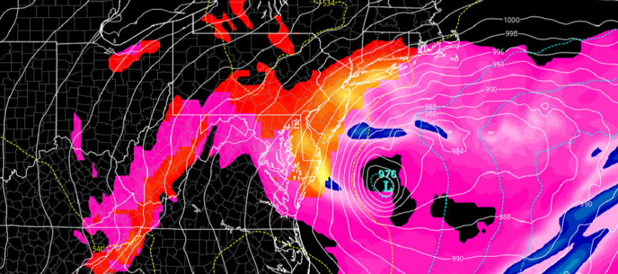
Phase 2: Coastal Storm Development. After the transfer we should have a low pressure center located just off the Delmarva/SENJ coast. This low should initiate around 990mb Sunday afternoon but could drop as low as 975mb by Monday morning—all while slowly meandering in the same general vicinity. This should hurl warmer marine air into New Jersey and change everyone over to plain rain who haven’t gone over already. Rainfall could be heavy and winds could be strong. With that said the coastal flooding risk begins in this phase. We should have some strong onshore flow pushing against NJ and Delmarva during this phase which synoptically justifies the coastal flooding concern. Astronomical tides should be okay since we’ll be closer to a first-quarter moon phase. But the draining rainfall + storm surge could do the trick. This phase should last from about noon Sunday through midnight Sunday night. It ends when temps start to crash from N to S overnight Sunday night. This phase has the most confidence of all three.
Phase 3: The Cold Conveyor Belt. When a mid-latitude cyclone forms in the traditional Norwegian Cyclone Model sense it can create an enhanced snow storm zone immediately to the N and NW of the low’s defined center. Moisture gets ramped upwards through the warms sector and then fans out W to E or sometimes SW to NE —creating an axis of heavy wintry precipitation that mimics a conveyor belt. Moisture feeds the area off the ocean and then it wraps sharply back around towards the low center. This creates the “comma head” look to the storm’s radar signature. We have confidence in this happening somewhere however we have low confidence that it will happen over NJ…for now. Some of the recent model runs suggest it happening but we are not yet ready to commit to forecasting it. Post-transfer low development is tricky business in the upper-levels regarding timing. Remember the January 2015 storm that busted because of a late development? Similar dynamics could set the specific CCB up in multiple places. It could mean the difference between the entire state seeing accumulating snow or possibly only NNJ/NENJ. Regardless this last phase would be all snow beginning when rain changes over from N to S through NJ. This phase would occur between Sunday night and about noon on Monday. Again this is currently the least confident phase of the storm given the widespread possibilities of the ending CCB location.
In English: Chances are increasing for a coastal winter storm between this Saturday night and Monday morning. It still looks like a snow to rain back to snow situation over the course of a few phases (see above for details). In a nutshell it would be snow Saturday night into Sunday morning, rain Sunday morning through Sunday night and then back to snow Sunday night through Monday morning. It is still too early for expected accumulation amounts but the event does appear more likely to occur now. Traditional climatology favors NNJ over SNJ for snow but we’ll see. My advice is to not get too wrapped-up in specific model runs. They are going to sway back and forth over the next few days (some showing more snow and others less). The meteorological concepts are far more important from this range: We have a strong primary low transferring to a strong coastal storm with available cold air to make front and back-end precipitation wintry. That should be the main takeaway for now. Snow maps will likely be issued on Thursday. Tomorrow I’ll probably do another update earlier in the day + a video at night. Have a great rest of your Tuesday and please be safe! JC
Download the new free Weather NJ mobile app on Apple and/or Android. It’s the easiest way to never miss Weather NJ content. Our premium services go even further above and beyond at the hyper-local level. Looking for industrial-caliber long-range forecasting data that I personally recommend? Check out WeatherTrends360!
Jonathan Carr (JC) is the founder and sole operator of Weather NJ, New Jersey’s largest independent weather reporting agency. Since 2010, Jonathan has provided weather safety discussion and forecasting services for New Jersey and surrounding areas through the web and social media. Originally branded as Severe NJ Weather (before 2014), Weather NJ is proud to bring you accurate and responsible forecast discussion ahead of high-stakes weather scenarios that impact this great garden state of ours. All Weather. All New Jersey.™ Be safe! JC


LOCAL FORECAST | INTERACTIVE RADAR | LATEST NJ WEATHER ALERTS | WEDDING FORECAST| PRIVACY POLICY
© Copyright 2026 Weather NJ LLC. All Rights Reserved.
Some information that can be found on our website is provided by a private weather station and is not an officially recognized station for weather reporting. Though we always strive to achieve accurate reporting for our own use, it is important that you do NOT depend on the data provided here for any purpose.
