

Nov 29: Coastal Wintry Storm a Go
Discussion: I hope you all had a wonderful Thanksgiving. It is now time to take the Sunday-Monday coastal storm setup seriously. We are well within the mid-range forecasting period with strong agreement on model guidance, a favorable pattern and matching live observations. As I’ve been doing in prior articles let’s break down the storm impacts into the following phases:
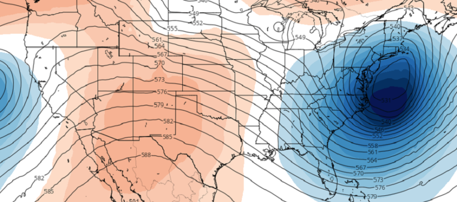
Phase 1: The SW Flow. Our primary low is already affecting the W US, specifically the AZ elevations, and will continue towards the Great Lakes. We expect that low to arrive at the Great Lakes by early Sunday AM which should push a warm front into New Jersey around the same time. Precipitation is expected to jump the warm front (overrunning precip) and start areas along and NW of the NJ Turnpike/I-95 corridor with snow and ice. Areas SE of the NJ Turnpike/I-95 are primarily looking at rain to start. Areas closer to the NJ Turnpike have the best chance to briefly start as snow or ice. NNJ/NWNJ have the best chance to see the most front-end snow in this phase. Said areas also have the best chance to remain wintry. Lower NJ elevations still NW of the NJ Turnpike (NENJ and WCNJ) should see more ice in the form of sleet and/or freezing rain. The ice threat is actually looking significant. High pressure and blocking to the NE will be responsible for initiating the transfer and holding colder air in at the surface despite the warm air advection in the low-mid levels. This phase starts during the early AM hours of Sunday and completes with the low transfer by Sunday afternoon. We are fairly confident in this first phase. The following maps address wintry impacts for this first phase only. The first map is for Snow and Sleet (initial precip type). The second map is for freezing rain (aka ZR) which occurs after the snow and sleet changeover.
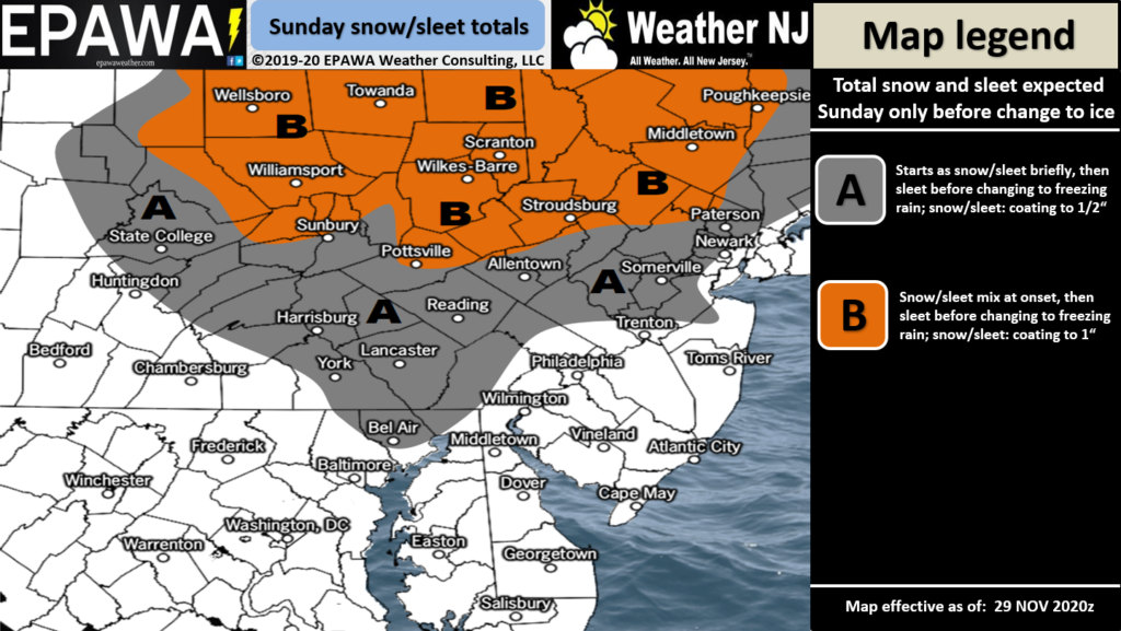
Click here to view full resolution Snow/Sleet Map!
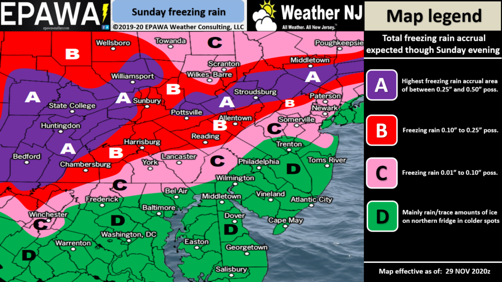
Click here to view full resolution Freezing Rain Map!
Phase 2: Coastal Storm Development. By late-Sunday afternoon the low should be transferred from the Great Lakes to just off the coast of New Jersey. This low positioning will torch most of New Jersey with warmer marine air (too warm for snow). Only extreme NNJ/NWNJ have a chance to hold onto temperatures cold enough for wintry precipitation. Most of New Jersey will be too warm and will experience periods of rainfall. Since the low is expected to be offshore of New Jersey not Delmarva the coastal flooding threat is somewhat mitigated. Most winds for coastal areas will be out of the NE or N/NE (far from parallel to the inlets). With that said let’s allow for minor level coastal flooding from just having a strong storm offshore. Precipitation could shut off by Sunday evening giving us a lull into Monday morning. Winds would likely sustain however given proximity to the coastal low. This second phase is expected to occur between Sunday afternoon and Monday morning. We are extremely confident in this phase.
Phase 3: The Cold Conveyor Belt (CCB). The last phase is what most are concerned about and with good reason. As the secondary coastal low pulls away it will be dragged backwards, towards New Jersey, by the Upper-Level Low (ULL). This interaction is expected to produce an axis of moderate-to-heavy snowfall under the CCB that should be wrapping around from the N/NE. 700mb and above are frigid (more than cold enough to support snow). 850mb and below are somewhat warm from two reasons: 1) the decaying warm sector of the primary low (pre-transfer) and 2) Marine influence from the secondary low’s easterly fetch. Heavy precipitation and the intensity of the low interaction however could pull the colder air to the surface. For this reason phase 3 holds the highest uncertainty. We are fairly confident in CCB snow for NEPA and NWNJ. We have low confidence however that the heavier snow makes it down to I-195 or below. I-80 and N are most favored for the jackpot. Between I-80 and I-78 are favored for lesser snowfall but still possibly disruptive and plowable. We think that I-195 should be the southern-most extent of trace-to-light snow accumulations. Everyone S of I-195 are likely looking at rain ending as snow with little-to-no accumulations. So NNJ is favored for this third and final snowy phase. SNJ snow lovers will likely be found wanting. SNJ snow haters will likely rejoice. And that’s with NNJ/SNJ divided at I-195. This third phase should occur between Monday morning and Monday night. We might even see some wraparound snow linger into early Tuesday AM. The following map indicates our best guess at snow probabilities for this last phase:
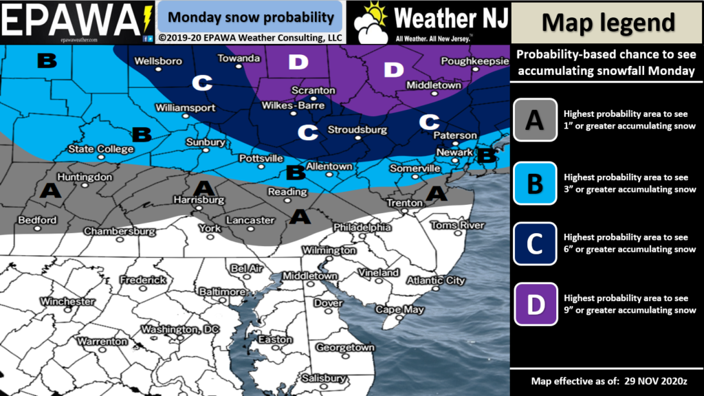
Click here to view full-resolution Snow Map!
Wildcard Potential: This will not be an event where widespread snow peppers the entire coverage region with snow. The third phase CCB is going to puke snow and therefore if extends as far inland and S as Philadelphia then NNJ and CNJ could both jackpot. On the other end of that spectrum is the CCB setting up too far E or NE which would mean only extreme NNJ and areas NE of such (New England) jackpot. It all comes down to ULL timing and level of interaction. Our above maps assume the middle of the road. Just know that there is high volatility with such cold and strong dynamics aloft.
In English: Expect generally cold conditions this weekend with N flow. On Sunday morning precipitation will approach early from the SW and impact NJ through Sunday afternoon. Likely snow to ice to rain NW of the turnpike and rain SE of the turnpike (possibly a very brief changeover). See the first two maps above for front-end wintry impacts of this system. The NWNJ icing is likely the most dangerous aspect of the first half of the system. We then see a milder lull in precipitation Sunday night into Monday morning but with some stronger winds around. Extreme NNJ/NWNJ might remain wintry/cold. Then Monday late-morning through late Monday night (possibly into the early AM hours of Tuesday now) should be the main wintry event primarily N of I-195 in New Jersey. We’re talking plowable and disruptive snow for Monday PM hours…at least for NNJ possibly for parts of CNJ too. SNJ likely escaping most wintry impacts from this entire system aside from front and back-side snowfall possible (little-to-no accums). Regardless there are many opportunities for power outages and downed tree branches from additional weight of snow/ice winds so please be careful! That’s how it all looks as of right now. Have a great rest of your Friday and please be safe! JC
Download the new free Weather NJ mobile app on Apple and/or Android. It’s the easiest way to never miss Weather NJ content. Our premium services go even further above and beyond at the hyper-local level. Looking for industrial-caliber long-range forecasting data that I personally recommend? Check out WeatherTrends360! Visit the Weather NJ Kaboom Shop for hoodies, tees and infant onesies.
Jonathan Carr (JC) is the founder and sole operator of Weather NJ, New Jersey’s largest independent weather reporting agency. Since 2010, Jonathan has provided weather safety discussion and forecasting services for New Jersey and surrounding areas through the web and social media. Originally branded as Severe NJ Weather (before 2014), Weather NJ is proud to bring you accurate and responsible forecast discussion ahead of high-stakes weather scenarios that impact this great garden state of ours. All Weather. All New Jersey.™ Be safe! JC


LOCAL FORECAST | INTERACTIVE RADAR | LATEST NJ WEATHER ALERTS | WEDDING FORECAST| PRIVACY POLICY
© Copyright 2026 Weather NJ LLC. All Rights Reserved.
Some information that can be found on our website is provided by a private weather station and is not an officially recognized station for weather reporting. Though we always strive to achieve accurate reporting for our own use, it is important that you do NOT depend on the data provided here for any purpose.
