

Nov 29: Rain and Wind Approaching
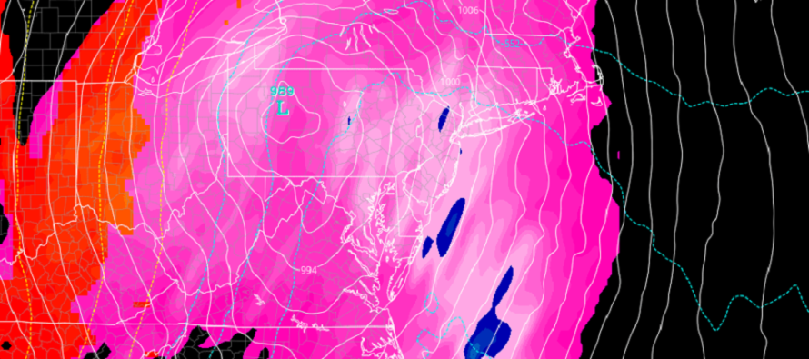
Discussion: Two upper level disturbances, from separate N and S jet streams, are combining into a single energy vort to our W in the central US. I still see this as a pattern changer. The first of many surface lows should track from the N Gulf of Mexico up through the interior E US between now and early Tuesday AM. The actual low should pass over central PA when at NJ latitude. This puts NJ on the warm side of the system but still poses a threat for heavy rainfall and damaging wind gusts on Monday, especially Monday morning.
Precipitation should begin by sunrise on Monday for SNJ in the form of a warm front with a SE fetch off the ocean. By 9am, the main slug of precipitation should spread into the rest of NJ from SW to NE and persist until at least noon statewide. From noon through about 2-3pm or so, the main slug of precipitation should taper off, also from SW to NE. A few isolated remnant pockets of rain could linger until late-afternoon/early-evening but again, the heaviest stuff should fall between sunrise and noon. In general, rainfall amounts of .5” to .75” should be expected with 1-2” possible wherever the heavier bands hold longest. These areas are impossible to determine until the 11th hour and will likely be where any thunderstorm action happens. The cold front will come much later than the rain ending. It might be Tuesday morning before it pushes through all of NJ which will setup a colder Tuesday and Wednesday.
As far as wind goes, it’s a sub-990mb low moving through PA from S to N. That’s going to howl out of the SE for NJ. Extreme SNJ/SENJ coastal regions should feel this most with gusts of 40-60mph possible. Once you get further downwind (over land) in NJ, geographic friction should knock down the wind gusts to maybe just 20-40mph. Sustained values obviously lower. NWNJ should feel the least amount of wind while extreme SNJ/SENJ feels the most. Winds should gradually pick up between now and sunrise, then peak from about 8am to 8pm. Wind direction should gradually rock from E/SE to S/SE in that period.
Minor levels of coastal flooding are possible for immediate SNJ/SENJ coastal regions (ocean-facing and along bays). Normally a quick mover like this would have negligible coastal flooding implications. However, with the full moon tomorrow (Monday), tidal levels could become slightly uncomfortable for the high tide just before noon. I don’t think we’re looking at destructive flooding but more like water in the streets in the places that traditionally see water in the streets. That first high tide on Monday, just before noon, aligns closest with the period of SE wind-driven storm surge. The evening high tide should see much lower levels with no tidal flooding concerns remaining.
Once this system moves up into Canada by late-Tuesday morning, a strong trough will settle over the Mid-Atlantic and NorthEast US…very cold air aloft despite only a slightly cold surface. It will be interesting to see if any lake effect snow bands or snow squalls make it into NJ. NWNJ would have the best chance to see them. The main driver of this would be the strong cyclonic vorticity of the upper-level low and the very low geopotential height anomalies. Additionally, the not-as-cold surface under the much colder air aloft could enhance lifting convectively. It won’t take much lifting for a parcel to reach saturation in a below-freezing environment. A fun bonus to watch out for. My eyes are still glued to the Dec 5-7 period and slightly beyond as the slightly -NAO/-AO/+PNA pattern establishes after these wild upper level dynamics (tomorrow-Dec 3) change the pattern.
In English: Heavy rain and wind should move in by sunrise Monday morning and spread into all of NJ by noon. During this period, winds could become very gusty especially for coastal SNJ/SENJ areas. Thunderstorms are possible within the heaviest rainfall. Rain should then end from SWNJ to NENJ between noon and 3pm with isolated showers still possible until sunset. Winds could remain gusty out of the SE a bit further into the evening before subsiding overnight to just breezy. Minor coastal flooding is possible Monday morning particularly for the high tide occurring just before noon…with a full moon. Tuesday and Wednesday then look colder. For more details about the rest of the week, please see the Monday-Friday outlook. Still eyeing up this weekend for a potential wintry system. Be safe! JC
Download the free Weather NJ mobile app on Apple or Android. It’s the easiest way to never miss Weather NJ content. Our premium services go even further above and beyond at the hyper-local level. Get your merch on at the KABOOM shop in time for the holidays.
Jonathan Carr (JC) is the founder and sole operator of Weather NJ, New Jersey’s largest independent weather reporting agency. Since 2010, Jonathan has provided weather safety discussion and forecasting services for New Jersey and surrounding areas through the web and social media. Originally branded as Severe NJ Weather (before 2014), Weather NJ is proud to bring you accurate and responsible forecast discussion ahead of high-stakes weather scenarios that impact this great garden state of ours. All Weather. All New Jersey.™ Be safe! JC


LOCAL FORECAST | INTERACTIVE RADAR | LATEST NJ WEATHER ALERTS | WEDDING FORECAST| PRIVACY POLICY
© Copyright 2026 Weather NJ LLC. All Rights Reserved.
Some information that can be found on our website is provided by a private weather station and is not an officially recognized station for weather reporting. Though we always strive to achieve accurate reporting for our own use, it is important that you do NOT depend on the data provided here for any purpose.
