

Nov 30: Tornado Watch Discussion
Discussion: The heaviest precipitation slug has passed through New Jersey from S/SW to N/NE. Some of those downpours were intense. I know because I was in one. Remaining precipitation today will be of an isolated-to-scattered nature, no longer widespread.
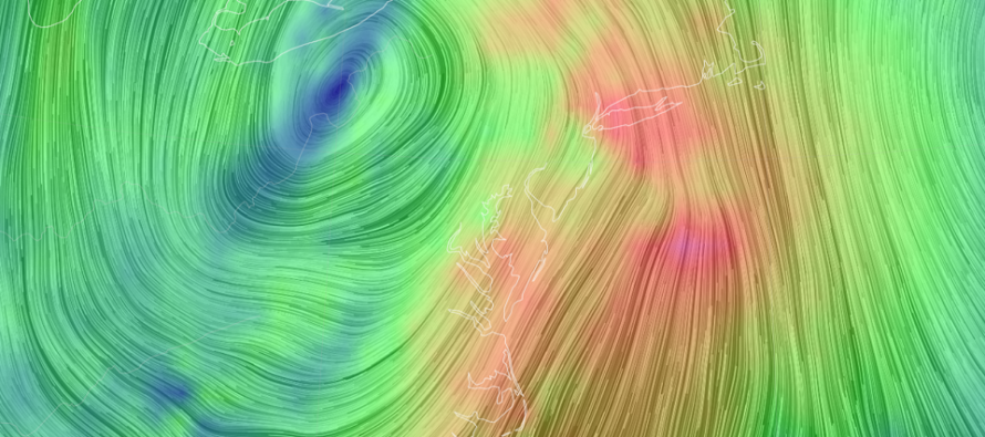
We now shift our attention to some of the wild dynamics that I mentioned in my discussion last week. The surface low is currently over W/C PA and tracking to the N/NE. All surface level air flow is racing towards the center of this low in a cyclonic flow. This puts the strong surface flow over NJ out of the SE.
The mid and upper level flow however (850mb and above) are all in alignment with the mid and upper level lows that are forming the approaching upper level low/trough. That means that from about 5,000 feet and up, the flow is out of the SW.
Therefore, we have SE flow at the surface underneath SW flow aloft which is obviously producing a difference in wind direction over altitude (vertical wind shear). That should create several areas of horizontal roll in the atmosphere. If convective currents (downdraft from rainfall/updraft from correlating lifting) can turn the horizontal roll into a vertical structure then a tornado would form and touchdown. This is likely what the National Weather Service is seeing and the reason why they have issued a tornado watch until 7pm today for portions of NJ, with the greatest chance in SNJ.
While the tornado watch is justified in expressing a small possibility of such happening for safety awareness, it is not a guarantee. Such an occurrence would likely be very isolated. I do recommend keeping your finger on the pulse of your favorite weather source just in case.
In English: The widespread rain is over. Isolated, perhaps scattered, pockets of rain should remain until ~sunset today. Winds should continue to whip with a small chance of an isolated tornado in this period. This will all end around or just after sunset this evening and we’ll be left with stiff, cold, but stable and aligned W, maybe W/NW, winds to chill us down for the next few days. Have a great rest of your Monday and please be safe! JC
Download the free Weather NJ mobile app on Apple or Android. It’s the easiest way to never miss Weather NJ content. Our premium services go even further above and beyond at the hyper-local level. Get your merch on at the KABOOM shop in time for the holidays.
Jonathan Carr (JC) is the founder and sole operator of Weather NJ, New Jersey’s largest independent weather reporting agency. Since 2010, Jonathan has provided weather safety discussion and forecasting services for New Jersey and surrounding areas through the web and social media. Originally branded as Severe NJ Weather (before 2014), Weather NJ is proud to bring you accurate and responsible forecast discussion ahead of high-stakes weather scenarios that impact this great garden state of ours. All Weather. All New Jersey.™ Be safe! JC


LOCAL FORECAST | INTERACTIVE RADAR | LATEST NJ WEATHER ALERTS | WEDDING FORECAST| PRIVACY POLICY
© Copyright 2026 Weather NJ LLC. All Rights Reserved.
Some information that can be found on our website is provided by a private weather station and is not an officially recognized station for weather reporting. Though we always strive to achieve accurate reporting for our own use, it is important that you do NOT depend on the data provided here for any purpose.
