

Nov 30: Wintry Storm Approaching
Discussion: Let’s break the 3 phases we’ve been discussing into the following timing expectations:
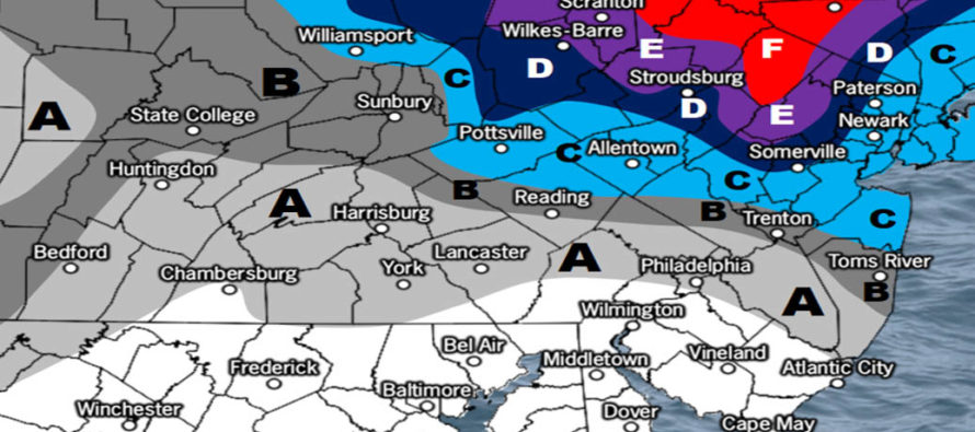
Phase 1: Sunday Morning through Sunday afternoon. The warm front will arrive from the SW with precipitation after midnight tonight (Saturday night). I expect precip to be widespread through New Jersey by late-Sunday morning. High pressure located to our NE will be pumping cold air in at the surface (out of the NW) as the warm front advects overhead in the low-mid levels from the SW. This creates an environment favorable for snow changing to sleet first and then to freezing rain for areas just along and NW of the I-95 corridor (NJ Turnpike). Areas SE of I-95 could see a little wintry precipitation at first but should quickly change over to plain rain. Coastal SENJ will likely start and remain plain rain. The following two impact maps are for this first phase only and are considered final calls for Sunday.
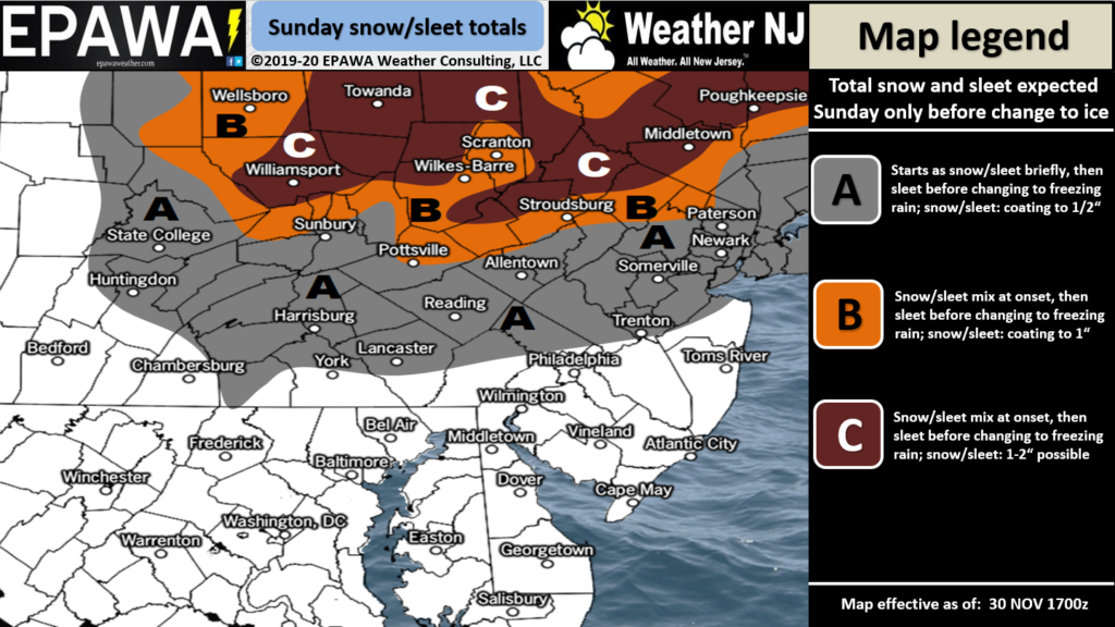
Click here to view full-resolution map.
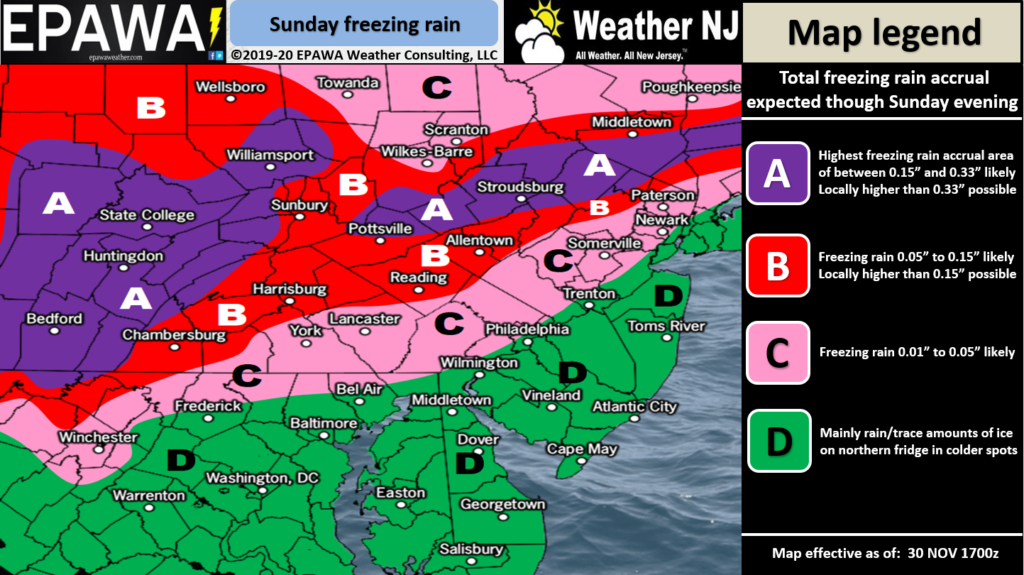
Click here to view full-resolution map.
Phase 2: Sunday evening through Monday morning. Once precip has moved in and warmed with the warm front, most of New Jersey should change to all plain rain for this middle phase. The low will be transferring to just off the coast of New Jersey during this time. Winds should pick up but coastal flooding risks should be capped at minor given the expected low’s location and coastal wind direction influence. NWNJ (N of I-80/NW of I-287) has the best chance to remain wintry even for this warmer middle phase. Precip type is uncertain however given the volatility in low-mid level temperatures. If all cold then it will be all snow. If a warmer wedge of air noses in between 850-700mb then either sleet or freezing rain would be the type. All rain for lower 2/3 of NJ though. We’ll likely see at least some form of lull in precipitation between Sunday PM and Monday morning but precip should then return for the final phase.
Phase 3: Monday afternoon through early-Tuesday AM. As the coastal low pulls away out to sea it will interact with the Upper-Level Low (ULL) that the former primary surface low came in under. This interaction is expected to bring a Cold Conveyor Belt (CCB) into the region from the NE. This CCB will be an area of moderate-to-heavy back-end snowfall wrapping around the top of the elongated ULL-coastal low axis of lower pressure. We still think that NNJ benefits most from this snowfall-wise (along and N of I-80). The following snow map is for the rain back to snow scenario that should start by late Monday morning and end just after midnight Tuesday AM. This is not a final call like the two maps above for tomorrow. We’ll make a final call on Monday snow tomorrow. For now here is the latest for this final phase:
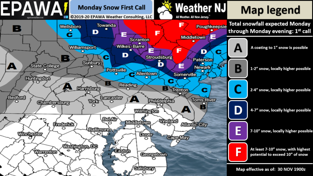
Click here to view full-resolution map.
In English: Snow and ice arrive NW of the turnpike tomorrow morning (rain SE of the turnpike). Most areas go over to all rain except for NWNJ. Then everything changes back to snow on Monday with disruptive/plowable accumulations likely for at least NNJ and some parts of CNJ. SNJ could end with snowfall but little-to-no accumulations likely. It is safe to say I’m watching at least Sussex County (possibly N Warren, N Morris and NW Pasaic) for Kaboom potential if snow performs on the higher side of the expected range. Please see the above maps for more detail. Everyone have a great Saturday night and please be safe! JC
Download the new free Weather NJ mobile app on Apple and/or Android. It’s the easiest way to never miss Weather NJ content. Our premium services go even further above and beyond at the hyper-local level. Looking for industrial-caliber long-range forecasting data that I personally recommend? Check out WeatherTrends360! Visit the Weather NJ Kaboom Shop for hoodies, tees and infant onesies.
Jonathan Carr (JC) is the founder and sole operator of Weather NJ, New Jersey’s largest independent weather reporting agency. Since 2010, Jonathan has provided weather safety discussion and forecasting services for New Jersey and surrounding areas through the web and social media. Originally branded as Severe NJ Weather (before 2014), Weather NJ is proud to bring you accurate and responsible forecast discussion ahead of high-stakes weather scenarios that impact this great garden state of ours. All Weather. All New Jersey.™ Be safe! JC


LOCAL FORECAST | INTERACTIVE RADAR | LATEST NJ WEATHER ALERTS | WEDDING FORECAST| PRIVACY POLICY
© Copyright 2026 Weather NJ LLC. All Rights Reserved.
Some information that can be found on our website is provided by a private weather station and is not an officially recognized station for weather reporting. Though we always strive to achieve accurate reporting for our own use, it is important that you do NOT depend on the data provided here for any purpose.
