

Nov 5: Watching Thursday Night
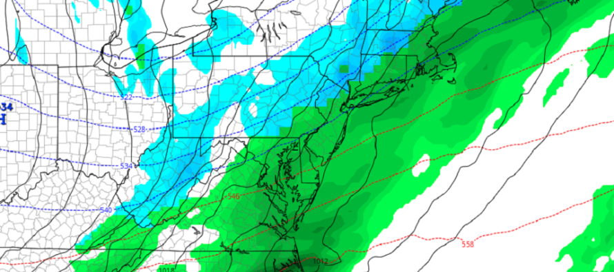
Discussion: An Arctic high is currently dropping out of Canada into the US near the Montana/North Dakota area. This high is expected to track E/SE, to the S of the Great Lakes and depart into the Atlantic Ocean somewhere in the Mid-Atlantic US (OBX<->Delmarva). This high is pulling an Arctic air mass southward ahead of it. The front of that cold air mass is considered an Arctic front. If this was January it would likely produce dangerous levels of cold. We’re in November now so it won’t be as cold as January but it will still be very cold seasonably.
The Arctic front should eventually pass over NJ from NW to SE. We then have a low pressure disturbance/wave originating in Mexico/Texas that will also track towards the Mid-Atlantic US along the Arctic frontal boundary. This should bring a period of rain for most of New Jersey between Thursday night and Friday morning. Once the rain stops the Arctic frontal boundary should then pass through bringing the colder air to NJ for the weekend.
For most of New Jersey this is a simple “rain ahead of the cold” situation. The rain will end before the cold air arrives—removing the possibility of snow. I’d say this is the probable outcome for all of NJ except the elevations of Sussex County. For areas like High Point Monument and near surroundings the temperatures could drop into the snow range before precipitation ends. Said areas have elevation, dynamics and orographic lifting on their side to end wintry. The models are not enthused about this and show mostly an all-rain situation for all of NJ even upper Sussex. I just know better from past experience to write off the wintry-ending potential for the High Point Monument area I am talking about.
Therefore most NJ counties should expect an all-rain solution this Thursday evening through Friday morning. Upper Sussex however (near High Point Monument and nearly-surrounding areas) has the potential to end with rain changing to snow. Anything from “just rain ending as non-accumulating snow” to trace/light snow accumulations would be possible.
We’re not dealing with a significant snow storm here. If the Arctic front were to speed up and move into more of the rainfall earlier then possibly more of NNJ could see a wintry finish. We’re not currently there though. Just a wildcard consideration for expectations. And if the Arctic front is slower then we might be wasting our time talking about snow anywhere in NJ. But based on the latest guidance starting to get a handle on the timing, this is how it currently looks.
Regardless of how much snow possibly falls and stacks up for upper-Sussex, we will likely have below-freezing temperatures moving in behind rainfall. This is a recipe for icy roads overnight into Friday AM’s rush hour commute. I would say it could be more of an issue NW of the turnpike than SE of such. We’ll have stiff dry northerly winds which should help to evaporate most main roads. Side roads, puddles, etc. should be cautiously approached in the interest of weather safety awareness however (driving/walking/etc.).
Temperatures should then drop like whoa for Friday through Sunday morning. We should then moderate back to near-average temperatures Sunday-Tuesday ahead of the Nov 13-15 storm signal that is still very much alive. I’ll need to get through this Thursday-Friday system before properly assessing that signal.
In English: Expect a rainy period between Thursday evening and Friday morning. All of NJ except for the higher NWNJ elevations (1200 feet and above) should expect all rain from start to finish. Said NWNJ elevations could be looking at a snowy finish in the early Friday AM hours but nothing too crazy. Temps then take a noticeable drop for Friday and Saturday. Be careful Friday AM in case there are any frozen puddles or road areas leftover from the pre-cold rain.
Download the new free Weather NJ mobile app on Apple and/or Android. It’s the easiest way to never miss Weather NJ content. Our premium services go even further above and beyond at the hyper-local level. Looking for industrial-caliber long-range forecasting data that I personally recommend? Check out WeatherTrends360!
Jonathan Carr (JC) is the founder and sole operator of Weather NJ, New Jersey’s largest independent weather reporting agency. Since 2010, Jonathan has provided weather safety discussion and forecasting services for New Jersey and surrounding areas through the web and social media. Originally branded as Severe NJ Weather (before 2014), Weather NJ is proud to bring you accurate and responsible forecast discussion ahead of high-stakes weather scenarios that impact this great garden state of ours. All Weather. All New Jersey.™ Be safe! JC


LOCAL FORECAST | INTERACTIVE RADAR | LATEST NJ WEATHER ALERTS | WEDDING FORECAST| PRIVACY POLICY
© Copyright 2026 Weather NJ LLC. All Rights Reserved.
Some information that can be found on our website is provided by a private weather station and is not an officially recognized station for weather reporting. Though we always strive to achieve accurate reporting for our own use, it is important that you do NOT depend on the data provided here for any purpose.
