

Nov 6: Rain Ends as Snow for Some
Discussion: A strong area of high pressure is diving down out of Canada into the US near North Dakota/Montana. This high will track S of the Great Lakes and into the Atlantic Ocean S of New Jersey. That puts the entire state of New Jersey on the front-side of the high’s anti-cyclonic flow which ultimately means a cold Arctic injection of air mass (for Friday and Saturday).
Conditions ahead of the Arctic cold front however are expected to be mild through Thursday evening. We still have some above-average geopotential heights clearing out of the NJ area with a strong SW flow. For this reason it could hit or slightly exceed 60 degrees in many places for Thursday high temperatures.
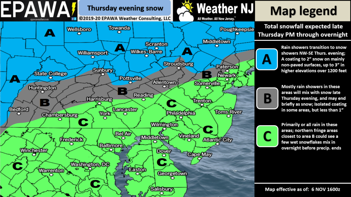
Regardless we have a wave of low pressure traversing the approaching Arctic frontal boundary (approaching from the SW along the front) and that will be the source of our precipitation from Thursday evening into early Friday morning. I expect most of this precipitation to start as and stay all-rain for most of New Jersey especially CNJ and SNJ. NNJ however, especially the NWNJ elevations, have the chance to end with wintry-type precipitation for a few reasons.
One, the NWNJ elevations are the closest part of NJ to the Arctic cold front approaching from the NW. Two, the NWNJ elevations are colder than sea level NJ locations. As you increase altitude in the troposphere you decrease in temperatures. Areas above 1200 feet will therefore have a colder advantage in possibly ending as snow. Lastly, there are a few dynamic principals like orographic lifting which can enhance precipitation for mountainous regions and help bring down some of the colder air aloft.
Look this is not a big deal and I don’t mean to beat it to death. But NWNJ elevations have a good chance to end with rain changing to snow and a small chance of accumulations. Our snow map below represents our best evidence-based call based on comprehensive model data and real-time observations.
Once the precipitation shuts off (early Friday AM) the Arctic front should plunge SE-ward through the entire state of New Jersey dropping many areas below-freezing. Keep this in mind for any rainfall that hasn’t yet evaporated. We’ll have some stiff NW winds on Friday which should help dry out most roads especially after sunrise. But for those who commute between 3-6am please treat anything wet as frozen for safety awareness purposes especially if temperatures are still below-freezing. I see this being much more of an issue NW of the turnpike. SE of the turnpike should likely be fine. Again though please use some common sense. If it’s below freezing and it looks wet treat it as ice. There will likely be little-to-no road treatments and if there are they will likely be washed out by the rain.
Friday and Saturday they look very anonymously cold for this time of year. Parts of NNJ might not escape the 30s for high temperatures. The rest of NJ might not escape the 40s for high temperatures even the SENJ coast. Overnight lows temperatures will likely fall below freezing for many areas away from the ocean. By Sunday we moderate some.
Many of you are seeing models flying around on social media about next Tuesday-Wednesday. This is the strong mid-November winter storm signal that I first mentioned in the Nov 1 WeatherTrends360 November outlook. The signal is still there and looks colder than this more-immediate Thursday night system. I will begin taking next week’s system seriously if the signal is still screaming on Friday. Need to get through the current system first.
In English: Thursday is going to feel mild with many areas approaching/breaking 60. Rain moves in by Thursday evening and stops by Friday morning. NENJ, CNJ and SNJ should expect mostly rain with possibly a few ending snowflakes that fail to accumulate (closer to the turnpike and I-78/I-80). NWNJ could end with a wintry scene as our snow map below outlines. Tomorrow we’ll make any necessary adjustments as the closer approaches. Have a great Wednesday evening and please be safe! JC
Trouble seeing the snow map?
Click here for full-resolution!
Download the new free Weather NJ mobile app on Apple and/or Android. It’s the easiest way to never miss Weather NJ content. Our premium services go even further above and beyond at the hyper-local level. Looking for industrial-caliber long-range forecasting data that I personally recommend? Check out WeatherTrends360!
Jonathan Carr (JC) is the founder and sole operator of Weather NJ, New Jersey’s largest independent weather reporting agency. Since 2010, Jonathan has provided weather safety discussion and forecasting services for New Jersey and surrounding areas through the web and social media. Originally branded as Severe NJ Weather (before 2014), Weather NJ is proud to bring you accurate and responsible forecast discussion ahead of high-stakes weather scenarios that impact this great garden state of ours. All Weather. All New Jersey.™ Be safe! JC


LOCAL FORECAST | INTERACTIVE RADAR | LATEST NJ WEATHER ALERTS | WEDDING FORECAST| PRIVACY POLICY
© Copyright 2026 Weather NJ LLC. All Rights Reserved.
Some information that can be found on our website is provided by a private weather station and is not an officially recognized station for weather reporting. Though we always strive to achieve accurate reporting for our own use, it is important that you do NOT depend on the data provided here for any purpose.
