

Nuisance Coastal Low Passes By
Discussion: Today’s conditions I actually find relaxing and enjoyable, so long as we’re not in the middle of a rainy pattern. Onshore flow and rain this time of year have a unique feel that I’ve grown to like over my lifetime. It’s likely because of the warmer ocean temperatures (72+) pushed onshore into cooler land temperatures (60-65). It’s a warmer, almost comforting, feeling to experience the raw marine flow IMO. Much different than when the marine flow is colder than the air (much of the year). Anyway, that’s my weatherfeelz rant…a cloudy rainy onshore day in Sept is not so bad when it’s nested between immaculate conditions…and that’s what we return to for Thursday into the weekend after such a great start earlier this week.
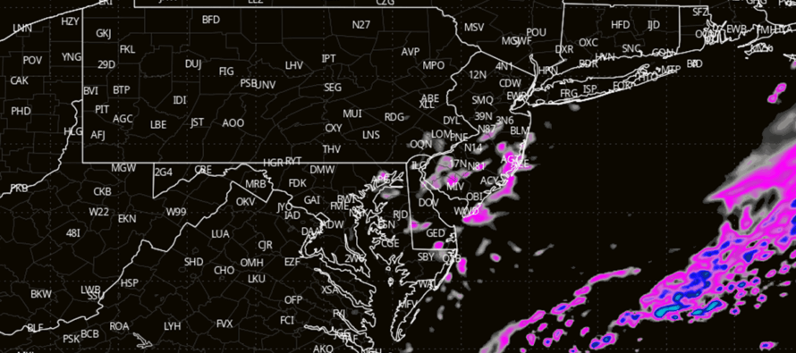
Today’s rain is associated with a coastal low a few hundred miles offshore. Stronger winds and heavier rain exist closer to the core (out in the ocean) but for NJ, only the outer bands are affecting us with mostly nuisance conditions. I wouldn’t get excited about significant levels of rainfall. I’d be surprised if anyone even cracks into the quarter-to-half inch of rain category, even right along the coast. Otherwise, it’s nuisance rain pushed into NJ to about the I-95/NJTP corridor with just sprinkles immediately NW of that. Rain should dry out and end from NW to SE between 4-8pm.
I’m seeing wind gusts just over 30mph along the SENJ coast, mostly from a NE or N/NE wind direction. This wind direction is kinder to the shore regarding coastal flooding so only minor levels of that are expected. Otherwise, the surf is enhanced/choppy (7ft @ 8 seconds) with hazardous rip currents. For any late-season beachgoers/swimmers, not a bad day to stay out of the ocean. Marine conditions should subside by late Thursday morning.
Thursday, Friday and Saturday looks very nice. Low humidity should drive a pleasant feel even though temperatures could reach over 80 Thursday (“it’s a dry heat lol”). Friday is back to the lower-70s and Saturday the mid-70s…again all nice and mostly clear…warm pleasant days and cool (just above crisp) nights. Sunday’s forecast is evolving into a rainy day as a C US ridge blocks the jet up and sends an upper low to NJ from due N. This upper-level disturbance should drive some rain into NJ for Sunday but also another round of below-average temperatures until that ridge can drift E. And even then, the ridge is modeled to flex hardest up in SE Canada leaving NJ on more of the zonal side of things. The cooler and mostly dry pattern should at least continue into next week (at least through about Sept 17).
In English: Nuisance rain and breeze are around today with some rough, but not horrible, ocean conditions…thanks to a weak coastal disturbance offshore. The pattern snaps back to dry and pleasant Thursday-Saturday (Thursday the warmest). Sunday now looking a bit rainy to set up a cooler start to next week. I’ll have the weekend outlook posted Friday but wanted to update you on today’s coastal. Be safe! JC
Premium Services
KABOOM Club offers ad-free content, inside info forecast discussion, your questions answered, and early storm impact maps and video releases (ahead of the public). At $1.99 per month, it’s an extremely feasible way to show additional support for Weather NJ and you can can turn it on and off for however many months you wish. Think of it as a tip jar with perks. The public eventually sees all info discussed in premium areas. Available onFacebook or Patreon.
My Pocket Meteorologist (MPM), in partnership with EPAWA Weather Consulting, offers professional/commercial interests, whose businesses depend on outdoor weather conditions (snow plowing, landscaping, construction, etc.), with hyper-local text message alerts/forecasts and access to the MPM premium forum—the most comprehensive and technical forecast discussion available for PA and NJ.
Jonathan Carr (JC) is the founder and sole operator of Weather NJ, New Jersey’s largest independent weather reporting agency. Since 2010, Jonathan has provided weather safety discussion and forecasting services for New Jersey and surrounding areas through the web and social media. Originally branded as Severe NJ Weather (before 2014), Weather NJ is proud to bring you accurate and responsible forecast discussion ahead of high-stakes weather scenarios that impact this great garden state of ours. All Weather. All New Jersey.™ Be safe! JC


LOCAL FORECAST | INTERACTIVE RADAR | LATEST NJ WEATHER ALERTS | WEDDING FORECAST| PRIVACY POLICY
© Copyright 2025 Weather NJ LLC. All Rights Reserved.
Some information that can be found on our website is provided by a private weather station and is not an officially recognized station for weather reporting. Though we always strive to achieve accurate reporting for our own use, it is important that you do NOT depend on the data provided here for any purpose.
