

Oct 11: Michael Remnants Approaching
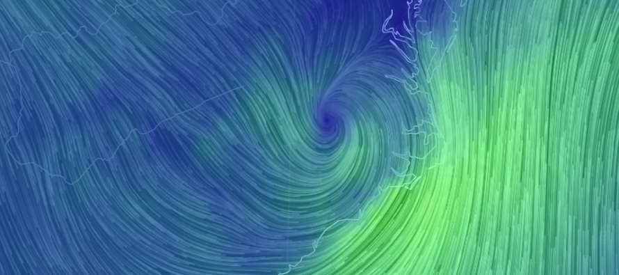
After delivering catastrophic damage to the Florida panhandle and many other instances of secondary damage to parts of the SE US, Michael’s remnants have weakened to tropical storm criteria. The energy should track from its current ~interior South Carolina location over Delmarva and through the 40N/70W benchmark. During this time the system should transition into a sub-tropical cyclone before ultimately moving out into the N Atlantic Ocean and absorbing into the jet stream.
For New Jersey this means a rainy and windy tonight through tomorrow with embedded thunderstorms possible. There’s some funky dynamics aloft with the remnant cyclonic flow beneath the approaching upper jet. Rainfall amounts should vary with NWNJ seeing the least and SENJ seeing the most. My best guess is anything from a half-inch in NWNJ up to 4 inches in extreme SENJ. Winds could gust to 50mph for the SENJ coastal area. Less for points inland and N of SENJ. The highest winds should occur on the back side of the storm tomorrow morning through afternoon/evening (out of the N/NW). This flow should then usher in a colder and drier air mass for the rest of the weekend—much colder when compared to recent conditions.

In English: Rain and wind are expected this evening through tomorrow morning. Embedded thunderstorms are possible. As little as a half-inch for NWNJ and as much as 4+ inches for extreme SENJ. Winds should be moderate-to-high with gusts to 40mph+ possible. The rain should cut off by late tomorrow morning but colder N/NW winds should persist through tomorrow afternoon/evening. That should set the stage for true fall weekend conditions possibly sustaining for a while. I’ll have the full weekend outlook out later this evening. Be safe! JC
Jonathan Carr (JC) is the founder and sole operator of Weather NJ, New Jersey’s largest independent weather reporting agency. Since 2010, Jonathan has provided weather safety discussion and forecasting services for New Jersey and surrounding areas through the web and social media. Originally branded as Severe NJ Weather (before 2014), Weather NJ is proud to bring you accurate and responsible forecast discussion ahead of high-stakes weather scenarios that impact this great garden state of ours. All Weather. All New Jersey.™ Be safe! JC


LOCAL FORECAST | INTERACTIVE RADAR | LATEST NJ WEATHER ALERTS | WEDDING FORECAST| PRIVACY POLICY
© Copyright 2026 Weather NJ LLC. All Rights Reserved.
Some information that can be found on our website is provided by a private weather station and is not an officially recognized station for weather reporting. Though we always strive to achieve accurate reporting for our own use, it is important that you do NOT depend on the data provided here for any purpose.
