

Oct 14: Coastal Storm Developing
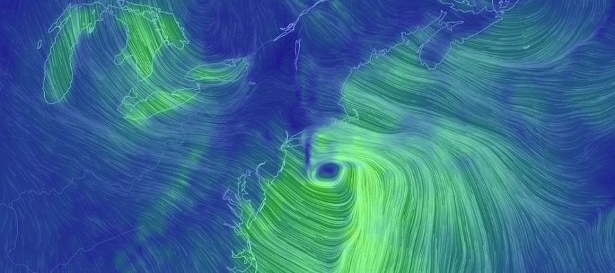
Discussion: Another October coastal storm is about to develop and hit coastal New England. This is the long-range storm signal that showed up a little over a week ago and with good reason. The upper-levels have remained impressively modeled well into the mid-range forecasting period. I’m seeing some very deep 500mb geopotential height anomalies in the expected upper-level low/trough. I’m also seeing some amped Positive Vorticity Advection (PVA) in the SE quadrant of the upper-level low that should spawn a surface low just off SE NJ/Delmarva Wednesday evening. This should be the location of best surface area pressure drops under the PVA-influenced divergence aloft. From there it should explode into a nor’easter and track towards the Cape Cod/Gulf of Maine area. But for NJ things do not happen fast enough for more destructive impacts. We will instead see the developing stages of this system on Wednesday in the form of heavy rainfall and gusty S/SE winds. But on Thursday maybe into some of Friday, when the system is flexing for New England, NJ should see the system’s back-end wind field. Winds should subside by Friday PM hours as we calm down for the weekend. As far as New Jersey impacts from this developing nor’easter here they are broken down by category:
Rainfall: Model guidance is in fair agreement of moderate-to-heavy rainfall between Wednesday morning and early Thursday AM. The GFS is least aggressive with a range of .5 to 1.5 inches of rainfall. The Euro is more aggressive with a range of .75 to 3 inches. The shorter-range NAM is near the middle with a general .75 to 2 inches. Let’s not get caught up in exact amounts. The full range of everything showing is still a decent amount of rainfall. For that reason flash-flooding is a possibility at times. Again the rain should fall between mid-to-late Wednesday morning and early Thursday AM hours.
Wind: NJ should see two phases of wind impacts. First are the S/SE winds that will start ahead of the rainfall and peak with the heaviest rainfall. I’m not expecting anything crazy in this first wind phase. They should be felt the strongest along the S/SE NJ coast between Wednesday morning and evening. I’m thinking sustained 10-20mph with gusts to 30-35mph. The strongest winds (wind phase 2) should occur Thursday into Friday once the system moves on to bop New England. The rain will be shut off Thursday AM so NJ will see a dry and gusty day out of the NW. I wouldn’t be surprised to see NW or W/NW wind gusts of 40mph+ Thursday into Friday AM. Since the system will stick around coastal New England through Friday so will our dry NW gusty winds. By Friday evening NJ should start to see winds subside. The weekend then looks much calmer wind-wise.
Flooding: Winds should push a small amount of ocean against S/SE NJ as the system develops and tracks in from the SW. Once the low pops off SENJ/Delmarva Wednesday evening we could see a small window of onshore flow but not significant to warrant greater coastal flooding concern. Once winds switch to the NW behind the system (Wednesday night-forward) the winds will actually favor lower tides than higher tides. The greatest form of flooding risk should be flash-flooding from periods of heavy rainfall struggling to drain efficiently. The risk for flash flooding should adhere to the rainfall schedule between Wednesday morning and early Thursday AM.
In English: Another nor’easter is forming but not in enough time to hit NJ head-on. It will instead hit New England head-on with the worst of it. NJ however should see a period of heavy rainfall and moderate wind between Wednesday morning and late-Wednesday night as the system develops. NJ should then see cold and dry skies Thursday into Friday with even gustier winds out of the NW. Secure your Halloween decorations and small people. Have a great rest of your Columbus Day and please be safe! JC
Download the new free Weather NJ mobile app on Apple and/or Android. It’s the easiest way to never miss Weather NJ content. Our premium services go even further above and beyond at the hyper-local level. Looking for industrial-caliber long-range forecasting data that I personally recommend? Check out WeatherTrends360!
Jonathan Carr (JC) is the founder and sole operator of Weather NJ, New Jersey’s largest independent weather reporting agency. Since 2010, Jonathan has provided weather safety discussion and forecasting services for New Jersey and surrounding areas through the web and social media. Originally branded as Severe NJ Weather (before 2014), Weather NJ is proud to bring you accurate and responsible forecast discussion ahead of high-stakes weather scenarios that impact this great garden state of ours. All Weather. All New Jersey.™ Be safe! JC


LOCAL FORECAST | INTERACTIVE RADAR | LATEST NJ WEATHER ALERTS | WEDDING FORECAST| PRIVACY POLICY
© Copyright 2026 Weather NJ LLC. All Rights Reserved.
Some information that can be found on our website is provided by a private weather station and is not an officially recognized station for weather reporting. Though we always strive to achieve accurate reporting for our own use, it is important that you do NOT depend on the data provided here for any purpose.
