

Oct 15: Coastal Storm Approaching
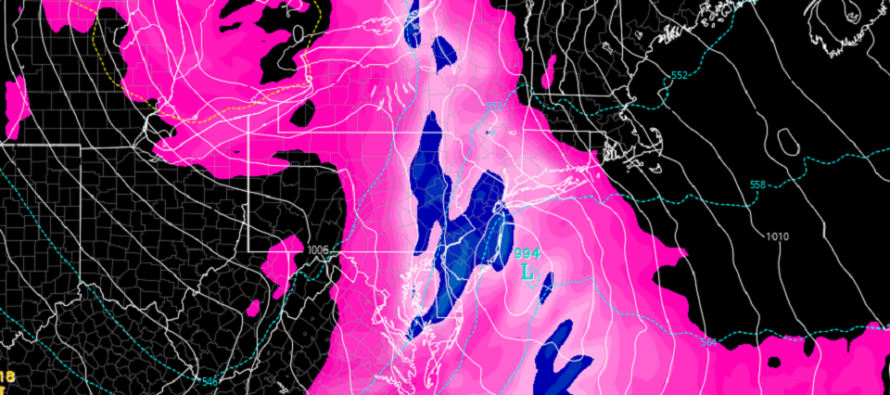
Discussion: Our coastal storm players are on the field. You can see the energy across the SE US (just N of the Gulf Coast) which will turn and track up the coast and interact with the strong Upper-Level Low (ULL). As I’ve said leading into this storm system, coastal New England should take the worst of it Thursday-Friday. New Jersey will be subject to the following conditions as the storm develops over us Wednesday into Thursday:
Rainfall: Model guidance remains fairly consistent and unanimous with a widespread 1 to 2 inches of rainfall between late Wednesday morning and early Thursday AM hours. I imagine the peak rainfall should occur during NJ’s Wednesday PM rush hour. This amount of liquid dropped in that short amount of time could lead to flash flooding in areas of poor drainage. This should help the drought but cause widespread weather issues for travel especially by air.
Wind: NJ should first see breezy-to-gusty winds out of the S/SE starting tonight and lasting through tomorrow’s rainfall. The S/SE NJ coast should feel the brunt of this with lesser wind gusts away from the ocean. Once the coastal low forms off the NJ coast (Wednesday evening) then winds will switch to the NW and intensify as the system intensifies for coastal New England. The windiest period of this entire event should therefore be from Wednesday night through all of Thursday. It might be Friday before winds subside due to the system stalling for coastal New England. For this second wind period expect wind gusts in-excess of 40mph out of the NW.
Flooding: NJ should see some minor ocean water pushed against the S/SE NJ coast with the S/SE flow before and during the rain (most of Wednesday). Once the winds switch to the NW and become stronger there will be no coastal flooding threat as this will push the ocean away from the NJ coast. Therefore flash flooding is the highest flooding concern not coastal flooding. That doesn’t meant that barrier islands won’t have water in the streets from heavy rainfall however. It just likely won’t be salt water back-filling in from the drains.
In English: No major changes to yesterday’s analysis of the developing coastal storm system. Rain and wind (out of S/SE) Wednesday followed by clearing and even windier conditions (out of NW) from Wednesday night through Thursday possibly into Friday. You might see the S/SW winds start to pick up tonight. Again, secure small human beings and any loose Halloween decorations! Thursday’s wind will be statewide not just confined to the coast. Have a great night and please be safe! JC
Download the new free Weather NJ mobile app on Apple and/or Android. It’s the easiest way to never miss Weather NJ content. Our premium services go even further above and beyond at the hyper-local level. Looking for industrial-caliber long-range forecasting data that I personally recommend? Check out WeatherTrends360!
Jonathan Carr (JC) is the founder and sole operator of Weather NJ, New Jersey’s largest independent weather reporting agency. Since 2010, Jonathan has provided weather safety discussion and forecasting services for New Jersey and surrounding areas through the web and social media. Originally branded as Severe NJ Weather (before 2014), Weather NJ is proud to bring you accurate and responsible forecast discussion ahead of high-stakes weather scenarios that impact this great garden state of ours. All Weather. All New Jersey.™ Be safe! JC


LOCAL FORECAST | INTERACTIVE RADAR | LATEST NJ WEATHER ALERTS | WEDDING FORECAST| PRIVACY POLICY
© Copyright 2026 Weather NJ LLC. All Rights Reserved.
Some information that can be found on our website is provided by a private weather station and is not an officially recognized station for weather reporting. Though we always strive to achieve accurate reporting for our own use, it is important that you do NOT depend on the data provided here for any purpose.
