

Oct 18: Coastal Storm Developing
Discussion: The data has trended wetter and windier for Sunday’s coastal system brush. I’ll say right off the bat that areas along and NW of the Turnpike will likely see minimal impacts if any. Areas along the SENJ/ECNJ coast however are subject to heavier rain and stronger winds.
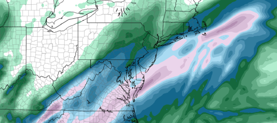
We have building heights along the east coast and a developing central US trough. These steering influences should take our system (now Tropical Storm Nestor in the Gulf of Mexico) over the Florida panhandle, across the SE US and into the Atlantic Ocean somewhere between Delmarva and OBX. The difference between Delmarva and OBX represents the spread of model guidance. The global models are favoring OBX while shorter-range models like the NAM are favoring Delmarva.
If it tracks over Delmarva then most of NJ is subject to at least some rainfall. Areas SE of the Turnpike would have the better chance with immediate SENJ coastal areas the best chance. The Delmarva track would mean up to 2 inches of rainfall along the SENJ coast with amounts tapering down to a half-inch near the Turnpike. Lesser amounts of rain would fall NW of the Turnpike with a cut-off somewhere in EPA/NWNJ. This would be the windier scenario with gusts of 30-40mph along the immediate SENJ coast. Wind strength would be weaker away from the ocean due to land friction.
If it tracks over OBX than statewide NJ impacts would be reduced. Immediate coastal areas would only be subject to a half-inch of rainfall with lesser amounts sharply cutting off along or just NW of the Turnpike. Wind values would be less as the system’s core wind field would likely be just offshore of SENJ.
In either case (Delmarva vs OBX track) minor coastal flooding is possible. I’m not really seeing moderate or worse due to the short duration of onshore flow. Like this last nor’easter there’s probably a better chance of flash flooding in SENJ than coastal flooding due to rainfall (in the Delmarva track scenario).
Let’s give it a day of more model data and live observations. Tomorrow we should be able to further tweak the track (between Delmarva and OBX) and have a better idea of impact (light rain and wind vs heavier rain and moderate wind). System impacts would begin around mid-to-late Sunday morning and wrap up before midnight Sunday night. Peak conditions for SENJ would occur Sunday afternoon.
In English: Another coastal storm is developing that should brush at least SENJ (along and SE of the Turnpike) this Sunday. We’re looking at least at light rain and wind, possibly heavier rain and moderate wind, depending on the track of the system. Tomorrow should solidify the expected track to allow expected specific rainfall amounts and wind values. Tonight looks cold. Saturday looks good. Sunday not so much especially for SENJ. Have a great rest of your Friday and please be safe! JC
Download the new free Weather NJ mobile app on Apple and/or Android. It’s the easiest way to never miss Weather NJ content. Our premium services go even further above and beyond at the hyper-local level. Looking for industrial-caliber long-range forecasting data that I personally recommend? Check out WeatherTrends360!
Jonathan Carr (JC) is the founder and sole operator of Weather NJ, New Jersey’s largest independent weather reporting agency. Since 2010, Jonathan has provided weather safety discussion and forecasting services for New Jersey and surrounding areas through the web and social media. Originally branded as Severe NJ Weather (before 2014), Weather NJ is proud to bring you accurate and responsible forecast discussion ahead of high-stakes weather scenarios that impact this great garden state of ours. All Weather. All New Jersey.™ Be safe! JC


LOCAL FORECAST | INTERACTIVE RADAR | LATEST NJ WEATHER ALERTS | WEDDING FORECAST| PRIVACY POLICY
© Copyright 2026 Weather NJ LLC. All Rights Reserved.
Some information that can be found on our website is provided by a private weather station and is not an officially recognized station for weather reporting. Though we always strive to achieve accurate reporting for our own use, it is important that you do NOT depend on the data provided here for any purpose.
