

Oct 19: Coastal Storm Approaching
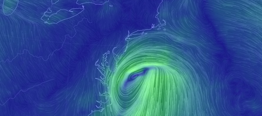
Discussion: Remnants of Nestor are approaching in the form of an extra-tropical cyclone. Not a nor’easter by my criteria but certainly a coastal storm. There are no tricks in the upper-levels. This system is heading into an establishing ridge and will likely fizzle out to nothing by the time it passes just SE of the 40N 70W Benchmark. It’s a weak cyclone overall with an estimated pressure of ~1000mb when nearest NJ. It’s track however should allow us to experience a temporary rain/wind storm. The approaching cold front for early this coming week will actually absorb some of the upper-level energy left behind the fizzle.
So what does this mean for NJ on Sunday? Well let’s cover areas along and NW of the I-95/NJ Turnpike corridor. For these areas I would expect nuisance rain and wind. Whether you see one-tenth of an inch or maybe a few tenths of an inch of rainfall is still somewhat uncertain but you will likely see less than a half-inch. The further NW you are from the big city corridor the less rain chance you have. Winds should be mostly confined to just the breezy category with maybe occasional/manageable gusts. For areas SE of the I-95/NJTP corridor let’s break the impacts down:
Rain: I’m thinking the most amount of rainfall possible, right up against the I-95/NJTP corridor, is a half-inch. I’m thinking the most amount of rainfall the extreme SENJ coast could see is up to 2 inches. So at most a half-inch to 2 inches from the I-95/NJTP corridor to the SENJ coast (they run almost parallel). I think the lower end of that range is a quarter-inch to three-quarters of an inch (I-95/NJTP to SENJ coast). That’s about the best range I can set right now for rainfall expectations tomorrow (Sunday) between 9AM and 9PM. Peak rainfall conditions would likely occur from early-afternoon to early-evening.
Wind: For everyone away from the ocean winds should be manageably breezy-to-gusty. For those along the immediate ECNJ/SENJ coasts winds crank some. I would expect sustained winds of 15-25mph with gusts of 35-45mph right along immediate coastal areas. The strongest winds should occur from Sunday afternoon through Monday morning hours—extending beyond the anticipated rain ending Sunday night. Winds should subside by Monday PM hours and then quickly switch out of the S/SW ahead of the expected Tuesday night cold front passage.
Flooding: Not really seeing any coastal flooding concerns beyond immediate barrier islands flirting with minor criteria. It’s not a “bad for flooding” moon phase and the onshore flow wind component is of short-duration. Maybe some slightly elevated tides Sunday and Monday but that’s about it. I don’t think flash flooding will be a concern either. SENJ would have the best chance to see it but not likely in a short-enough period to warrant a flash flood. Otherwise the ocean should be very rough and dangerous on Sunday.
Timing: Again this all starts by mid-to-late Sunday morning (9am to play it safe). Conditions should then peak between afternoon and early-evening with rain ending by Sunday night. Winds could extend into Monday morning while gradually subsiding.
In English: A coastal storm is approaching and should graze SENJ (SE of the I-95/NJTP corridor). SENJ is favored for the most rainfall and wind. NWNJ is favored to see the least amount of action. The difference between nuisance rain/breeze and a rainstorm should occur somewhere near or just SE of the I-95/NJTP corridor. It starts around 9am Sunday morning and ends Sunday night/early Monday AM. Have a great rest of your Saturday and please be safe! JC
Download the new free Weather NJ mobile app on Apple and/or Android. It’s the easiest way to never miss Weather NJ content. Our premium services go even further above and beyond at the hyper-local level. Looking for industrial-caliber long-range forecasting data that I personally recommend? Check out WeatherTrends360!
Jonathan Carr (JC) is the founder and sole operator of Weather NJ, New Jersey’s largest independent weather reporting agency. Since 2010, Jonathan has provided weather safety discussion and forecasting services for New Jersey and surrounding areas through the web and social media. Originally branded as Severe NJ Weather (before 2014), Weather NJ is proud to bring you accurate and responsible forecast discussion ahead of high-stakes weather scenarios that impact this great garden state of ours. All Weather. All New Jersey.™ Be safe! JC


LOCAL FORECAST | INTERACTIVE RADAR | LATEST NJ WEATHER ALERTS | WEDDING FORECAST| PRIVACY POLICY
© Copyright 2026 Weather NJ LLC. All Rights Reserved.
Some information that can be found on our website is provided by a private weather station and is not an officially recognized station for weather reporting. Though we always strive to achieve accurate reporting for our own use, it is important that you do NOT depend on the data provided here for any purpose.
