

Oct 20: Coastal Storm Begins
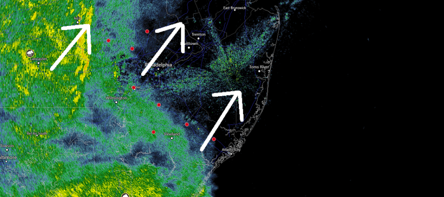
Discussion: Good morning! In the upper-levels we have some remnant energy barely recognizable as a short-wave on 500mb analysis. Just a small hiccup in the establishing E US/W Atlantic Ridge. At the surface we have an extra-tropical cyclone (now establishing frontal boundaries) tracking in from the SW towards Delmarva. This system was once a tropical system in the Gulf of Mexico but is now a progressive low—a coastal low NOT a nor’easter. There is no stall or retrograde to classify this as a nor’easter. The ridge is expected to flex when the low nears the S tip of Delmarva which should turn the system’s track from N/NE to E/NE. This should pull the precipitation shield with it and ultimately lower rainfall amounts for most areas along and N of I-78. Rainfall amounts for all SNJ counties however should be on the higher end of expectations. Let’s break everything down by impact category:
Rain: It is completely plausible to see at least a half-inch of rain fall along and maybe even just NW of I-95. There should be a sharp cut-off to the NW of this half-inch mark but live observations and short-range model guidance are looking a little wetter and slightly more NW today. For everyone SE of I-95 or S of I-78 rainfall amounts could easily exceed 1 inch and in some places two inches.
Wind: Wind is not a big deal with this system away from the ocean. Immediate coastal areas however (from Cape May to Sandy Hook) should expect sustained winds of 15-25mph with occasional gusts in the 35-45mph range. Example: Harvey Cedars reports a wind gust of 37mph. Toms River says what wind?
Flooding: Coastal flooding remains a minor risk at most. The onshore flow E wind component is of short duration and therefore inhibiting of wind-related storm surge. Astronomical tides are also not running high. A lot of rainfall might have no place to drain but that’s more of a flash flooding issue than coastal flooding issue. With that said there’s a small risk of flash flooding for SENJ areas today that see the heaviest rain bands. The highest expected tide level is actually around noon on Monday well-after the rain shuts off. Again likely minor levels at most.
In English: Rain is just now approaching SWNJ. It should spread throughout the rest of NJ over the next few hours. NNJ/NENJ the last to see rain start by early afternoon. Rainfall should peak during afternoon hours and taper off from W to E before midnight. SNJ is favored for more rainfall than NNJ. NWNJ the best chance to stay dry. Winds should be no big deal away from the ocean but gusty along the immediate coast (this afternoon through tomorrow morning). Coastal flooding remains a minor risk at most. Monday’s high tide should be the highest the tide gets…not today. Everyone stay dry and be safe! JC
Download the new free Weather NJ mobile app on Apple and/or Android. It’s the easiest way to never miss Weather NJ content. Our premium services go even further above and beyond at the hyper-local level. Looking for industrial-caliber long-range forecasting data that I personally recommend? Check out WeatherTrends360!
Jonathan Carr (JC) is the founder and sole operator of Weather NJ, New Jersey’s largest independent weather reporting agency. Since 2010, Jonathan has provided weather safety discussion and forecasting services for New Jersey and surrounding areas through the web and social media. Originally branded as Severe NJ Weather (before 2014), Weather NJ is proud to bring you accurate and responsible forecast discussion ahead of high-stakes weather scenarios that impact this great garden state of ours. All Weather. All New Jersey.™ Be safe! JC


LOCAL FORECAST | INTERACTIVE RADAR | LATEST NJ WEATHER ALERTS | WEDDING FORECAST| PRIVACY POLICY
© Copyright 2026 Weather NJ LLC. All Rights Reserved.
Some information that can be found on our website is provided by a private weather station and is not an officially recognized station for weather reporting. Though we always strive to achieve accurate reporting for our own use, it is important that you do NOT depend on the data provided here for any purpose.
