

Oct 23: Coastal Storm Detected
Discussion: The Oct 27-31 synoptic storm signal that I’ve been tracking since ~Oct 10 will likely come into fruition this weekend. The source? Hurricane Willa in the Pacific Ocean.
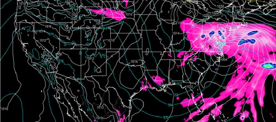
Willa is currently located S of the Baja Peninsula and just W of the coast of Mexico. It should soon make landfall and cross Mexico towards the northern Gulf of Mexico coast (N Gulf US). By this time Willa will have likely transitioned from a tropical warm core system to a traditional mid-latitude cyclone of extra-tropical nature (development of frontal boundaries surrounding colder central cyclonic flow). Willa’s remnant energy should then crawl the northern Gulf coast on Thursday and the SE US coast early Friday. Further cyclogenesis is expected as the system moves from OBX towards EPA/WNJ Friday evening through Sunday morning.
Both the GFS and Euro global operational models have a sub-1000mb intensity by the time it impacts New Jersey. Not a superstorm by any means. Total storm precipitation is likely in the 1-3 inch range (locally 4 inches). Winds should be more intense along the E coast of NJ and less intense the further inland you get. I could see gusts to 40mph along the immediate coast and gusts of 20-30mph inland. Sustained wind values would be less.
Aside from the run-of-mill October rain and wind coastal storm, a coastal flooding risk exists. We’re looking at a ~36-hour period of onshore flow which should feature at least 3-4 high tides of concern. At this point I would guess minor-to-moderate stage coastal flooding is possible. I’ll be paying close attention to this as we get closer to the weekend.
Models are still in disagreement about timing of precipitation. The Euro starts rain as early as 7PM on Friday and ends the rain as early as Saturday evening. The GFS has an early-Saturday AM start with a Sunday late-morning/early-afternoon finish. Basically the Euro is earlier in and earlier out. All we can do at this point for safety awareness is consider the overall Friday evening to Sunday afternoon period as the storm potential. This has been narrowed from the original Oct 27-31 period I’ve been barking about in prior weekly outlooks. I hope to narrow this timing even moreso by tomorrow.
In English: Periods of heavy rain, moderate wind and coastal flooding are possible between this Friday evening and Sunday afternoon with Saturday seeing the meat and potatoes of the storm system. That expected period should shrink on each side by a few hours depending on how live observations play out compared to the model data. It’s not a superstorm. It’s not a tropical impact. It’s a typical October coastal storm. It’s an outdoor plan wrecker. Not a state breaker. Stay warm and dry and you’ll be fine. Let’s check back in tomorrow afternoon to see if we can’t narrow the expected timing down further. Thanks and be safe! JC
Jonathan Carr (JC) is the founder and sole operator of Weather NJ, New Jersey’s largest independent weather reporting agency. Since 2010, Jonathan has provided weather safety discussion and forecasting services for New Jersey and surrounding areas through the web and social media. Originally branded as Severe NJ Weather (before 2014), Weather NJ is proud to bring you accurate and responsible forecast discussion ahead of high-stakes weather scenarios that impact this great garden state of ours. All Weather. All New Jersey.™ Be safe! JC


LOCAL FORECAST | INTERACTIVE RADAR | LATEST NJ WEATHER ALERTS | WEDDING FORECAST| PRIVACY POLICY
© Copyright 2026 Weather NJ LLC. All Rights Reserved.
Some information that can be found on our website is provided by a private weather station and is not an officially recognized station for weather reporting. Though we always strive to achieve accurate reporting for our own use, it is important that you do NOT depend on the data provided here for any purpose.
