

Oct 27: First Snow for NJ Elevations?
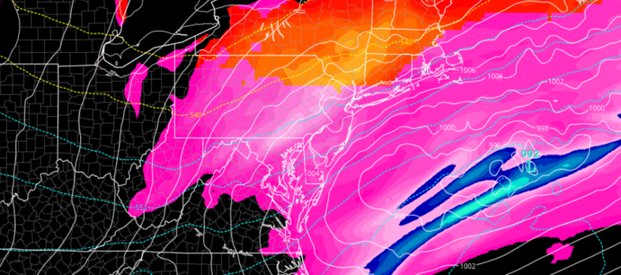
Discussion: Tropical Storm ZETA should intensify into a hurricane by tomorrow (Wednesday) morning before making landfall later tomorrow evening in the coastal Louisiana area. After that, ZETA will quickly lose it’s tropical characteristics and transition into a mid-latitude cyclone while tracking over the SE US. This energy should then eject into the Atlantic Ocean over the ~Delmarva latitude of the US east coast on Friday.
Once over the Atlantic Ocean, this synoptic system is expected to stall a bit, and even possibly retrograde, as another area of energy moves in from the W. This other energy is currently bringing wintry precipitation to New Mexico and will also track towards ~Delmarva, meeting up just behind ZETA’s remnants to pull them back W a bit. Hence the retrograde of the coastal low that was once ZETA. This should keep precipitation in the NJ area starting as early as Thursday AM (initial warm front/overrunning) and tapering off by Friday evening. Peak precipitation would likely occur between Thursday night and Friday morning.
Everything looks way too warm for anything but rain Thursday AM through Friday AM. However, once the low is offshore, NJ winds will become northerly (backside/westside of cyclonic flow). At that time, an area of high pressure will be centralized over the Great Lakes, providing additional N flow over NJ. This will allow a cold air injection from the N capable of converting rain to snow for the higher elevations of New Jersey (N of I-80 and NW of I-287). We’ll have colder mid-levels and upper-levels with the trough arrival. This period of potential wintry changeover would be from Friday morning until precipitation tapers off later Friday afternoon (early Friday evening at the absolute latest).
I doubt accumulations would be anything more than conversational aside from maybe the top summits of Sussex County (High Point, NJ) area. That region always behaves like a different planet when temps and precipitation types are concerned…more like the Poconos or even Catskills. Maybe a few inches stack up that way but meh. It’s a very small geographic area compared to the rest of NJ which will likely only see rain from this system. The rain however should transition from mild to at least cold as ZETA’s remnants transition to the trailing colder low.
As far as wind goes, we’ll have a nearby sub-1000mb cyclone at times. Therefore, it could become breezy, possibly gusty at times (30-40mph), but nothing overly damaging wind-wise. Coastal flooding is possible for the periods of direct onshore flow but likely only held to the minor stage.
Once everything clears out by sundown on Friday, we’re looking at a cold and dry Friday overnight through all of Saturday as the lakes high pressure moves overhead. By Sunday that high will be offshore with return flow bringing back milder temps and possibly some more rain by Sunday night. I’ll cover that more in the weekend outlook (to be released Thursday evening).
In English: Mild-feeling rain should arrive in NJ by Thursday morning. Rainfall, possibly heavy at times, should persist through all of Thursday and into Friday with temperatures gradually dropping throughout the period. Most of New Jersey (90% or more) will likely only see rain from this event. NWNJ elevations however could become cold enough by Friday to see a transition from rain to snow. Accumulations N of I-80/NW of I-287 would likely be little-to-none with maybe a bit more stacking up on natural surfaces for the highest elevations of Sussex County (High Point, NJ area). It’s not a big deal but it will likely be the first snow for the elevations. I’ll provide an updated forecast for this system tomorrow and then a real-time observation report in the routine weekend outlook on Thursday. Everyone have a great rest of your Tuesday evening and please be safe! JC
Download the free Weather NJ mobile app on Apple and/or Android. It’s the easiest way to never miss Weather NJ content. Our premium services go even further above and beyond at the hyper-local level.
Jonathan Carr (JC) is the founder and sole operator of Weather NJ, New Jersey’s largest independent weather reporting agency. Since 2010, Jonathan has provided weather safety discussion and forecasting services for New Jersey and surrounding areas through the web and social media. Originally branded as Severe NJ Weather (before 2014), Weather NJ is proud to bring you accurate and responsible forecast discussion ahead of high-stakes weather scenarios that impact this great garden state of ours. All Weather. All New Jersey.™ Be safe! JC


LOCAL FORECAST | INTERACTIVE RADAR | LATEST NJ WEATHER ALERTS | WEDDING FORECAST| PRIVACY POLICY
© Copyright 2025 Weather NJ LLC. All Rights Reserved.
Some information that can be found on our website is provided by a private weather station and is not an officially recognized station for weather reporting. Though we always strive to achieve accurate reporting for our own use, it is important that you do NOT depend on the data provided here for any purpose.
