

Oct 28: Rainstorm Approaching
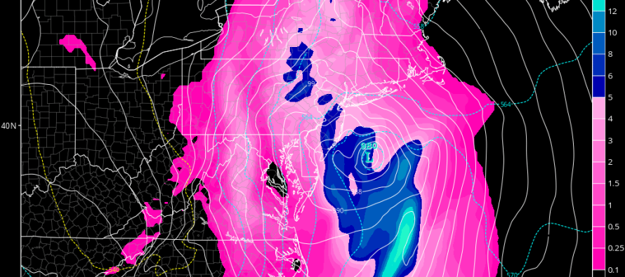
Discussion: Typhoon Lan has moved through the west Pacific Ocean into the Bering Sea. This has produced strong ridging in the Gulf of Alaska/W US area (+PNA) which has symbiotically produced a trough for the E US. The trough is expected to contain enhanced lifting along the leading cold front which should merge up with a subtropical disturbance tracking northward out of the Bahamas. The trough axis is expected to tilt strongly negative after the coupling of the jet streams (the phase). This should produce a high impact rain and wind event for New England however the phase now looks to be too late for the most damaging New Jersey outcome. Therefore I think New Jersey looking at more of a strong frontal rain event rather than a synoptic bomb-out low having a more concerning impact (like what will happen for New England). The two upper-level systems should phase near-over or just NE of New Jersey. Given the progressive SW to NE movement of the energy, that is too late for the phase to produce the worst case scenario for NJ impact. So again, don’t get me wrong, it is going to pour with gusty winds tomorrow from late-morning through early Monday AM…but we should all be okay. One wildcard scenario is a dry slot in precipitation, mostly for SWNJ, if the phase places said area in the most immediate warm sector. This is why I think NENJ should take the worst of this system re: NJ impacts.
Tonight is the second and final night of Operation Halloween!
In English: Rainfall could start in the early hours of Sunday AM but should really get going by late-morning. From about noon on Sunday through Sunday evening/night, periods of moderate-to-heavy rainfall are expected. NENJ should see the most rainfall (2-4 inches). SWNJ should see the least (1-3 inches). Everyone between NENJ and SWNJ should range between that. Winds should be gusty with sustained values in the 20-30mph range and gusts possibly exceeding 40mph and even reaching 50mph. I would expect the greatest winds to occur for immediate coastal regions and NNJ. Areas away from the ocean should likely see lesser winds but likely still noticeable gusts. Embedded thunderstorms are possible which could produce localized instances of higher wind gusts but we’ll have to play that by radar. Given the fast-moving nature of this system, only minor risk of coastal flooding exists. You’ll know when the center of the storm energy passes over you because winds will shift from SE and mild to NW and cold. Monday we should dry out with with W/NW flow. Let’s allow through sunrise for the last remnant rainfall to taper off. I’ll have the full Monday-Friday Outlook posted tomorrow night. Have a great rest of your weekend and please be safe! JC
Model image from TropicalTidbits.com
Jonathan Carr (JC) is the founder and sole operator of Weather NJ, New Jersey’s largest independent weather reporting agency. Since 2010, Jonathan has provided weather safety discussion and forecasting services for New Jersey and surrounding areas through the web and social media. Originally branded as Severe NJ Weather (before 2014), Weather NJ is proud to bring you accurate and responsible forecast discussion ahead of high-stakes weather scenarios that impact this great garden state of ours. All Weather. All New Jersey.™ Be safe! JC


LOCAL FORECAST | INTERACTIVE RADAR | LATEST NJ WEATHER ALERTS | WEDDING FORECAST| PRIVACY POLICY
© Copyright 2026 Weather NJ LLC. All Rights Reserved.
Some information that can be found on our website is provided by a private weather station and is not an officially recognized station for weather reporting. Though we always strive to achieve accurate reporting for our own use, it is important that you do NOT depend on the data provided here for any purpose.
