

Oct 7: Matthew Update + NJ Weekend Rainfall
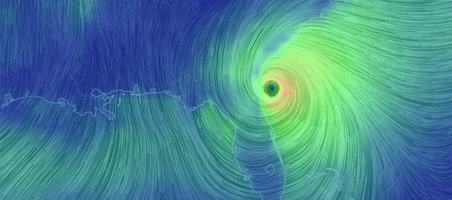
Matthew is still a strong category 2 hurricane per the latest 8PM NHC update. I expect him to gradually weaken as he further interacts with the curvature of the SE US coast. Right now, he is throwing a lot of storm surge and rainfall into coastal Georgia and South Carolina. Luckily, the eye of Matthew has remained just, and I mean JUST, off the coast of Florida between last night and present. The only area that came close to being inside the actual eye was the Space Coast of Florida (Cape Canaveral area) which saw a 107mph wind gust. We now have to see if he will stay just off the SC/GA coast or possibly make landfall in that region. Either way, coastal Georgia and South Carolina are in for a rough 24 hours, with heavy rainfall, dangerous storm surge and tropical storm to hurricane-force winds.
After Matthew moves away from the US East Coast on Sunday, he might very well curve back to the S towards the Bahamas again. He will not merge with Nicole but they could dance around each other a bit in what’s called a Fujiwhara effect. Google it, it’s cool. Should Matthew make it to the Bahamas again, he would likely be in a very weakened state mostly due to shear and exhausted dynamics. Let’s cross that bridge in a few days but that’s what I see right now.
Matthew might have secondary impacts to our region this weekend by contributing to rainfall along an approaching cold front. He could also team up with the onshore flow associated with high pressure to our N and create a nuisance onshore windy environment for the Jersey Shore. Such impacts would be felt less away from the ocean. SENJ would likely see the windiest conditions. Heck that might even lead to some minor coastal flooding in places that usually see water in the streets. But what it will NOT be is Matthew coming on shore. I just don’t want anyone to think that’s what’s happening when conditions naturally deteriorate along the cold front Saturday into Sunday. 15-25mph sustained winds out of the E/NE or NJ with gusts to 30mph? Sure that’s possible. But not hurricane-force winds by any means.


In English: Matthew is currently impacting coastal Georgia and South Carolina. He should gradually weaken from hereon out and then eject off the coast just S of OBX by Sunday. He could then loop back to the Bahamas later next week. As far as Jersey is concerned, expect some rainfall Saturday into Sunday with the approaching cold front but also expect some of Matthew’s northernmost energy to throw some additional rain and onshore winds into the equation. Nothing crazy but a nuisance for sure, especially for SENJ. Nicole will not impact New Jersey. She will remain a fish storm but possibly interact with Matthew a bit. Rain could move in as early as Saturday morning and clear as late as noon on Sunday, if not earlier. Have a great weekend and please be safe! JC
Jonathan Carr (JC) is the founder and sole operator of Weather NJ, New Jersey’s largest independent weather reporting agency. Since 2010, Jonathan has provided weather safety discussion and forecasting services for New Jersey and surrounding areas through the web and social media. Originally branded as Severe NJ Weather (before 2014), Weather NJ is proud to bring you accurate and responsible forecast discussion ahead of high-stakes weather scenarios that impact this great garden state of ours. All Weather. All New Jersey.™ Be safe! JC


LOCAL FORECAST | INTERACTIVE RADAR | LATEST NJ WEATHER ALERTS | WEDDING FORECAST| PRIVACY POLICY
© Copyright 2026 Weather NJ LLC. All Rights Reserved.
Some information that can be found on our website is provided by a private weather station and is not an officially recognized station for weather reporting. Though we always strive to achieve accurate reporting for our own use, it is important that you do NOT depend on the data provided here for any purpose.
