

Oct 8: Coastal Storm Approaching
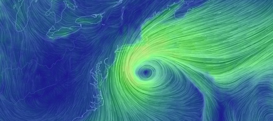
Discussion: After reviewing 24 more hours of model guidance and live observations I think we’re locking onto a more defined solution for the coastal storm. The offshore storm system is approaching now and I’d like to break the impacts down as follows:
Rain: Between now and Saturday morning most model guidance is throwing down between .75 and 1.5 inches of rainfall along and SE of the I-95 corridor. Areas to the NW of I-95 see a steep cutoff of precipitation. There’s the wildcard that NENJ could see a heavier rain band or two but it’s far from guaranteed. Given position and proximity of the storm center to NJ this makes sense. Just keep in mind that such rainfall amounts over 3-4 days won’t seem like a lot from a real-time rainfall intensity point of view. I’d prepare for more of a prolonged drenching mist/light rain with only isolated periods of heavier rain at times. I wouldn’t expect 3-4 days of washout downpour. That’s never been advertised and hopefully no one has left with that impression. Rainfall, although beneficial to the developing drought, is the least of my concerns with this system.
Wind: The trend I’ve been noticing are that winds will want to stay more out of the NE maybe even N/NE. This is the direction that they’ve been gusting today. Atlantic City saw a few gusts near-40mph out of the N/NE today. The rest of the NJ coast has been continuously gusting 20-30mph. Areas even just 5-10 miles away from the ocean are asking, “what winds?” This theme should continue throughout the event. Onshore flow tends to rapidly weaken over land due to land friction. It’s really only the barrier islands and immediate coastal areas (bays, creek mouths, etc.) who should see the higher wind gusts. With that said I think the coast could see gusts of 40-50mph especially when the low retrogrades westward towards NJ for a bit on Thursday. Sustained coastal winds should hold in the 20-30mph throughout the event. Areas away from the ocean should expect breezy conditions, possibly gusty at times, with winds out of the N. But definitely less wind impact away from the ocean than near/on the ocean. We’ve seen this kind of wind before many times. All the typical power outage and downed tree caveats should be applied especially for populated coastal areas.
Coastal Flooding: This is my greatest concern of all storm impacts. As I mentioned above the winds will be more out of the NE even N/NE. Normally this is not a bad wind for coastal flooding. It’s perpendicular to most inlets. However we’ll have the storm’s center just S of E Long Island. Therefore the wind direction will be dead E between the storm center and Long Island. That’s going to push a lot of water westward towards NJ before the N/NE winds can push it down. There’s no place for the water to go other than into NJ first before banking southward. For this reason I think moderate (small chance of major) coastal flooding is the better assessment than just minor (small chance of moderate). Thursday night’s peak expected coastal flooding levels won’t be that far from Sunday’s full moon. Also tidal observations have been verifying slightly higher than tidal guidance over the last 24-48 hours. For coastal residents I think you need to prepare for more than “just a little water in the streets” just in case. Prepare for that but hope for only minor levels of coastal flooding.
Timing: The immediate ECNJ/SENJ coast is already seeing increased winds. Coastal storm intensity should gradually build through tomorrow (Wednesday) and peak on Thursday. By Friday morning we should be over the hill with conditions improving through Friday night into Saturday morning. I do think this all moves out by mid-to-late morning Saturday.
In English: A nor’easter is approaching. It really won’t be that bad away from the ocean. Immediate coastal areas however should prepare for a prolonged period of rainfall, gusty winds and coastal flooding. It’s just getting here now, should ramp up tomorrow, peak on Thursday and begin moving out on Friday. Tomorrow night I should have a better handle on clear-out timing (somewhere between Friday and Saturday). Have a great night and please be safe! JC
Download the new free Weather NJ mobile app on Apple and/or Android. It’s the easiest way to never miss Weather NJ content. Our premium services go even further above and beyond at the hyper-local level. Looking for industrial-caliber long-range forecasting data that I personally recommend? Check out WeatherTrends360!
Jonathan Carr (JC) is the founder and sole operator of Weather NJ, New Jersey’s largest independent weather reporting agency. Since 2010, Jonathan has provided weather safety discussion and forecasting services for New Jersey and surrounding areas through the web and social media. Originally branded as Severe NJ Weather (before 2014), Weather NJ is proud to bring you accurate and responsible forecast discussion ahead of high-stakes weather scenarios that impact this great garden state of ours. All Weather. All New Jersey.™ Be safe! JC


LOCAL FORECAST | INTERACTIVE RADAR | LATEST NJ WEATHER ALERTS | WEDDING FORECAST| PRIVACY POLICY
© Copyright 2026 Weather NJ LLC. All Rights Reserved.
Some information that can be found on our website is provided by a private weather station and is not an officially recognized station for weather reporting. Though we always strive to achieve accurate reporting for our own use, it is important that you do NOT depend on the data provided here for any purpose.
