

Oct 9: What Michael Means for New Jersey
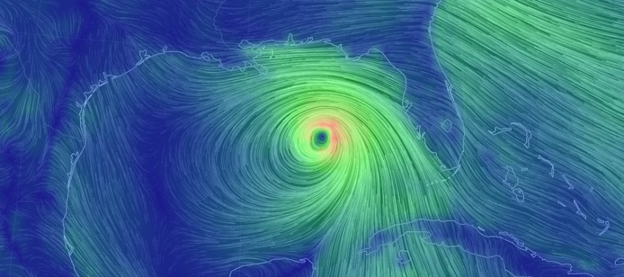
Michael is a category 3 major hurricane heading N towards the coastline between Rosemary Beach and Mexico Beach in Florida. That would put the center of the cone in the Laguna Beach/Panama City area. This is likely where the most destructive winds will occur. The storm surge threat should be catastrophic from the area of exact landfall and all coastal points eastward through Apalachicola and the rest of the Big Bend. Coastal flooding should extend down as far south as Tampa. Landfall looks to occur early tomorrow (Wednesday) afternoon but to play it safe, I’d treat it like late tomorrow morning. For anyone who has family or friends in that area, now is the time to listen to local government authorities regarding evacuations and life safety.
After landfall, Michael will likely weaken to a tropical storm somewhere between passing through Georgia (SE of Atlanta) and South Carolina Wednesday night through Thursday morning. It will then want to pass over North Carolina later on Thursday and ultimately out to sea by Friday. This should present very heavy rainfall for the SE US under that track. It’s not uncommon to see small tornadoes spin up in such conditions. Michael could still be considered a tropical storm when passing over the recent Florence-damaged area of coastal North Carolina.

Michael’s remnants should then transition into a sub-tropical cyclone passing to the SE of New Jersey. For New Jersey this likely means humid rainfall , maybe some embedded thunderstorms, for most of Thursday PM hours through Friday morning. SENJ is still at a slight risk to see elevated but manageable rainfall, winds and coastal flooding in that period. By noon on Friday, Michael’s remnants should be pulling away and it’s lights out for the warm and muggy weather that has dominated the first third of October. This weekend should feature much colder temperatures and dew points via NW flow. Highs in the upper-50s/lower-60s lows in the 30s/40s type stuff.
In English: Michael is going to hit the Florida panhandle pretty hard tomorrow. It will then track across the SE US and miss NJ out to sea. Precipitation however should extend to the NW of Michael and produce a rainy, possibly stormy, Thursday night/Friday morning. It might get pretty crappy (but nothing crazy) along the SENJ coast in that period. This could include heavier rainfall than other parts of NJ, some wind and coastal flooding. Michael’s remnants will be moving fast so not a prolonged event and mostly occurring overnight. Then it’s pumpkin spice magic latte time, possibly “I need a hot chocolate” time, from Friday afternoon through the weekend. Cold and dry! Break out the coats. I’ll cover this in more detail Thursday night for the weekend outlook. Be safe! JC
Jonathan Carr (JC) is the founder and sole operator of Weather NJ, New Jersey’s largest independent weather reporting agency. Since 2010, Jonathan has provided weather safety discussion and forecasting services for New Jersey and surrounding areas through the web and social media. Originally branded as Severe NJ Weather (before 2014), Weather NJ is proud to bring you accurate and responsible forecast discussion ahead of high-stakes weather scenarios that impact this great garden state of ours. All Weather. All New Jersey.™ Be safe! JC


LOCAL FORECAST | INTERACTIVE RADAR | LATEST NJ WEATHER ALERTS | WEDDING FORECAST| PRIVACY POLICY
© Copyright 2025 Weather NJ LLC. All Rights Reserved.
Some information that can be found on our website is provided by a private weather station and is not an officially recognized station for weather reporting. Though we always strive to achieve accurate reporting for our own use, it is important that you do NOT depend on the data provided here for any purpose.
