

Possible Nor’easter Detected
Discussion: Let’s do the immediate rain first. After a warm couple of days, rain arrives tonight around 8-10pm for most of NJ, falls mostly overnight and clears out by early afternoon tomorrow (Wednesday), if not sooner by late morning. This rain is mostly driven by convergence between high pressure over Bermuda and high pressure approaching over the Great lakes. This should be mostly just a rain event. Could a few non-severe boomers and rumbles happen within the rain? Sure, but if not there will be no surprise. I think everyone sees at least a quarter inch of rain by tomorrow afternoon while isolated/localized instances of a half inch to an inch are possible. As rain clears Wednesday afternoon-evening, the cold front will push through, and NW breeze/gusts will pick up into Wednesday night. Thursday-Friday then look the chilliest we’ve seen yet this fall with slight moderation starting Saturday.
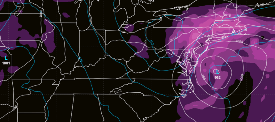
I’m beginning to lean towards a coastal low coming up the coast and either stalling or retrograding a bit before departing. This would put Sunday to Tuesday in a window of a nor’easter. It wouldn’t be a horribly strong nor’easter given the expected low pressure of 992-996mb but the duration of it could be the most noticeable feature. The trend over the last few datasets has been towards this idea with a ridge placed a little further N in E Canada which allows the coastal storm to reach as far N as the NJ/NY area. I’ll be tracking closely and will update accordingly.
In English: Rain moves in by 10pm for most of NJ this evening (Tuesday), falls overnight and clears out by early Wednesday afternoon. A quarter inch of rain seems likely. A half inch to an inch is possible but likely just in localized pockets. Colder breeze picks up Wednesday evening and a colder air mass moves in for Thursday-Friday. Saturday moderates some but looks to stay dry. Then a coastal storm, possibly a Sunday-Tuesday nor’easter, is increasing in likelihood which would mean much-needed significant rainfall, increased winds, beach erosion and unswimmable surf.
Premium Services
KABOOM Club offers ad-free content, inside info forecast discussion, your questions answered, and early storm impact maps and video releases (ahead of the public). At $1.99 per month, it’s an extremely feasible way to show additional support for Weather NJ and you can turn it on and off for however many months you wish. Think of it as a tip jar with perks. Available onFacebook or Patreon.
My Pocket Meteorologist (MPM), in partnership with EPAWA Weather Consulting, offers professional/commercial interests, whose businesses depend on outdoor weather conditions (snow plowing, landscaping, construction, etc.), with hyper-local text message alerts/forecasts from real meteorologists and access to the MPM premium forum—the most comprehensive and technical forecast discussion available for PA and NJ.
Jonathan Carr (JC) is the founder and sole operator of Weather NJ, New Jersey’s largest independent weather reporting agency. Since 2010, Jonathan has provided weather safety discussion and forecasting services for New Jersey and surrounding areas through the web and social media. Originally branded as Severe NJ Weather (before 2014), Weather NJ is proud to bring you accurate and responsible forecast discussion ahead of high-stakes weather scenarios that impact this great garden state of ours. All Weather. All New Jersey.™ Be safe! JC


LOCAL FORECAST | INTERACTIVE RADAR | LATEST NJ WEATHER ALERTS | WEDDING FORECAST| PRIVACY POLICY
© Copyright 2025 Weather NJ LLC. All Rights Reserved.
Some information that can be found on our website is provided by a private weather station and is not an officially recognized station for weather reporting. Though we always strive to achieve accurate reporting for our own use, it is important that you do NOT depend on the data provided here for any purpose.
