

Pre-Christmas Storm Update

Discussion: I wanted to give it through 00Z model data tonight, at least to the GFS run, to confirm the trend that has occurred this weekend and what it means for the December 22-24 storm signal. It’s bad news for snow lovers but I would still expect travel and several other concerns. There are multiple parts to this system so let’s break it down.
First, let’s talk wind. We still have a strong synoptic storm signal with a suggested surface low below 970mb, almost down to 960mb on the latest data. Regardless of where that tracks to, there’s going to be a large wind field correlating to the large tightly packed concentric orientation of isobars. Even if this only verifies as a 980-985mb system, that will likely still result in widespread power outages. So, I would go ahead and expect such due to the expected high winds This Thursday-Saturday. I would expect moderate winds out of the S/SW Thursday night into Friday, then moderate-to-high winds out of the W/NW from Friday night through most of Saturday.
The next most impressive feature is the Arctic front. The latest data has a 1050mb+ Arctic high dropping into the NW US from W Canada. The front side of this high and the storm low will work together to pull down the really cold stuff into the cold sector of the mid-latitude cyclone. This will eventually wrap around the S side of the low and move into New Jersey. A whole new level/gear of cold from the stale Canadian wintry air we’ve seen lately. The Arctic front is expected to race through the tail end of synoptic precipitation. With that said, we could be looking at a flash freeze situation Frida night into Saturday morning. It would also mean rain ending as snow for a short duration, likely as a burst along the Arctic front. So in theory, this system could end white for many. I wouldn’t get any hopes up for significant accumulations. But it could lay down enough of a coating to whiten things up. And I promise you it will not melt in the Arctic air before Christmas Day. So there’s that.
Precipitation could start as early as Thursday afternoon (rain for most of NJ). It will move in from the S from a SE US system. It might start out as snow for NWNJ elevations but will go over to rain for all by Thursday evening. It should then rain on-and-off, moderate-to-heavy at times Thursday night into Friday morning. We might see a break/lull in the precip on Friday before returning later Friday PM. The Arctic cold front then pushes through Friday night into early Saturday morning and winterizes all liquid. That includes changing any rain still falling to snow and freezing all the puddles/freestanding water in areas of poor drainage. Roads with good drainage will likely dry from the cold ripping winds. But basically, if it looks wet Saturday morning, assume it is frozen.
Coastal flooding doesn’t look too bad after the initial Thursday PM SE fetch ahead of the low. That will be during the lower of the two astronomical high tides that day. Typical water in streets that see water in streets a lot. We’ll then see S/SW winds ahead of the front (parallel to coastal NJ) and W/NW winds behind the front (blowout tide?). Perhaps some of extreme SNJ/SWNJ coasts could see some Delaware Bay water push in from the S but that’s about it.
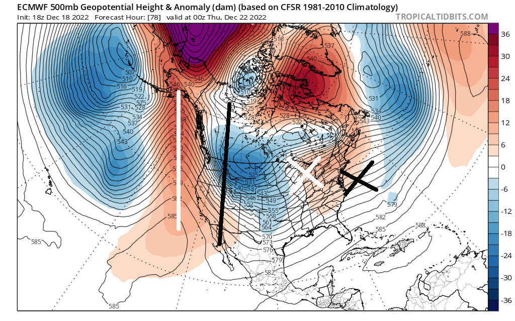
So what happened to the snowier outcome that models were showing? The pattern is favorable for storm development which will still be true despite likely missing NJ with wintry impacts. The jet stream has shifted W. It starts upstream with the trough/upper low between the Aleutians and Hawaii. This EPO area has dug a little more as a trough which affected the neighboring +PNA region just to the E. It pulled that +PNA just offshore of the W US rather than over the W US. This then has further downstream implications by pulling the negative storm trough of interest from the E US to the C/E US. Furthermore, this allows some ridging to pull into the SE US and warm things up and down the E US. So like I said, favorable storm development pattern but shifted W in correlation with the ridge being further W. The below image represents where the +PNA ridge is currently modeled during its most important time (white line) vs where it needs to be to hit NJ with snow. If you then look downstream, it’s about how far W the low is currently modeled (white x) vs where it needs to be for a NJ snowstorm (black x). Almost the same exact distance. We still have 96 hours of data to unfold but it currently looks like a miss for a classic NJ snowstorm. Instead, a mostly rain event with possibly some up-front and ending wintry action.
In English: It will remain on the chilly side (not horribly cold) until rain moves in by Thursday afternoon. It should then rain steady Thursday night into Friday morning before a possible lull on Friday. Rain then likely moves back in later Friday and changes to a brief but possibly heavy period of ending snow (light accumulations possible). We’re then appropriately cold for Christmas thanks to an Arctic cold front and Arctic air mass to follow. Winds, and related power outages, will likely take the headline for this mostly rainy system. The strongest winds should be between Friday PM and Saturday PM. Coastal flooding not looking too bad. The snowier outcome has trended to a rainier outcome. And now that we are within a more confident range, the rainier outcome has solid support. Could it trend back colder a little? Sure, but likely only enough to bring interior/Appalachians more into it. The detailed discussion above covers the whys if you’re interested how it trended over the weekend. But yeah, it’s going to be crappy out from Thursday afternoon through early Saturday morning. You should probably plan around that. Be safe! JC
Premium Services
KABOOM Club offers inside info forecast discussion, your questions answered, and early storm impact maps (ahead of the public). At 99 cents per month, it’s an extremely feasible way to show support.
My Pocket Meteorologist (MPM), in partnership with EPAWA Weather Consulting, offers professional/commercial interests, whose businesses depend on outdoor weather conditions (snow plowing, landscaping, construction, etc.), with hyper-local text message alerts/forecasts and access to the MPM premium forum—the most comprehensive and technical forecast discussion available for PA and NJ.
Jonathan Carr (JC) is the founder and sole operator of Weather NJ, New Jersey’s largest independent weather reporting agency. Since 2010, Jonathan has provided weather safety discussion and forecasting services for New Jersey and surrounding areas through the web and social media. Originally branded as Severe NJ Weather (before 2014), Weather NJ is proud to bring you accurate and responsible forecast discussion ahead of high-stakes weather scenarios that impact this great garden state of ours. All Weather. All New Jersey.™ Be safe! JC


LOCAL FORECAST | INTERACTIVE RADAR | LATEST NJ WEATHER ALERTS | WEDDING FORECAST| PRIVACY POLICY
© Copyright 2026 Weather NJ LLC. All Rights Reserved.
Some information that can be found on our website is provided by a private weather station and is not an officially recognized station for weather reporting. Though we always strive to achieve accurate reporting for our own use, it is important that you do NOT depend on the data provided here for any purpose.
