

Rain and Storms Approaching for Tonight
Discussion: The high pressure, that brought us the beautiful conditions these past few days, is out in the Atlantic Ocean. The SW side of the high’s anti-cyclonic flow is now kicking winds into NJ from the S. You might have noticed the S breeze as well as the overall more humid feel. Therefore, we’re now in the warm sector of an approaching frontal system anchored to a low in SE Canada.
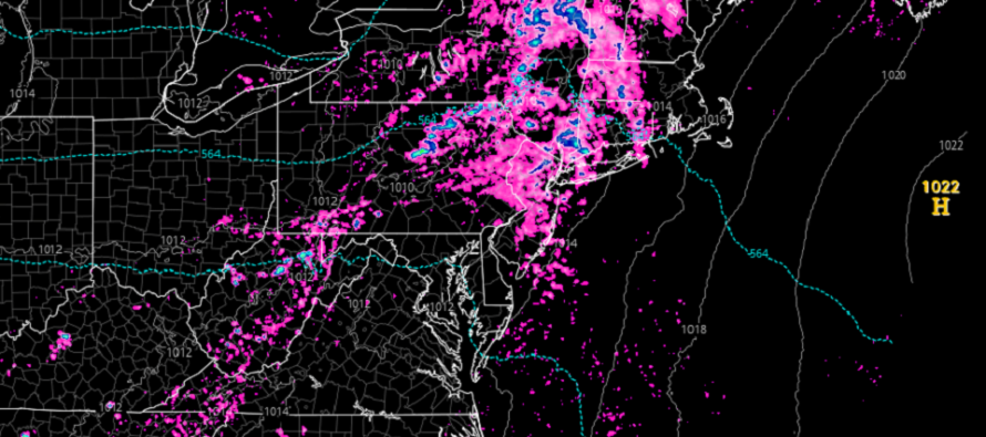
We should remain muggy with clouds here and there today until showers and thunderstorms, associated with a cold front, pass through NJ later tonight. It looks like a general passage window of 8pm-midnight tonight for the showers and thunderstorms to pass through from W to E. As of right now, it doesn’t look like a severe weather outbreak however isolated instances of severe could be possible within the overall strong storm expectation. Expect all the usual suspects (downpours, gusty winds, lightning, and possibly small hail).
Wednesday looks a little drier than it looked a few days ago but still unsettled between the departing front and approaching Thursday morning system. I would expect a mix of sun and clouds with iso showers/storms not off the table.
Thursday morning should start with a warm frontal passage during early AM hours. This should pass through NJ from SW to NE as the low tracks through PA, over extreme NNJ, and into New England. A very close track just to the N/NW of NJ which means a short warm sector and immediately proceeding cold front (by noon). But once that moves out, the rest of Thursday PM and all of Friday look nice.
Model guidance is a little torn on Saturday being the only problematic day of the weekend. The GFS has more of a rainy all-day Saturday. The Euro more of a quick in-and-out Saturday evening. I am currently leaning towards the Euro but in either case, chances are increasing that Saturday will see some form of rain followed by a dry Sunday.
In English: Muggier and breezier today. Rain and storms tonight. Iso activity Wednesday but overall not too wet. Heavy rain/storms Thursday morning with improvement Thursday PM and a nice Friday. Some rain Saturday (still yet TBD) and then a nice Sunday. Hope everyone has a great rest of your Tuesday. Please be safe! JC
Premium Services
KABOOM Club offers inside info forecast discussion, your questions answered, and early storm impact maps (ahead of the public). At a buck per month, it’s an extremely feasible way to show support for JC.
My Pocket Meteorologist (MPM), in partnership with EPAWA Weather Consulting, offers professional/commercial interests, whose businesses depend on outdoor weather conditions (snow plowing, landscaping, construction, etc.), with hyper-local text message alerts/forecasts and access to the MPM premium forum—the most comprehensive and technical forecast discussion available for PA and NJ.
Jonathan Carr (JC) is the founder and sole operator of Weather NJ, New Jersey’s largest independent weather reporting agency. Since 2010, Jonathan has provided weather safety discussion and forecasting services for New Jersey and surrounding areas through the web and social media. Originally branded as Severe NJ Weather (before 2014), Weather NJ is proud to bring you accurate and responsible forecast discussion ahead of high-stakes weather scenarios that impact this great garden state of ours. All Weather. All New Jersey.™ Be safe! JC


LOCAL FORECAST | INTERACTIVE RADAR | LATEST NJ WEATHER ALERTS | WEDDING FORECAST| PRIVACY POLICY
© Copyright 2026 Weather NJ LLC. All Rights Reserved.
Some information that can be found on our website is provided by a private weather station and is not an officially recognized station for weather reporting. Though we always strive to achieve accurate reporting for our own use, it is important that you do NOT depend on the data provided here for any purpose.
