

Rain and Storms to Break Heat Wave
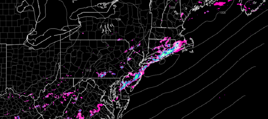
Discussion: Upper levels appear zonal this week as the Bermuda high remains parked. A low tracking through SE Canada, however, will drag a cold front through NJ by Tuesday morning which will bring some relief and break the heat wave for at least a few days. The rest of the week into the weekend looks typical for NJ in July…warm, humid, mostly sunny but with unsettled afternoon-evenings. An upper-level disturbance looks to thwart the post-frontal relief by Wednesday night but could bring some rainfall with it into Thursday morning. Otherwise Friday would be the next chance for rain from another passing disturbance. For now all eyes are on the approaching rain/storm front for later today. As with other frontal systems this year, today/tonight’s front could be broken meaning some areas miss out on the rain/storm activity while others get hit. I know many are concerned about the developing drought. Even if you get hit tonight, it won’t be anything considered drought-busting. But some locations could see severe criteria thunderstorms. The rain/storm front is already into NWNJ now and will slowly push through NJ for the remainder of today/tonight. It should cross over 95 by late-afternoon and then through SENJ by about 8-10pm tonight. Again…a broken front of rain and storms with hit-or-miss potential.
Monday (July 25) high temperatures should reach the upper-80s/lower-90s before the rain/storm front pushes through. Expect a humid feel with clouds increasing ahead of rain/storms. Rain and possible storms should push through NWNJ this early afternoon, cross over the I-95 corridor later this afternoon, then eventually push through SENJ by this evening. Storms could reach severe criteria on a localized/isolated basis. Winds should be gradually transition from light to breezy out of the S/SW ahead of the front. Overnight lows should range from 60-70 from elevations to coasts.
Tuesday (July 26) high temperatures should max out in the 80s. Skies should be mixed with sun and clouds with a less humid feel. Winds should be light out of the W/NW. Overnight lows should fall into the 60s for most areas. Coastal regions could hang closer to 70.
Wednesday (July 27) high temperatures should reach the mid-to-upper 80s for most. Skies should be mixed with sun and clouds with humidity returning by afternoon. Winds should be light out of the S/SE. Overnight lows should range from mid-60s to mid-70s from elevations to coasts. Cannot rule out an overnight pop-up shower or t-storm.
Thursday (July 28) high temperatures should break 90 for many away from the ocean. Skies should be mostly sunny but with a hazy, hot, and humid feel. Super small chance of an isolated pop-up off the sea breeze front. Winds should be light out of the SW. Overnight lows should range from mid-60s to mid-70s from elevations to coasts.
Friday (July 29) high temperatures should reach the mid-to-upper 80s for most areas. Skies should be mostly cloudy with a humid feel. Showers and thunderstorms should be around. Winds should be light out of the W/SW. Overnight lows should range from 60-70 from elevations to coasts.
An early look at the weekend indicates more of the same. Highs in the 80s. Lows 60-70. Skies mixed with a humid feel and isolated pop-up chances. Everyone have a great week and please be safe! JC
Premium Services
KABOOM Club offers inside info forecast discussion, your questions answered, and early storm impact maps (ahead of the public). At a buck per month, it’s an extremely feasible way to show support.
My Pocket Meteorologist (MPM), in partnership with EPAWA Weather Consulting, offers professional/commercial interests, whose businesses depend on outdoor weather conditions (snow plowing, landscaping, construction, etc.), with hyper-local text message alerts/forecasts and access to the MPM premium forum—the most comprehensive and technical forecast discussion available for PA and NJ.
Jonathan Carr (JC) is the founder and sole operator of Weather NJ, New Jersey’s largest independent weather reporting agency. Since 2010, Jonathan has provided weather safety discussion and forecasting services for New Jersey and surrounding areas through the web and social media. Originally branded as Severe NJ Weather (before 2014), Weather NJ is proud to bring you accurate and responsible forecast discussion ahead of high-stakes weather scenarios that impact this great garden state of ours. All Weather. All New Jersey.™ Be safe! JC


LOCAL FORECAST | INTERACTIVE RADAR | LATEST NJ WEATHER ALERTS | WEDDING FORECAST| PRIVACY POLICY
© Copyright 2026 Weather NJ LLC. All Rights Reserved.
Some information that can be found on our website is provided by a private weather station and is not an officially recognized station for weather reporting. Though we always strive to achieve accurate reporting for our own use, it is important that you do NOT depend on the data provided here for any purpose.
