

Rain and Storms to Break the Humidity
Discussion: It’s time for a cold front to push all this humid storminess out of the region. It’s going to be a process that starts tonight and ends Friday morning. Let’s dive into it…
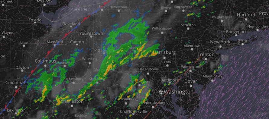
The surface map (shown above) indicates two features worth talking about. First is the boundary draped through Cincinnati and Cleveland (red and blue line). This is what will eventually push through NJ from NW to SE. Second is a surface trough seen close to parallel with the I-95 corridor running through DC, Baltimore, Philly, and Trenton. Since this trough parallels the Appalachian Mountain peaks, it’s probably safe to assume it’s a leeward trough (pressure drops linearly after air flow expands on the leeward side of the mountains). This linear pressure drop allows for lifting that helps form showers and thunderstorms. We’re seeing this now (as of 2pm Tuesday). The radar view also indicated a decent amount of shower and thunderstorm formation between the trough and the boundary. I expect this to all push through NJ for the rest of today/tonight/Wednesday morning in the form of heavy downpours, strong/severe winds, frequent lightning, and as always the lesser non-zero chance of isolated tornadoes. The primary window of impact for the most concentrated cluster of thunderstorms should hit NJ tonight between about 7-10pm W to E. Less intense action should surround this window earlier today and then later overnight/Wednesday. The main event window tonight should zap a lot of energy out of the atmosphere so that all remaining rain/storms through Wednesday noonish become less intense.
Wednesday should start in the middle of rain and storms. It might be late-Wednesday morning/early-Wednesday afternoon before the last remnant rain/storm activity clears the NJ coast out to sea. We still have to allow for some isolated pop-up cells Wednesday evening into early Thursday morning primarily near the warmest (most destabilized) points of the I-95 corridor. Very isolated micro stuff.
By sunrise Thursday, there should be a noticeable drop in humidity but not yet the total relief that’s coming. Dew points will go from 70s to 60s with sun and clouds with mid-80s temps. We will have a trough moving into place which carries its own upper level disturbance potential mainly late-Thursday night/early Friday morning. Within this period, isolated-to-scattered showers and thunderstorms are possible starting from NWNJ and pushing down towards SENJ. Not a bid deal, they will fizzle out by the time they reach SENJ, and it happens overnight.
Friday (July 4) is going to be most impressive feel of relief. No rain. Sunny skies. Low humidity (dew points down into the upper-50s). Temps a few degrees on either side of 80. I imagine Friday morning will be one of those few days that New Jersey feels like the Bahamas. Excellent news for outdoor BBQs/concerts/activities during the day and then for firework shows at night.
The weekend looks rain-free as well through Sunday. It’s an amazing 4th of July weekend forecast honestly. Humidity will gradually return as will warmer temperatures. But it shouldn’t return to the oppressive humidity until early next week. Saturday should reach similar temperatures as Friday but with dew points back in the 60s. Sunday might reach the mid-to-upper 80s with dew points still holding in the 60s. Monday then is expected to see dew points in the 70s return (sticky).
In English: Expect a muggy and stormy night tonight (Tuesday). Isolated-to-scattered showers and thunderstorms will continue to push through this afternoon/early evening. The best chance for butt-kickers occurs tonight from about 7pm to 10pm (they will be moving W to E at an angle parallel to I-95/NJTP). After that, showers and thunderstorms will continue until about noon Wednesday. Wednesday night through the entire weekend looks dry with the exception of a few isolated shower/storm possibilities later Wednesday and Thursday evenings. Friday through Sunday looks immaculate for July 4th outdoor activities (daytime BBQs and nighttime fireworks). Friday should feel like a day in the Bahamas with a nice breeze. Saturday just a little warmer/more humid. Sunday even warmer and more humid. But the horrendous muggy feel won’t return until Monday at the earliest. The detailed holiday weekend outlook will be out on Thursday but I do not expect a lot to change. It’s a pretty straightforward cold frontal passage with nice conditions behind such. Have a great rest of your Tuesday and please be safe! JC
Premium Services
KABOOM Club offers ad-free content, inside info forecast discussion, your questions answered, and early storm impact maps and video releases (ahead of the public). At $1.99 per month, it’s an extremely feasible way to show additional support for Weather NJ and you can can turn it on and off for however many months you wish. Think of it as a tip jar with perks. The public eventually sees all info discussed in premium areas. Available onFacebook or Patreon.
My Pocket Meteorologist (MPM), in partnership with EPAWA Weather Consulting, offers professional/commercial interests, whose businesses depend on outdoor weather conditions (snow plowing, landscaping, construction, etc.), with hyper-local text message alerts/forecasts and access to the MPM premium forum—the most comprehensive and technical forecast discussion available for PA and NJ.
Jonathan Carr (JC) is the founder and sole operator of Weather NJ, New Jersey’s largest independent weather reporting agency. Since 2010, Jonathan has provided weather safety discussion and forecasting services for New Jersey and surrounding areas through the web and social media. Originally branded as Severe NJ Weather (before 2014), Weather NJ is proud to bring you accurate and responsible forecast discussion ahead of high-stakes weather scenarios that impact this great garden state of ours. All Weather. All New Jersey.™ Be safe! JC


LOCAL FORECAST | INTERACTIVE RADAR | LATEST NJ WEATHER ALERTS | WEDDING FORECAST| PRIVACY POLICY
© Copyright 2025 Weather NJ LLC. All Rights Reserved.
Some information that can be found on our website is provided by a private weather station and is not an officially recognized station for weather reporting. Though we always strive to achieve accurate reporting for our own use, it is important that you do NOT depend on the data provided here for any purpose.
