

Rain and Thunderstorms Approaching
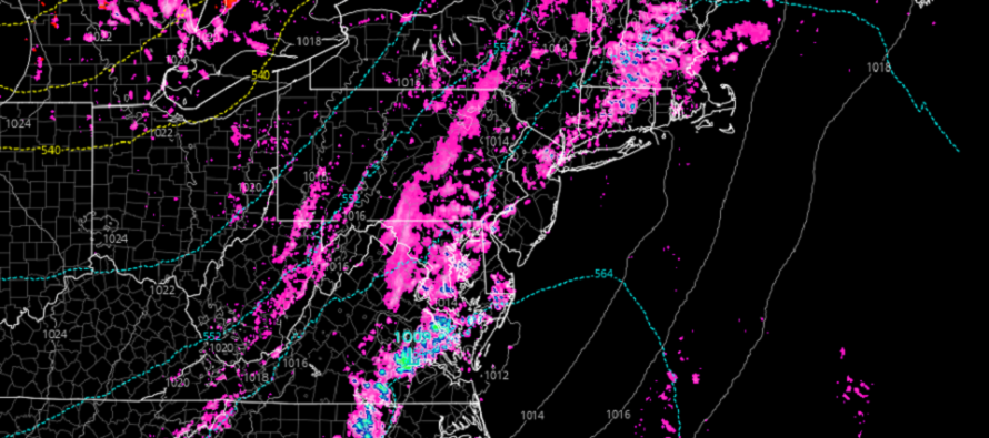
Discussion: Some CNJ/SNJ locations have pushed well into the 70s today while most of NNJ remains in the low-to-mid 60s. Today is a warm sector day meaning S/SW flow over NJ ahead of an approaching cold front. Temperature and humidity likes to ramp up in the immediate warm sector. Google the Norwegian Cyclone Model if you’d like to learn more about how fronts and air masses feed into mid-latitude cyclones. For this evening/overnight, we have the immediate warm sector and approaching cold front feeding into a mid-latitude cyclone.
I imagine tonight will be a mostly non-severe frontal passage but that’s not to rule out isolated instances of severe criteria being met. SNJ spiked a few degrees warmer than expected given the unobstructed diurnal surface heating setup. The sun heats the surface. Heat wants to rise into cold. There’s cold aloft. The rising motion brings moist surface air upwards to the point of condensation. You all see the cumulus and even cumulonimbus clouds build and dump water back to the earth. The rising and falling air associated creates friction and lightning occurs. And so on. So I expect all of this but just not seeing a severe outbreak from it where wind gusts are commonly reaching 58mph or above. You might see some hail meet the criteria but again, likely localized/isolated. I would say SENJ has a greater chance of seeing better storms given the instability that has built.
The rain, and any thunderstorms associated, should push through between now and later tonight. NWNJ first (this afternoon). The I-95 corridor next (late-afternoon/early-evening). Lastly the ECNJ/SENJ coast (early-to-late evening). Following the frontal precip and storm activity will be W/NW winds as the cold front pushes through between this evening and tomorrow morning.
A colder Wednesday through Friday morning is then expected as the trough’s coldest air mass settles in over NJ and the general Mid-Atlantic US. Thursday morning looks like the coldest point. With that said, Wednesday night into Thursday morning and Thursday night into Friday morning should produce frost criteria. Some NWNJ elevations might even approach/dip-below freezing if radiational cooling is allowed (need light winds and clear skies overnight).
The good news is that Thursday or Friday could be the last day of spring where temps fail to escape the 50s. Once we’re into May (next week), even the colder (below-average expected) days should still make it into the 60s from thereon. Basically, we’re getting to a time of year where even below-average temperatures still feel nice. Climatology. We could still be cursed with troughs and back-door cold fronts but the overall trend will be each day getting warmer.
I do think this will be the last time I say the word snow until the 2022-2023 snow season opens back up (sometimes as early as October but usually by early December).
In English: We have some rain and possibly thunderstorms approaching for tonight. Severe conditions are possible but non-severe seems more probable with the overall passing cold front. Temps then dive for Wednesday and Thursday (highs in the 50s lows in frost territory). The weekend is looking pretty good…still below average in temperature but low-to-mid 60s in the sun will feel great. Next week looks to start with a transient warm snap but how long it sticks around is yet TBD. Be safe! JC
Premium Services
KABOOM Club is more for the snow lover or weather nerd who needs inside info with early forecast discussion and storm impact maps (ahead of the public). It’s a bit more complex than what the public sees but offers the “In English” with it. It’s also a way to support Weather NJ with a 99-cent per month contribution.
My Pocket Meteorologist offers commercial interests, whose businesses depend on outdoor weather conditions (snow plowing, landscaping, construction, etc.), with hyper-local text message forecasts and access to the My Pocket Meteorologist premium forum. This information is the most complex analysis available as needed by the outdoor commercial sector.
Jonathan Carr (JC) is the founder and sole operator of Weather NJ, New Jersey’s largest independent weather reporting agency. Since 2010, Jonathan has provided weather safety discussion and forecasting services for New Jersey and surrounding areas through the web and social media. Originally branded as Severe NJ Weather (before 2014), Weather NJ is proud to bring you accurate and responsible forecast discussion ahead of high-stakes weather scenarios that impact this great garden state of ours. All Weather. All New Jersey.™ Be safe! JC


LOCAL FORECAST | INTERACTIVE RADAR | LATEST NJ WEATHER ALERTS | WEDDING FORECAST| PRIVACY POLICY
© Copyright 2025 Weather NJ LLC. All Rights Reserved.
Some information that can be found on our website is provided by a private weather station and is not an officially recognized station for weather reporting. Though we always strive to achieve accurate reporting for our own use, it is important that you do NOT depend on the data provided here for any purpose.
