

Rain and Wind Never Bothered me Anyway.
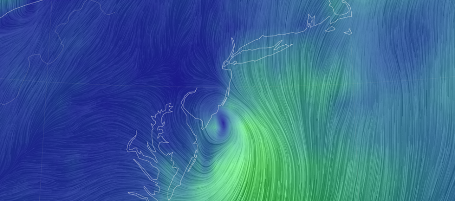
Discussion: Remnants of a once Hurricane Elsa will take a pass at New Jersey this Thursday night into Friday morning. Else originally entered the W Caribbean/Lesser Antilles, crossed some of the Caribbean Sea and tucked up into SW Florida. It’s not a historic or even major hurricane. It’s actually weakening quite a bit. Elsa, or her remnants, will now track up the E US coast and find the weakness between a ridge just offshore and an upper-level shortwave to the W of NJ closer to the Great Lakes. The 500mb streamline flow tells me that the storm will take a S/SW to N/NE track over NJ. The upper-level energy to the W of NJ will try to hug it W while the offshore ridge will offer no clear out to sea escape plan. Therefore, Elsa’s remnants are likely coming to NJ Thursday PM-Friday AM.
In general, the rain and wind from Elsa’s remnants will be stuff we’ve seen many times before. No big deal. However at the meso/micro scale level, Elsa’s remnants could cause some problems. Since the low is expected to pass over or just inland, the SENJ/ECNJ coast will likely take the strongest winds to the face. We’re talking strong nor’easter like winds (25-30mph sustained, gusts to 50mph), not catastrophic hurricane strength winds. Again, this is for the widespread and general expectation.
For meso/micro instances, the N and NE quadrants, of even fizzling tropical systems, can cause problems. You will likely have S flow at the surface underneath W/SW flow at the low-mid levels. This can create vertical shear capable of producing EF-0 to EF-2 tornadoes. We saw some of this last year with Isaias.
So I think most people will experience a general nor’easter like system between late-Thursday night and Friday morning (out of here by Friday afternoon). I think some, at the localized level, will experience tornados and coastal flooding, especially SENJ/ECNJ areas. Away from the ocean, especially NW of I-95), the primary threat should be primarily heavy rain. I’ll be tracking this closely in the next few days as Elsa’s remnants approach.
In English: Elsa’s remnants should deliver run-of-mill rain and wind to NJ this Thursday night into Friday morning…FOR MOST. FOR SOME…small tornadoes and localized embedded thunderstorms could produce a more severe outcome. I think SENJ will be the most impacted from this with NWNJ being the least. Let’s see how the data looks tomorrow. Be safe! JC
Download the free Weather NJ mobile app on Apple or Android. It’s the easiest way to never miss Weather NJ content. Our premium services go even further above and beyond at the hyper-local level.
Jonathan Carr (JC) is the founder and sole operator of Weather NJ, New Jersey’s largest independent weather reporting agency. Since 2010, Jonathan has provided weather safety discussion and forecasting services for New Jersey and surrounding areas through the web and social media. Originally branded as Severe NJ Weather (before 2014), Weather NJ is proud to bring you accurate and responsible forecast discussion ahead of high-stakes weather scenarios that impact this great garden state of ours. All Weather. All New Jersey.™ Be safe! JC


LOCAL FORECAST | INTERACTIVE RADAR | LATEST NJ WEATHER ALERTS | WEDDING FORECAST| PRIVACY POLICY
© Copyright 2026 Weather NJ LLC. All Rights Reserved.
Some information that can be found on our website is provided by a private weather station and is not an officially recognized station for weather reporting. Though we always strive to achieve accurate reporting for our own use, it is important that you do NOT depend on the data provided here for any purpose.
