

Rain and Wind System Moves Out
Storm Synopsis: Last week, a tropical disturbance formed a few hundred miles E of Florida. The upper low associated with the disturbance formed due south of an upper-level ridge centered over SE Canada. The ridge extended higher geopotential heights southward through New Jersey which created a steering current scenario that took the tropical cyclone N/NW into coastal North Carolina. Prior to NC landfall, the system intensified to a strong Tropical Storm designation, named Ophelia, with sustained winds just 5mph short of category 1 hurricane classification.
Ophelia quickly dissipated after NC landfall early Saturday morning but transitioned into an extra-tropical cyclone. This was evident by the large expansion on the north side of the wind field surrounding the center of circulation and also by the frontal boundary formation associated with clashing air masses of differing temperature profiles. Basically, Ophelia transitioned into a mid-latitude cyclone that we typically expect to bring nor’easters to the Jersey Shore. Satellite observations further confirmed this by the “comma head” appearance of the system formed by the multiple conveyor belts reflecting the Norwegian Cyclone Model as we know it.
Early Saturday morning, the north side of the precipitation shield pushed into southern New Jersey along with correlating cyclonic winds off the ocean. Periods of heavy rainfall fell across New Jersey on Saturday with most of the higher winds staying along the immediate coast. Onshore ocean winds push marine air that is denser onto the mainland. This forces the ocean winds to dive into the surface and dissipate inland. This is why the immediate coastal areas were gusting 40-50mph while areas away from the ocean saw lesser winds. Saturday eventually saw a lull in the precipitation, but it was a little later than expected. It occurred late-afternoon into evening rather than early afternoon until early evening. Regardless, the precipitation picked back up Saturday night through much of Sunday as winds slowly relaxed. The early Saturday afternoon high tide was the highest of the water levels throughout this storm. Images and video were shared on social media showing the ocean right up to the dunes on Long Beach Island.
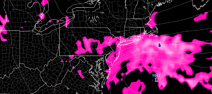
Today (Monday), we have the remnant center of circulation over/departing SE NJ. The system tracked N/NW through NC, E VA, and MD and is now slowly drifting E out to sea over NJ. It was the ridging to our north that forced the system to stop its northward progression and drift east. This is why there is an ominous calming today of the atmosphere. The low is overhead. A bit later today, the low will push further east out to sea and we’ll start to see onshore NE winds again from the NW side of the remnant circulation. The upper low is barely strong enough to support the surface low at this point, but just enough to bring more rain and coastal winds to the Jersey Shore Monday into Tuesday. By Tuesday afternoon/evening, all rain and wind should be far enough offshore for NJ to finally start clearing out.
Forecast Discussion: Per the above storm synopsis, today and tomorrow will remain unsettled with the remnant low nearby. I don’t expect a sustained washout during this time but rather on-and-off periods of scattered showers. Rainfall should be more of a misty/light rain situation rather than a “thunderstorm-like downpours.” As the low gets offshore and to the SE of NJ on Tuesday, high pressure will move into SE Canada/NE US and reform a tight lateral pressure gradient through NJ. This will mean that onshore winds pick up again in the Monday night-Tuesday period. This expected second storm surge on Tuesday (Saturday being the first) will re-introduce coastal flooding to the Jersey Shore with the highest tidal concerns occurring late Tuesday afternoon. Tidal concerns should subside Tuesday night into Wednesday. Even though the onshore winds are expected to relax by Wednesday morning, onshore winds should continue for the rest of this week meaning more clouds than sun and rough surf. As of right now, it looks like conditions improve for the weekend but we’ll revisit that later this week.
In English: The worst of the storm occurred for NJ on Saturday but remnants are still with us through Tuesday PM. After a lull today, expect on-and-off periods of misty/light rain, breezy winds (gustier near coast), and more coastal flooding (especially Tuesday PM) to resume. Rain and higher winds should then end by Tuesday PM/Wednesday AM but lighter onshore winds should produce cooler and cloudier conditions Wednesday through Friday. The weekend looks better from this forecast range but let’s revisit in a few days. Have a great week and please be safe! JC
Premium Services
KABOOM Club offers inside info forecast discussion, your questions answered, and early storm impact maps (ahead of the public). At 99 cents per month, it’s an extremely feasible way to show support.
My Pocket Meteorologist (MPM), in partnership with EPAWA Weather Consulting, offers professional/commercial interests, whose businesses depend on outdoor weather conditions (snow plowing, landscaping, construction, etc.), with hyper-local text message alerts/forecasts and access to the MPM premium forum—the most comprehensive and technical forecast discussion available for PA and NJ.
Jonathan Carr (JC) is the founder and sole operator of Weather NJ, New Jersey’s largest independent weather reporting agency. Since 2010, Jonathan has provided weather safety discussion and forecasting services for New Jersey and surrounding areas through the web and social media. Originally branded as Severe NJ Weather (before 2014), Weather NJ is proud to bring you accurate and responsible forecast discussion ahead of high-stakes weather scenarios that impact this great garden state of ours. All Weather. All New Jersey.™ Be safe! JC


LOCAL FORECAST | INTERACTIVE RADAR | LATEST NJ WEATHER ALERTS | WEDDING FORECAST| PRIVACY POLICY
© Copyright 2026 Weather NJ LLC. All Rights Reserved.
Some information that can be found on our website is provided by a private weather station and is not an officially recognized station for weather reporting. Though we always strive to achieve accurate reporting for our own use, it is important that you do NOT depend on the data provided here for any purpose.
