

Rain and Windstorm Approaching
Discussion: The colder air mass is finished and most likely so are snowstorm chances until we approach Winter 2024-2025. New Jersey will now see a rain and wind event tomorrow (Saturday) which will start the transition towards a milder pattern by mid-next-week.
Saturday is more of a rainstorm statewide but a rain and windstorm for the ocean-facing coasts and immediate ECNJ/SENJ coastal areas. There will still be some stronger winds away from the ocean but not as intense as it will get along the immediate ECNJ/SENJ coasts. Let’s break down the individual impacts:
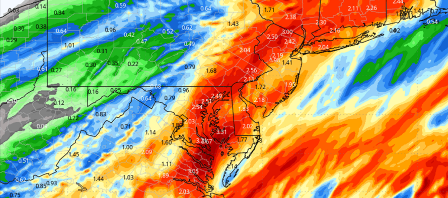
Rain: Rain should begin falling in NNJ/NWNJ first anytime between now and about 3-4am. There’s a chance for some mixed precipitation for the highest NWNJ elevations overnight but no stickage and likely sleet with a quick changeover to rain. The rest of NJ (99%) will be all rain. Rain should fill in the rest of NJ between 4-6am Saturday morning and fall steady, heavy at times, through about 8pm Saturday night. Flash flooding is very possible, especially areas with typically poor drainage. 1-2 inches of rain is a good bet widespread throughout NJ. 3-4 inches of rain is not off the table but would be more localized and scattered.
Wind: Most of NJ is currently tranquil wind-wise. SENJ should notice winds picking up first by about 4am Saturday morning (20-30mph gusts out of SE). By noon, the increased winds should spread further up the coast. It’s possible areas along and NW of 95 stay sort of tranquil during this initial wind phase. But the ECNJ/SENJ coast should really crank from noon to about 6 or 7pm when 40-60mph gusts are possible off the ocean. By 8pm the rain should be exiting the coast with the frontal boundary and all of New Jersey should then see NW winds gusting 30-40mph overnight into Sunday morning.
Coastal Flooding: Saturday should only feature minor coastal flooding at best. The storm is a quick-mover and never allows onshore flow to lock in any one direction for long. Once the storm passes NJ, then winds are NW and will help push water away from the coast. It’s really just the 4am to 6pm period to watch for onshore winds and low tide falls right in the middle of the greatest wind surge (early afternoon). So, for Saturday, just routine run-of-mill coastal flooding up and down the ECNJ/SENJ coasts from a quick-moving ocean storm. There’s actually a greater risk for coastal flooding Sunday night through all of Monday IMO as the low stalls a bit offshore and provides more of a prolonged fetch. I’ll be watching this closely and I think I pointed this idea out earlier this week.
Wildcards: Most likely, this is just another rain and wind event that we’ve seen many times before. One wildcard could be thunderstorms embedded within this system. This could allow for severe criteria winds. Another wildcard could be localized areas seeing more than 4 inches of rainfall. The atmosphere seems juiced so I wouldn’t be shocked if both wildcards occur. But again, the more reasonable expectation widespread is just another rain and wind event.
In English: Rain and wind are approaching New Jersey and will likely produce a washout Saturday. ECNJ/SENJ coasts will see the strongest winds during the day Saturday (gusts to 60mph) while areas away from the ocean see less wind. Rain will be widespread throughout NJ and will confidently dump 1-2 inches of rainfall with 3-4 inches+ not off the table. Thunderstorms, flash flooding, and coastal flooding are all possible. The storm arrives anytime after midnight tonight and tapers off by 8pm Saturday evening with Saturday afternoon likely the peak of it. Saturday night into Sunday should feature stiff NW winds for all of NJ. Sunday then looks dry and windy behind the storm. Next week then gradually builds back into the 60s for high temps. Have a great night and please be safe! JC
Premium Services
KABOOM Club offers inside info forecast discussion, your questions answered, and early storm impact maps (ahead of the public). At a buck per month, it’s an extremely feasible way to show support.
My Pocket Meteorologist (MPM), in partnership with EPAWA Weather Consulting, offers professional/commercial interests, whose businesses depend on outdoor weather conditions (snow plowing, landscaping, construction, etc.), with hyper-local text message alerts/forecasts and access to the MPM premium forum—the most comprehensive and technical forecast discussion available for PA and NJ.
Get your KABOOM Inside Out pajamas and more at the KABOOM shop!
Jonathan Carr (JC) is the founder and sole operator of Weather NJ, New Jersey’s largest independent weather reporting agency. Since 2010, Jonathan has provided weather safety discussion and forecasting services for New Jersey and surrounding areas through the web and social media. Originally branded as Severe NJ Weather (before 2014), Weather NJ is proud to bring you accurate and responsible forecast discussion ahead of high-stakes weather scenarios that impact this great garden state of ours. All Weather. All New Jersey.™ Be safe! JC


LOCAL FORECAST | INTERACTIVE RADAR | LATEST NJ WEATHER ALERTS | WEDDING FORECAST| PRIVACY POLICY
© Copyright 2026 Weather NJ LLC. All Rights Reserved.
Some information that can be found on our website is provided by a private weather station and is not an officially recognized station for weather reporting. Though we always strive to achieve accurate reporting for our own use, it is important that you do NOT depend on the data provided here for any purpose.
