

Rain, possibly storms, approaching SNJ
Discussion: For this week, we’ll have mostly NW upper-level flow coming off the ridge that is currently establishing over the C US. The NW flow will be the result of the top of the ridge combining a split flow pattern into the E US. This kind of setup traditionally produces lower temperatures (relative to average) but stormier/unsettled conditions.
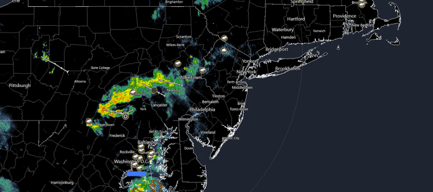
Today (Tuesday) we have the first disturbance approaching from the W/NW. You should notice that humidity is up from yesterday (Monday) with the unsettled S winds. Currently the best returns on radar (moderate-to-heavy rain) are in SCPA moving into SEPA and pushing towards SNJ. I see some lighter stuff is already into NNJ but nothing significant. NNJ should clear completely in a few hours. CNJ a bit longer. But it appears that today’s best storm dynamics are going to cross SNJ between about 4-8pm (from W/NW to E/SE). For this area, expect downpours, higher winds, and a good chance of embedded lightning.
The frontal boundary should then push to the S of NJ for Wednesday. While this should keep most rain and storms to the S of NJ, it will still allow NJ to become warm (80-90) with lingering elevated humidity making it feel even hotter.
Thursday looks like the next chance for rain and storms primarily during PM hours maybe a little into Friday AM. High pressure should then clear everything out and allow for a mostly clear and dry Friday afternoon through the weekend—highs near-80 and lows near-60. We can thank a progressive trough for that once this week’s more zonal pattern breaks and jams up. But given that the weekend could be under trough influence, you can never rule out some friendly clouds which is why I say mostly clear.
In English: Rain, possibly thunderstorms, should push through SNJ later today (between 4-8pm from W/NW to E/SE). For now some lighter activity is falling in NJ and will soon fall in CNJ. The most favored area of NJ for the storm action is SNJ. We’re then warm and humid but mostly clear Wednesday followed by an unsettled Thursday. Once that moves out (by Friday morning), the weekend looks great (warm, mostly clear and dry).
Premium Services
KABOOM Club offers inside info forecast discussion, your questions answered, and early storm impact maps (ahead of the public). At a buck per month, it’s an extremely feasible way to show support.
My Pocket Meteorologist (MPM), in partnership with EPAWA Weather Consulting, offers professional/commercial interests, whose businesses depend on outdoor weather conditions (snow plowing, landscaping, construction, etc.), with hyper-local text message alerts/forecasts and access to the MPM premium forum—the most comprehensive and technical forecast discussion available for PA and NJ.
Jonathan Carr (JC) is the founder and sole operator of Weather NJ, New Jersey’s largest independent weather reporting agency. Since 2010, Jonathan has provided weather safety discussion and forecasting services for New Jersey and surrounding areas through the web and social media. Originally branded as Severe NJ Weather (before 2014), Weather NJ is proud to bring you accurate and responsible forecast discussion ahead of high-stakes weather scenarios that impact this great garden state of ours. All Weather. All New Jersey.™ Be safe! JC


LOCAL FORECAST | INTERACTIVE RADAR | LATEST NJ WEATHER ALERTS | WEDDING FORECAST| PRIVACY POLICY
© Copyright 2026 Weather NJ LLC. All Rights Reserved.
Some information that can be found on our website is provided by a private weather station and is not an officially recognized station for weather reporting. Though we always strive to achieve accurate reporting for our own use, it is important that you do NOT depend on the data provided here for any purpose.
