

Rain Storm Approaching
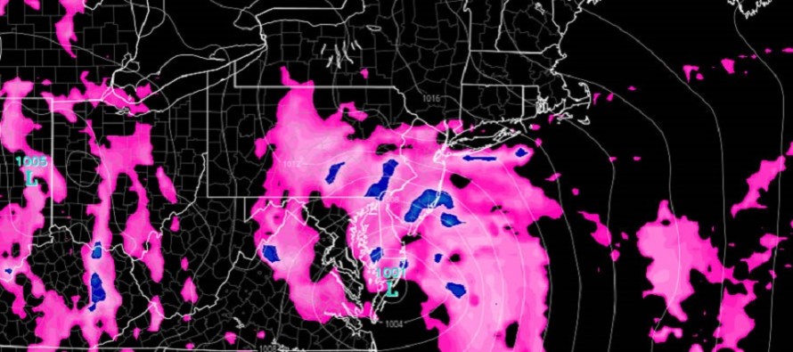
Discussion: The upper-level low is fully closed off over the S Great Lakes as an overall upper-level negatively-tilted trough interacts with our coastal system. This interaction is slightly stronger in real-time observation than modeled leading into this event. I think this is going to produce a coastal low track further W along or even W of the Delaware River (into EPA). The surface coastal low is simply being yanked further W by a more robust phase.
This ultimately means that winds, which should become gusty at times, will rock from E to SE to S as the low passes through New Jersey latitude. Typically a coastal produces winds that rock from E to NE to N however you need the cyclonic circulation E of the coastline for that to happen. This system is basically going to rip a warm front through that should feel like the finer misty tropical drenching rain. It has a unique characteristic compared to the larger heavy drops that normally fall in New Jersey. If you’ve ever experienced tropical storm or hurricane rain, you know what I’m talking about.
The stronger phase could also tweak the timing of peak rain and wind. On the latest short-range model guidance, I’m seeing two primary bands of rain. The first moves through NJ from S to N between noon and 5pm. The second main band looks to push through NJ from S to N between 5pm and the early AM hours of Sunday. This second band looks to be the most convective which means a better chance for embedded thunderstorms. The rain should then end from S to N in the form of a dry slot just S of the greatest band convection.
The flooding concern comes mostly in the form of flash flooding (for most of NJ). 1-3 inches of rainfall, maybe more for ENJ, is expected to fall between now and tomorrow morning. This could ramp up creek and stream activity. For coastal regions, especially barrier islands that drain slower, you will also deal with an elevated Saturday evening high tide related to onshore flow surge. This could inhibit drainage of heavy rainfall and quickly build up water in the streets. Sunday still looks drier but the chance for widely-scattered showers is still on the table.
In English: Expect widespread rainfall to move into New Jersey from S to N today. The first few showers are just starting to move into Cape May now. The rain line should slowly push northward and reach into CNJ/NNJ by 5pm. The rain should then end between 8pm and 3am from S to N. During the period between all areas should expect 1-3 inches of rainfall (possibly more for ENJ) and elevated winds. The coast will see the brunt of the wind with gusts possibly exceeding 40mph. Sustained winds should be in the 20-30mph range for most maybe higher along the coast. The real wildcard here are any embedded thunderstorms within the tropical-like rain bands. We’ll have to play that by ear in live observations. I’ll be out and about later. Might do a livestream if anything is livestream-worthy. Either way I’ll keep you updated. Have a great day and please be safe! JC
Jonathan Carr (JC) is the founder and sole operator of Weather NJ, New Jersey’s largest independent weather reporting agency. Since 2010, Jonathan has provided weather safety discussion and forecasting services for New Jersey and surrounding areas through the web and social media. Originally branded as Severe NJ Weather (before 2014), Weather NJ is proud to bring you accurate and responsible forecast discussion ahead of high-stakes weather scenarios that impact this great garden state of ours. All Weather. All New Jersey.™ Be safe! JC


LOCAL FORECAST | INTERACTIVE RADAR | LATEST NJ WEATHER ALERTS | WEDDING FORECAST| PRIVACY POLICY
© Copyright 2026 Weather NJ LLC. All Rights Reserved.
Some information that can be found on our website is provided by a private weather station and is not an officially recognized station for weather reporting. Though we always strive to achieve accurate reporting for our own use, it is important that you do NOT depend on the data provided here for any purpose.
