

Rain, Wind, and Storms Approaching
Discussion: A very temporary ridge is currently over the E US correlating with S/SW flow at the lower levels. That’s why much of NJ is still in the 50s at 11pm. Some even in the lower-60s. It’s going to remain mild overnight and into tomorrow (Saturday) until eventually a cold front pushes through and welcomes in a period of NW flow.
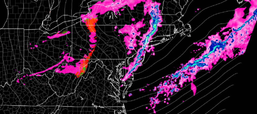
We have another strong low bringing snow to the Great Lakes tonight and tomorrow before tracking over SE Canada and into the N Atlantic by Sunday. This low will drag a series of linear/frontal energy pieces through NJ between early Saturday morning and later Saturday afternoon.
The first piece will be a warm front attached to the low. This should be the kindest of the three with mostly scattered showers, maybe a rumble or two. The warm front should push through just after midnight tonight. The second piece will be more of a pre-frontal trough but tightly wound behind the warm front. This should be more widespread than scattered and should push through NJ between about sunrise and noon. A better chance of boomers with this than the earlier warm front. Once this second part pushes through, NJ is looking at a lull, possible clearing, until later. The third and last piece would then be later Saturday evening. The third piece looks very convective by nature and is associated with mid-to-upper-level energy trailing the low…almost like an inverted trough. Behind the third piece will be a colder setup for Sunday before we enter a longer-duration milder period starting early next week.
We have some jets to monitor aloft tomorrow (Saturday) morning through tomorrow evening. A strong lower-level jet (850mb) will push through Saturday morning with the greatest values over SNJ/SENJ. Convective surface currents or heavy rainfall could bring down some of those winds aloft and create high, possibly damaging, wind gusts at the surface. Then a strong upper-jet will push through (the jet stream) which could allow the third piece Saturday night to vent and strengthen the cold frontal activity.
In English: Saturday looks rainy and stormy but not all day. There’s a good chance of a break/lull in the action from about noonish to early evening. Most rain and storms should target AM hours and then later Saturday evening/night. The headline for Saturday should be winds, especially near/under thunderstorm activity. Winds should start building soon/overnight and then flex for Saturday. Gusts above 50mph are possible. It could be an interesting day if some enhanced dynamics aloft come together but hopefully just widespread rain, manageable winds, and minimum rumbles. Prepare for the former. Hope for the latter. Saturday W winds will then transition to NW and produce a colder Sunday (similar to Thursday) before we enter a more prolonged milder period starting early next week. Have a great rest of your Friday night and please be safe! JC
Premium Services
KABOOM Club offers inside info forecast discussion, your questions answered, and early storm impact maps (ahead of the public). At 99 cents per month, it’s an extremely feasible way to show support.
My Pocket Meteorologist (MPM), in partnership with EPAWA Weather Consulting, offers professional/commercial interests, whose businesses depend on outdoor weather conditions (snow plowing, landscaping, construction, etc.), with hyper-local text message alerts/forecasts and access to the MPM premium forum—the most comprehensive and technical forecast discussion available for PA and NJ.
Jonathan Carr (JC) is the founder and sole operator of Weather NJ, New Jersey’s largest independent weather reporting agency. Since 2010, Jonathan has provided weather safety discussion and forecasting services for New Jersey and surrounding areas through the web and social media. Originally branded as Severe NJ Weather (before 2014), Weather NJ is proud to bring you accurate and responsible forecast discussion ahead of high-stakes weather scenarios that impact this great garden state of ours. All Weather. All New Jersey.™ Be safe! JC


LOCAL FORECAST | INTERACTIVE RADAR | LATEST NJ WEATHER ALERTS | WEDDING FORECAST| PRIVACY POLICY
© Copyright 2026 Weather NJ LLC. All Rights Reserved.
Some information that can be found on our website is provided by a private weather station and is not an officially recognized station for weather reporting. Though we always strive to achieve accurate reporting for our own use, it is important that you do NOT depend on the data provided here for any purpose.
