

Rainstorm Approaching
Discussion: Today (Friday), I have a better idea about how this weekend should play out. With that said, the weekend outlook will be in article format today since we have an active system affecting the area through at least Monday.
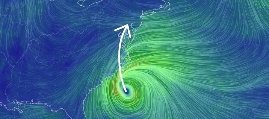
The NOAA National Hurricane Center has just named the system of interest Tropical Storm Ophelia. Ophelia will make landfall in coastal Carolina Saturday morning and quickly dissipate to just a depression/remnant low as it tracks northwards through NC, E VA through Saturday. It will then try to track into EPA/NJ but by that time (Sunday) it will be very weak with likely a loss of organized circulation. With that said, NJ will just deal with a low producing a rain and wind event that we’ve seen before.
I think this system is going to be more of an up-front hit between the hours of midnight tonight and about noon tomorrow (Saturday), maybe early afternoon tomorrow. This ~12-14 hour period should deliver the heaviest rates of rainfall, the highest onshore winds, and highest tidal cycle of concern for coastal flooding interests. This part of the system will affect the ocean-facing coasts of ECNJ/SENJ and immediate coastal areas the most re: coastal flooding and winds. The high tide of concern occurs just after noon on Saturday. Therefore, moderate coastal flooding is expected Saturday afternoon with a small outside chance of major. All other high tides from now through Monday, maybe Tuesday will be higher than normal but should stay in the minor, maybe moderate stages. The other kind of flooding (flash flooding) is also possible during this initial midnight tonight to Saturday afternoon front-end thump of rain and wind. Actual locations are impossible to determine but will likely occur under the best frontogenic banding. Wind gusts during this initial phase will likely peak somewhere in the 40-50mph range along the coasts with lesser values inland/away from the ocean. Thinking 20-30mph sustained winds along coast with less inland.
At some point between noon and late-afternoon Saturday, I expect a lull in at least the steadier rainfall. It will probably still be cloudy (maybe a few sunny breaks allowed by convective mechanisms). Those who see the sun for a short time will rush to comment “I could have had my outdoor event.” But for the most part, it should still be raw (periods of misting/light rain) and windy with tidal concerns still in play. This lull period should last into Saturday night. This should allow for any flash flooding areas to drain some and for low tide to relieve coastal areas later Saturday evening.
The rest of the system should then resume sometime between Saturday night and Sunday morning, and it honestly looks weak. I’m seeing just periods of scattered showers with manageable winds and tidal cycles. Conditions Sunday-Monday appear mostly nuisance without any serious safety hazards. Could it impact outdoor plans and activities? Sure, it’s going to be raw and pissy. But I don’t see any damaging wind potential or flooding concerns. It’s basically just tonight through tomorrow afternoon that the system should crank its hardest.
Once the low delivers its front-end impacts tonight through tomorrow afternoon, it will gradually weaken throughout the rest of the weekend as it drifts eastward towards and ultimately out over the ocean. The upper-level dynamics that once powered this cyclone offshore of the SE US will fizzle into nothing once it clashes with the ridge to its N/NE. It just won’t fizzle fast enough to give us a great second half of the weekend.
In English: Expect clouds to fill in and winds to continue picking up through this afternoon/evening (Friday), especially along the ECNJ/SENJ coastal areas. The rainstorm should move in around ~midnight tonight (give or take a few hours) and spread into all of NJ by early Saturday AM hours. The storm should then crank its hardest (heaviest rain, highest winds, highest tides) until sometime Saturday afternoon. A lull is then expected from Saturday afternoon into evening. Still raw, windy, and pissy at times but a major down step from how tonight/tomorrow morning is going to be. Periods of rain should then move back in for Sunday morning though Monday but as scattered showers meaning breaks (some decent) between the rain. It should all eventually fizzle out by Monday night/Tuesday morning. Total rainfall should vary from a quarter inch in NWNJ up to a few inches in SENJ for the entire system but most of that should fall between midnight tonight and Saturday afternoon. Winds should be their highest (gusts to 50mph) along the ECNJ/SENJ coast (less felt inland) between Saturday morning and Saturday evening. Wind-related power outages are very possible during this time. Flash flooding is possible inland and moderate, maybe major, coastal flooding is very likely along ECNJ/SENJ, especially during the early Saturday afternoon high tide. All other tidal cycles from now until Monday appear minor, maybe moderate re: coastal flooding. Basically, it cranks late-tonight through Saturday afternoon, takes a rain break Saturday afternoon-evening (wind still cranks with raw conditions), then returns to about a fourth of what it was tonight/tomorrow (nuisance not bad) from Sunday morning into Monday. By Tuesday the system should fizzle out. For surfing interests, this system will likely produce large unsurfable chop for at least Saturday-Sunday morning. Maybe some better definition swells form Sunday into Monday. This represents my best expectation going in and all updates from now-forward will be live observations posted on social media (Facebook, Twitter, Instagram, and Threads). Next week looks like a period of onshore flow without rain. Let’s get this system out of the way first. Have a great rest of your Friday and please be safe! JC
Premium Services
KABOOM Club offers inside info forecast discussion, your questions answered, and early storm impact maps (ahead of the public). At 99 cents per month, it’s an extremely feasible way to show support.
My Pocket Meteorologist (MPM), in partnership with EPAWA Weather Consulting, offers professional/commercial interests, whose businesses depend on outdoor weather conditions (snow plowing, landscaping, construction, etc.), with hyper-local text message alerts/forecasts and access to the MPM premium forum—the most comprehensive and technical forecast discussion available for PA and NJ.
Jonathan Carr (JC) is the founder and sole operator of Weather NJ, New Jersey’s largest independent weather reporting agency. Since 2010, Jonathan has provided weather safety discussion and forecasting services for New Jersey and surrounding areas through the web and social media. Originally branded as Severe NJ Weather (before 2014), Weather NJ is proud to bring you accurate and responsible forecast discussion ahead of high-stakes weather scenarios that impact this great garden state of ours. All Weather. All New Jersey.™ Be safe! JC


LOCAL FORECAST | INTERACTIVE RADAR | LATEST NJ WEATHER ALERTS | WEDDING FORECAST| PRIVACY POLICY
© Copyright 2026 Weather NJ LLC. All Rights Reserved.
Some information that can be found on our website is provided by a private weather station and is not an officially recognized station for weather reporting. Though we always strive to achieve accurate reporting for our own use, it is important that you do NOT depend on the data provided here for any purpose.
