

Rainstorm Approaching. Tues-Wed Snow Gaining Support.

Discussion: I know everyone is far-sighted on the Tuesday-Wednesday potential snowstorm. I will get to it but first, a few things between now and then.
We are still on track for a rain and wind system tonight (Friday) into early tomorrow morning (Saturday). Rain should push into WNJ/SWNJ between about 7-10pm tonight, fall steadily overnight, and end by 7am Saturday, possibly earlier. Models are averaging about an inch of total rainfall, give or take a quarter-inch. Winds should begin picking up some any minute now. Expect gusts to build from about 20mph to 30mph from late-this afternoon to about midnight. Winds should crank their hardest from about midnight tonight to 4am tomorrow morning. This should be about 35-50mph away from the ocean and 45-60mph along the ocean. Expect some pockets of lesser winds just like Tuesday night however it shouldn’t be as bad as Tuesday night. Coastal flooding a minor issue with tonight. Low tide occurs during peak onshore winds and it’s a quick mover. Minor coastal flooding at best. Freshwater rainfall could end up being the biggest flooding threat as water tables are still high. Target areas for this would be where Delaware River opens up to Delaware Bay and Raritan Bay. Once it all clears out Saturday morning, strong NW and/or W/NW winds will ensue.
Saturday will be a day of transition. Your high temperatures will likely be met just after midnight/before 3am when the warm sector is raging the hardest ahead of the cold front. Once the cold front is through, you should expect a decline in temperatures throughout the rest of the day and especially after sundown. Any leftover water, especially away from coastal areas, are subject to freezing Saturday night. This includes wet swampy grounds, freestanding puddles, or any wet surfaces. We’ll have the colder NW or W/NW winds to help evaporation but that will battle the very wet ground situation. Even though it will get much colder than it has been on Saturday, it will still only be stale Canadian cold airmass…cold enough for much of NJ to dip below freezing overnight but not yet the real cold that should arrive with the Sunday Arctic front.
Sunday is starting to look interesting regarding some conversational snow that could occur. Some very cold energy will be moving through NJ in the form of an Arctic front. In similar principle of a summertime frontal thunderstorm, the “much colder air” (Arctic front) will be wedging under the “just cold air” and could spark convective precipitation in the form of snow flurries, showers, or even squalls which are subject to lake effect enhancement. It’s a low probability but worth mentioning. Flizzard type stuff where visibility is the more dangerous safety hazard, not the trace-to-light accumulations that result from such in a very short amount of time. I’ll be looking for this on radar Sunday should it come into fruition. Real powdery fluffy stuff which leads us into the storm system of higher interest, Tuesday-Wednesday.
Monday will be cold and clear and that should hold right into Tuesday when precipitation will likely approach NJ from the W/SW as snow. We are still 4 days (96 hours) away from this potential snowstorm. The shorter-range models are not even within range yet so we’re still looking at the longer-range bigs like the GFS, Euro, Canadian, UK Met, etc. and especially their ensemble members to compare to operational runs. The data today is conclusive in that there will be a storm. However the exact location of the heaviest snow is still far from ironed-out. Operational runs are spread and most inconclusive. The Canadian hammers NE of 95 only. The GFS is more of a statewide snow. The Euro is starting to target SNJ/SENJ. So…all over the place. The ensembles, however, are in good agreement for at least a significant snowfall across most of New Jersey. Here are the ensemble means from the GFS, Euro, and Canadian. A few things to keep in mind…ensemble means are very conservative (they show 6 inches but 12 actually falls). Also this is at 10:1 ratios. Actual ratios, because of the Arctic air mass, will be closer to 15:1 maybe higher along and NW of 95:
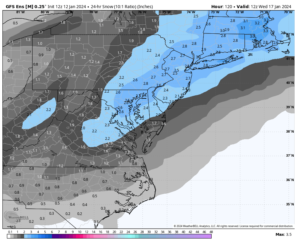
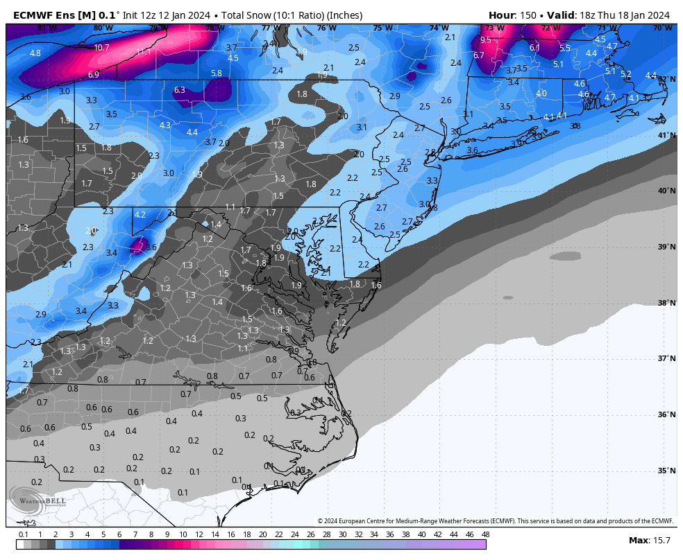
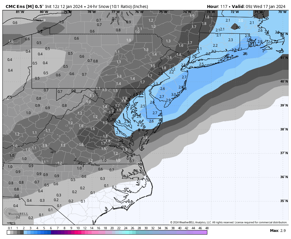
The northern stream energy is still over the Pacific Ocean. Until that is sampled better over land (Saturday night), models will continue to flop around the jackpot zone in the Mid-Atlantic US. So tonight’s 00Z runs and tomorrow’s 12Z runs will likely maintain the status quo. Tomorrow night’s runs, however, will be considered huge for what could happen Tuesday-Wednesday. There’s also another snowy signal gaining support around January 19-20 (Friday-Saturday) which could conclude the colder Arctic airmass period and lead us into a January thaw. At least one or two cold reloads would then be likely for February but let’s not get ahead of ourselves.
In English: Rain and wind move in between 7-10pm tonight (Friday). Sort of like how Tuesday night was but about half-to-3/4 as bad regarding rain, wind, and flooding interests. Worst winds along the coast. Rain ends Saturday morning, but W/NW winds should remain as colder air moves in and puts NJ in an active winter pattern through about ~Jan 22. Saturday looks colder but is day of transition-not as cold as Sunday which should feature an Arctic frontal passage with possible snow flurries, showers, and squalls. Solid cold Sunday night, through all of Monday, and into Tuesday as precipitation approaches in the form of a potential snowstorm for New Jersey. At this point I believe there will be snow for New Jersey in the Tuesday-Wednesday period. It’s just too early to put out any specifics on jackpot zone as models are still flipping and flopping around. Until Saturday night, it will likely stay this way. Careful not to get too emotionally juked one way or another with each model run. The overall picture says at least some form of snow will happen. Also watching another snowstorm signal for January 19-20 (next Friday-Saturday). Have a great rest of your Friday and please be safe! JC
Premium Services
KABOOM Club offers inside info forecast discussion, your questions answered, and early storm impact maps (ahead of the public). At a buck per month, it’s an extremely feasible way to show support.
My Pocket Meteorologist (MPM), in partnership with EPAWA Weather Consulting, offers professional/commercial interests, whose businesses depend on outdoor weather conditions (snow plowing, landscaping, construction, etc.), with hyper-local text message alerts/forecasts and access to the MPM premium forum—the most comprehensive and technical forecast discussion available for PA and NJ.
Get your KABOOM Inside Out pajamas and more at the KABOOM shop!
Jonathan Carr (JC) is the founder and sole operator of Weather NJ, New Jersey’s largest independent weather reporting agency. Since 2010, Jonathan has provided weather safety discussion and forecasting services for New Jersey and surrounding areas through the web and social media. Originally branded as Severe NJ Weather (before 2014), Weather NJ is proud to bring you accurate and responsible forecast discussion ahead of high-stakes weather scenarios that impact this great garden state of ours. All Weather. All New Jersey.™ Be safe! JC


LOCAL FORECAST | INTERACTIVE RADAR | LATEST NJ WEATHER ALERTS | WEDDING FORECAST| PRIVACY POLICY
© Copyright 2026 Weather NJ LLC. All Rights Reserved.
Some information that can be found on our website is provided by a private weather station and is not an officially recognized station for weather reporting. Though we always strive to achieve accurate reporting for our own use, it is important that you do NOT depend on the data provided here for any purpose.
