

Rainstorm Approaching
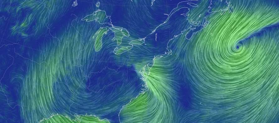
Discussion: The surface low is currently over the ~W Kentucky area and should continue to track NE up the Appalachian Mountain chain between now and Sunday morning.
Conditions should deteriorate soon, especially for SNJ, as the leading edge of precipitation pushes into NJ from the S/SW. You can see it approaching on radar now. This precipitation should be the heaviest of the entire system but will not be of long duration. Expect the precipitation to continue advancing N/NE into the rest of NJ between now and late-afternoon/early-evening. Expect the heaviest precipitation to also scale back from S/SW to N/NE as we get closer to midnight. After that, more rain is still possible overnight tonight and through Saturday (especially E NJ), it just won’t be as heavy or as concentrated as what’s about to move through today/tonight. We’re still looking at a few inches of rainfall which is not good for the Delaware River areas of coastal flooding interest.
Although the primary precipitation band is moving S/SW to N/NE, the winds will be off the ocean, perpendicular to the advancement of the precipitation. Therefore, we’re looking at strong E/SE winds for today’s main batch of rain. On Saturday, we should see more of a northerly wind as the coastal low possibly scrapes parts of ENJ. By Saturday night/early Sunday am, the precipitation should clear to the N/NE of NJ as winds subside for a chillier Halloween Sunday.
Coastal flooding is a concern, not only for ocean-facing coasts, but also those around the Delaware Bay and River. The E/SE onshore flow today will align with pushing water into the Delaware Bay and also with the inlets of the SENJ coast. Ocean coasts are looking at minor-to-moderate coastal flooding. Delaware Bay coasts are looking at moderate to possibly major coastal flooding. Remember, we’ll have a few inches of rain falling/draining into wind-driven Delaware Bay/inlet surge. With the Delaware River already up from the rain earlier this week, there could be serious flooding issues. Remember not to drive through a water filled street. Avoid the hazard!
With synoptics of this nature, toss normal temperature expectations out the window (ex: warmest in the afternoon/coldest at night). We’re actually going to warm into this evening with the onshore flow. The ocean is still 65F so much of NJ will align to that general range as such temps are brought onshore. NWNJ elevations might be the only part of NJ that doesn’t warm into the 60s overnight tonight. Once winds become northerly (Saturday PM), NJ will be allowed to fall back into the 50s again. Then Sunday looks like a day in the 50s for trick or treating activities. After that we gradually become cooler Monday and Tuesday followed by a solid cold shot Wednesday that lasts into next weekend. The Wednesday cold shot might be our first early-taste or reminder that… winter is coming.
In English: Expect rain to move into NJ between now and later today. Expect rain to taper some by midnight-ish tonight. During this rain period, expect increased winds, especially along the shore, and coastal flooding along both ocean and Delaware Bay/River coasts. Saturday should then remain wet and gloomy with more rain for E NJ than W NJ. We should dry out for Sunday and remain cooler until a SOLID cold shot moves in next ~Wednesday. Be safe! JC
Download the free Weather NJ mobile app on Apple or Android. It’s the easiest way to never miss Weather NJ content. Our premium services go even further above and beyond at the hyper-local level.
Jonathan Carr (JC) is the founder and sole operator of Weather NJ, New Jersey’s largest independent weather reporting agency. Since 2010, Jonathan has provided weather safety discussion and forecasting services for New Jersey and surrounding areas through the web and social media. Originally branded as Severe NJ Weather (before 2014), Weather NJ is proud to bring you accurate and responsible forecast discussion ahead of high-stakes weather scenarios that impact this great garden state of ours. All Weather. All New Jersey.™ Be safe! JC


LOCAL FORECAST | INTERACTIVE RADAR | LATEST NJ WEATHER ALERTS | WEDDING FORECAST| PRIVACY POLICY
© Copyright 2026 Weather NJ LLC. All Rights Reserved.
Some information that can be found on our website is provided by a private weather station and is not an officially recognized station for weather reporting. Though we always strive to achieve accurate reporting for our own use, it is important that you do NOT depend on the data provided here for any purpose.
