

Rainstorm Developing for Sunday-Monday
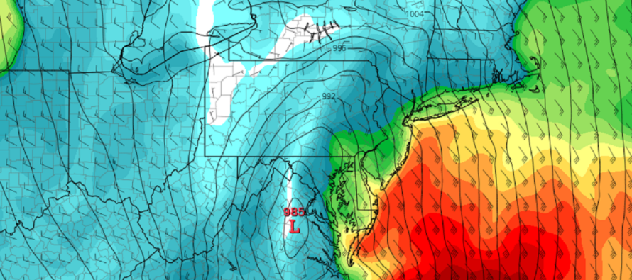
Discussion: We’re dry and milder through Saturday. A rainstorm is currently developing and will deliver impacts to New Jersey from Sunday afternoon through Monday morning. The low is currently developing in the Gulf of Mexico and will ride up the entire east coast (just W of the coast) between now and Monday morning. It looks to deepen to at least sub-990mb, possibly sub-980mb. That should produce region-wide moderate/high winds around the storm center as it tracks northward. Let’s break the impacts down:
Rainfall could begin as early as late-Sunday morning but could hold off until later in the afternoon. First drops will be lighter. A steady rain might not develop until closer to Sunday evening. Rainfall should then intensify between late Sunday night and sunrise Monday morning, tapering off by late Monday morning/afternoon. A general range of 1-3 inches of total rainfall can be expected across all of NJ, depending on where the heaviest precipitation bands occur. There’s a good chance of flash flooding problems especially areas near creeks and streams prone to traditional rain flooding.
Winds should be the worst from late Sunday night through about sunrise Monday morning. They should start picking up through Sunday afternoon and build stronger through overnight. We can expect the first half of the system’s winds (Sunday PM) to be strong off the ocean (progressing from E/SE to SE to S/SE). These winds are typically felt much stronger along the coast (40-60mph) while many areas away from the ocean ask “what strong winds?” We should then expect a brief lull when the low passes nearby New Jersey around midnight or just after. Winds should then sharply resume for all of NJ for the rest of Monday morning mostly out of the NW or W/NW (behind the low).
Coastal Flooding should be held in the minor category. Astronomical tides are lower and this is a quick moving storm system. With that said, there will still be two high tides of coastal flooding interest. The first is just before noon on Sunday. The second is just before midnight Sunday night. During these tides we’ll have storm wind-driven surge off the ocean but again, with lower astronomical tides (no full or new moon). Therefore the most likely scenario is minor coastal flooding which aligns with current tidal guidance.
It all clears out by Monday but we should be left with some colder NW or W/NW winds for the rest of the day. We can then address the next storm signals showing up as well as the expected colder pattern change to end December/start January.
In English: Tonight looks cooler, not colder like prior few nights. Saturday looks mild and dry. A great day to get things done outside. Clouds should increase Sunday morning with periods of moderate-to-heavy rain moving in by Sunday afternoon and lasting until Monday morning. Winds could gust 40-60mph along the coast (lesser away from the ocean) Sunday night into Monday morning. ECNJ/SENJ could see minor coastal flooding and beach erosion. A nasty Sunday PM-Monday AM. Be safe! JC
Premium Services
KABOOM Club offers inside info forecast discussion, your questions answered, and early storm impact maps (ahead of the public). At a buck per month, it’s an extremely feasible way to show support.
My Pocket Meteorologist (MPM), in partnership with EPAWA Weather Consulting, offers professional/commercial interests, whose businesses depend on outdoor weather conditions (snow plowing, landscaping, construction, etc.), with hyper-local text message alerts/forecasts and access to the MPM premium forum—the most comprehensive and technical forecast discussion available for PA and NJ.
Get your KABOOM Inside Out pajamas and more at the KABOOM shop!
Jonathan Carr (JC) is the founder and sole operator of Weather NJ, New Jersey’s largest independent weather reporting agency. Since 2010, Jonathan has provided weather safety discussion and forecasting services for New Jersey and surrounding areas through the web and social media. Originally branded as Severe NJ Weather (before 2014), Weather NJ is proud to bring you accurate and responsible forecast discussion ahead of high-stakes weather scenarios that impact this great garden state of ours. All Weather. All New Jersey.™ Be safe! JC


LOCAL FORECAST | INTERACTIVE RADAR | LATEST NJ WEATHER ALERTS | WEDDING FORECAST| PRIVACY POLICY
© Copyright 2026 Weather NJ LLC. All Rights Reserved.
Some information that can be found on our website is provided by a private weather station and is not an officially recognized station for weather reporting. Though we always strive to achieve accurate reporting for our own use, it is important that you do NOT depend on the data provided here for any purpose.
