

Regarding Henri
Discussion: We have two things to talk about, Fred’s remnants and Henri’s track. Fred’s remnants are currently moving from West Virginia into SW PA. They should continue tracking NW across CPA today and then into New England Thursday into Friday. New Jersey impacts should be far less than PA. For today and most of this evening, we’re dealing with just a soupy and muggy air mass with S flow. There might be some isolated pop-ups in the flow but nothing organized until later tonight. Between late tonight and Thursday morning, a frontal boundary (now attached to Fred’s mid-latitude cyclone) is expected to push through. Rain-wise it looks very unimpressive…maybe a short period of downpour along a very thin linear segment of frontal precipitation. I’m more concerned with the wind shear environment producing localized instances of tornadoes surrounding this frontal passage. NWNJ and W NJ would have the best chance at this. SENJ would have a much lower chance of this. The best tornado dynamics will exist over Maryland and PA tonight. I’m sure you will hear about it on social media tomorrow morning. But there’s a non-zero chance of a tornado spin-up statewide in New Jersey overnight tonight. Highest hours of impact should be between 11pm tonight (Friday) and 4am tomorrow (Thursday) morning. I’ll be tracking in real-time. Hopefully it’s just a mostly dry frontal passage with minimal trouble (most probable outcome). But we all know what funky remnant tropical cyclone energy can do in NJ, don’t we.
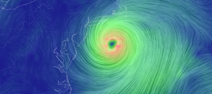
Regarding Henri, now a tropical storm, we’re now beyond the time window of confidence for what Henri want’s to do. If you remember in my prior report, I discussed how he would kind of swirl in place near Bermuda for a bit before establishing it’s track in response to ridge weakness and upper-level steering flow. Well it looks like there will be a ridge in SE Canada this Saturday/Sunday. That will make Henri want to round out from Bermuda and track up the US east coast (near NJ) and follow the ridge weakness. This by itself would mean a pretty close pass of Henri to the Jersey shore. Our saving Grace (who btw is crossing the Yucatan Peninsula and heading towards Mexico – no threat to NJ) is that an upper level low wants to develop over W PA. If this upper-level low develops then the upper-level steering currents from the SE side of the ULL will help the sliding ridge turn Henri away from NJ, keeping it offshore. If the ULL develops weaker or is late then NJ could be looking at a closer pass from Henri. Nothing is suggesting a landfall currently but some of the hurricane models take a closer pass to NJ than others. So a lot is riding on the ULL that NEEDS to develop in W PA to keep Henri out to sea. Either way, it would be this Saturday into Sunday when Henri would either be just nearing the Jersey shore or passing farther out to sea. I’ll need to watch more evolution of observations and model guidance before making the call. Regardless, expect dangerous rip currents and elevated swell. A surfer’s paradise. A bad swimmer’s nightmare. Right now models are split. The Euro has a weaker widespread rain for NJ late Saturday night. The GFS has a more organized storm close to the NJ shore on Sunday morning/afternoon. Let’s see where things are tomorrow. Either way, start to have a plan B in mind if you’re along the Jersey shore this Saturday-Sunday. There’s a small chance things take a turn for the worse.
In English: The rest of today should be muggy, mixed with more clouds than sun, with a small chance of isolated showers or thunderstorms. Stronger thunderstorms and heavier rain are possible late tonight into early tomorrow morning. There is a chance of a few tornadoes overnight tonight. Mostly likely, tornadic activity will be to our W in Maryland and PA. But some of that energy could spill into NJ tonight. With that said, NWNJ and WNJ are the most favored for rain and tornado chances. SENJ the least favored. I’ll be tracking live tonight. Watching Henri very closely to see how close it will come to NJ this Saturday-Sunday. Will report accordingly. Be safe! JC
Download the free Weather NJ mobile app on Apple or Android. It’s the easiest way to never miss Weather NJ content. Our premium services go even further above and beyond at the hyper-local level.
Jonathan Carr (JC) is the founder and sole operator of Weather NJ, New Jersey’s largest independent weather reporting agency. Since 2010, Jonathan has provided weather safety discussion and forecasting services for New Jersey and surrounding areas through the web and social media. Originally branded as Severe NJ Weather (before 2014), Weather NJ is proud to bring you accurate and responsible forecast discussion ahead of high-stakes weather scenarios that impact this great garden state of ours. All Weather. All New Jersey.™ Be safe! JC


LOCAL FORECAST | INTERACTIVE RADAR | LATEST NJ WEATHER ALERTS | WEDDING FORECAST| PRIVACY POLICY
© Copyright 2026 Weather NJ LLC. All Rights Reserved.
Some information that can be found on our website is provided by a private weather station and is not an officially recognized station for weather reporting. Though we always strive to achieve accurate reporting for our own use, it is important that you do NOT depend on the data provided here for any purpose.
