

Rough Start. Beautiful Finish (Aug 28-30)
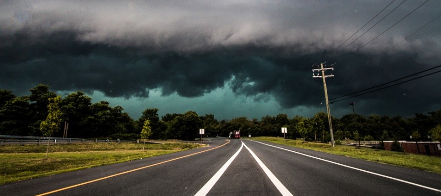
Discussion: The upper-jet looks very flat and zonal this weekend. Upper-level geopotential heights look average to slightly-below average. While boring aloft, the lower-levels/surface conditions should respond as follows. Today we have the leading edge of unsettledness beginning by late-afternoon/early-evening. This should come in the form of a mesoscale convective system along the approaching warm front. Therefore, it is very possible to see bowing segments along a storm front that approaches from the W/NW and scales through NJ (from W/NW to E/SE) between about 4-8pm (general window). This storm front could feature gusty winds and seems to like SNJ better than NNJ. CNJ could fall on the edge of it. We then deal with a broad swath of unsettled conditions, Friday night through Saturday, from the remnants of Laura. Saturday does not look like an all day continuous washout for all of NJ but rather on-and-off periods of downpours/thunderstorms. You might see a few breaks here and there between but a very unsettled day. After that a cold front will push through and deliver majestic weather for Sunday into Monday.
Note: Unless specifically mentioned by location (Example: NNJ elevations, SENJ immediate coast, Interior CNJ/SNJ, etc.) assume the following forecast language is statewide for New Jersey. When I say “from elevations to sea” I mean from NWNJ mountains spreading down to SENJ coastal areas. Directions are shortened (N = North, S = South, W/SW = West/SouthWest, etc.).
Friday (Aug 28) high temperatures should reach the mid-to-upper 80s. Skies should be partly cloudy with a humid feel. Showers and thunderstorms are likely, some possibly severe, later this afternoon into early evening hours. Winds should be light out of the W (when not under a thunderstorm). Overnight lows should fall to the lower-70s.
Saturday (Aug 29) high temperatures should reach near-80 with a humid feel. Skies should be very unsettled with periods of rain and thunderstorms possible. It doesn’t look like a continuous washout for all of NJ all day. It seems more like on-and-off downpours with possibly some breaks between. Winds should be light out of the S/SW. Overnight lows should range from mid-50s to mid-60s from elevations to sea.
Sunday (Aug 30) high temperatures should struggle to escape the 70s with a much drier feel. Perhaps it reaches 80 in some spots but will still feel amazing with lower humidity. Skies should be mostly sunny. Winds should be light out of the NW. Highs should fall into the 50s for most of NJ. Immediate coastal regions however (along Atlantic Ocean and Delaware Bay) could hang in the 60s from marine influence.
An early look at next week indicates average late-summer conditions for NJ. The really nice and dry conditions should spill over into Monday. Tuesday looks a little rainier/stormier than the rest of the days but overall a good week. Let’s revisit on Sunday. Everyone have a great weekend and please be safe! JC
Download the free Weather NJ mobile app on Apple and/or Android. It’s the easiest way to never miss Weather NJ content. Our premium services go even further above and beyond at the hyper-local level. Looking for industrial-caliber long-range forecasting data that I personally use and recommend? Check out WeatherTrends360!
Jonathan Carr (JC) is the founder and sole operator of Weather NJ, New Jersey’s largest independent weather reporting agency. Since 2010, Jonathan has provided weather safety discussion and forecasting services for New Jersey and surrounding areas through the web and social media. Originally branded as Severe NJ Weather (before 2014), Weather NJ is proud to bring you accurate and responsible forecast discussion ahead of high-stakes weather scenarios that impact this great garden state of ours. All Weather. All New Jersey.™ Be safe! JC


LOCAL FORECAST | INTERACTIVE RADAR | LATEST NJ WEATHER ALERTS | WEDDING FORECAST| PRIVACY POLICY
© Copyright 2026 Weather NJ LLC. All Rights Reserved.
Some information that can be found on our website is provided by a private weather station and is not an officially recognized station for weather reporting. Though we always strive to achieve accurate reporting for our own use, it is important that you do NOT depend on the data provided here for any purpose.

)