


Saturday Could Sting in New Jersey

Discussion: I want to touch on yesterday (Thursday) before looking at tomorrow. As someone who spent almost 40 years of my life growing up in the Manahawkin area, I can only remember a few times where that much water fell out of the sky in only a few hours of thunderstorm training. One of them is September of 2006 which dropped 10 inches+ in 3 hours and flooded out my house completely. Anyway, yesterday featured a frontal boundary that was sinking from N to S through NJ. There was also a meso low riding the frontal boundary. The storm cell of interest initially developed along the frontal boundary over the Norristown/Bensalem area of E PA and tracked towards Browns Mills area of NJ as a weak cell. The meso low then came through and sparked an area of lifting in the Tabernacle/Chatsworth area. This enhanced the weak cell into a severe thunderstorm complex which floated E/SE until it came to rest over the Pemberton/Barnegat/Manahawkin/LBI area. While the meso low provided enough lifting to keep the storm complex alive, the storms outflow boundary started pushing back to the W/NW where the storm originated (Tabernacle/Chatsworth). This W/NW outflow was pushing into headwinds (the general NW flow behind the sinking frontal boundary. So the storm complex and it’s E/SE outflow basically formed an immovable ramp (mesofront) for the flow to ramp upwards and support a stationary thunderstorm for about 2.5 hours. Additionally, the storm was well vented aloft in our Ring of Fire/Death Ridge US pattern which 1) produced a highway of steering current winds from the Great Lakes towards NJ and 2) acted as the same for Canadian wildfire smoke. For a small time there, the storm acted as a fixed boulder in a river of flow. Because of the ring of fire and local hot/humid/energy dynamics, the storm was allowed to reach well into severe criteria as 80mph winds gusts and 1.25 inch hail were achieved. The storm then finally exhausted its outflow and continued E/SE with the sinking boundary around 8pm.
Today (Friday) we have a break in rain and storm activity. The boundary is well to the S of NJ across North Carolina and NJ dew point temperatures are ranging from 48-65 NNJ to SNJ (a much less humid feel). It’s a nice-feeling day with afternoon highs maxing out in the mid-80s for most areas. About the only complaint for Friday is the smoke lingering around/Air Quality Index (AQI). This is taking its time for the most concentrated strip of smoke to push to the S of NJ. We at least know that it has to be gone by Saturday evening as a series of stormfronts and frontal boundaries push through NJ from NW to SE. But from now until then, the smoke will likely linger over much of NJ. We’ll discuss more in the next section.
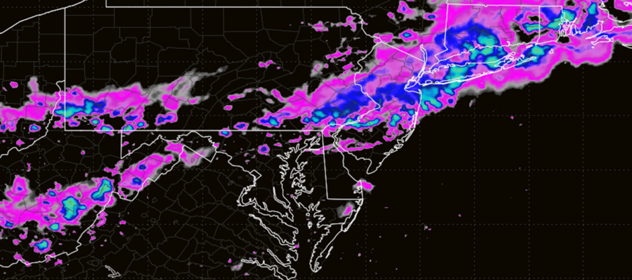
Now let’s demystify tomorrow (Saturday). We know we have a solid environment capable of producing damaging thunderstorms (bottom of swinging trough, diurnal destabilization, adequate wind shear, adequate lifting trigger (frontal boundary), and adequate moisture to lift up into storm creation land. So yes, all the ingredients are on the table for more newsworthy damage out of NJ by Saturday night/early Sunday morning. However, we don’t know how much the smoke layer will impact storm formation. We don’t know how much energy will be zapped across NNJ/CNJ with initial Saturday morning showers and storm activity. These unknowns therefore lead me to a range of solutions based on probability. Will it rain for most of NJ at least a few times Saturday? Yes, I am confident in that. Will it be an all-day washout? No. I am seeing most of SNJ staying dry until after noon and possibly until late-afternoon/early evening. I am seeing rounds of linear stormfronts wanting to come through from NW to SE which typically means shorter durations of downpours and storms with lulls between. This is far from a “everyone gets severe weather” scenario. It’s much more of an “everyone will see rain and moderate breeze but only some could experience the worst of it.”
With that said, I am seeing an initial round of showers and thunderstorms moving through NNJ, maybe some of CNJ, earlier in the day Saturday. Then I am seeing possibly a series (1-3 different stormfronts) push through NJ from NW to SE between afternoon and early Sunday AM. I think everyone gets in on at least a downpour or two with a lot of embedded frequent lightning. I think some more localized activity could include damaging straight-line winds, more hail, possible tornadoes and a few more inches of rainfall. Eventually a front will clear it all out by early Sunday making for a gorgeous Sunday day into Sunday evening. That spills over into Monday and then we’re back to more rain/storm potential for mid-week.
In English: Today (Friday) is free from any flooding downpours or damaging thunderstorms however we are still dealing with the smoke. Tomorrow (Saturday) looks like a series of downpours and thunderstorms but not an all-day washout. Much of SNJ and CNJ could see no rain until later in the afternoon, possibly early evening. NNJ should see some rain earlier in the day but that could stunt storm activity for NNJ later in the day, leaving CNJ and SNJ to take the brunt of it for afternoon/evening hours. But for the linear stormfronts that do come through, expect at least rain and moderate breeze statewide. What could happen in more of a localized manner are flash-flooding downpours, hail in-excess of a 1-inch diameter, frequent lightning, and damaging winds in the form of straight-line winds and/or tornadoes. With that said, the wind potential is anything from moving loose outdoor stuff around to Dude, where’s my roof? One of those scenarios where it makes sense to secure small human beings. I’ll be providing radar observation posts and updates throughout the day tomorrow. Sunday then looks great as we’ll be behind a cold front passage that clears the smoke and storms out to sea with a more refreshing feel. Have a great rest of your Friday and please be safe! JC

Jonathan Carr (JC) is the founder and sole operator of Weather NJ, New Jersey’s largest independent weather reporting agency. Since 2010, Jonathan has provided weather safety discussion and forecasting services for New Jersey and surrounding areas through the web and social media. Originally branded as Severe NJ Weather (before 2014), Weather NJ is proud to bring you accurate and responsible forecast discussion ahead of high-stakes weather scenarios that impact this great garden state of ours. All Weather. All New Jersey.™ Be safe! JC



LOCAL FORECAST | INTERACTIVE RADAR | LATEST NJ WEATHER ALERTS | WEDDING FORECAST| PRIVACY POLICY
© Copyright 2026 Weather NJ LLC. All Rights Reserved.
Some information that can be found on our website is provided by a private weather station and is not an officially recognized station for weather reporting. Though we always strive to achieve accurate reporting for our own use, it is important that you do NOT depend on the data provided here for any purpose.

