

Saturday Morning Snow a GO in New Jersey
Discussion: There’s not a while lot to say about this Saturday morning. Some call this kind of system a weak sliding wave, a southern slider, or sometimes a “South Jersey Express.” Well, this is going to be more like a CNJ/SNJ express but with SNJ favored for the highest snow accumulations.
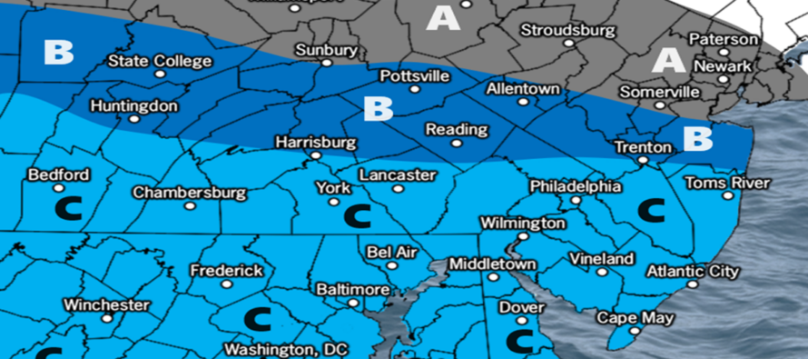
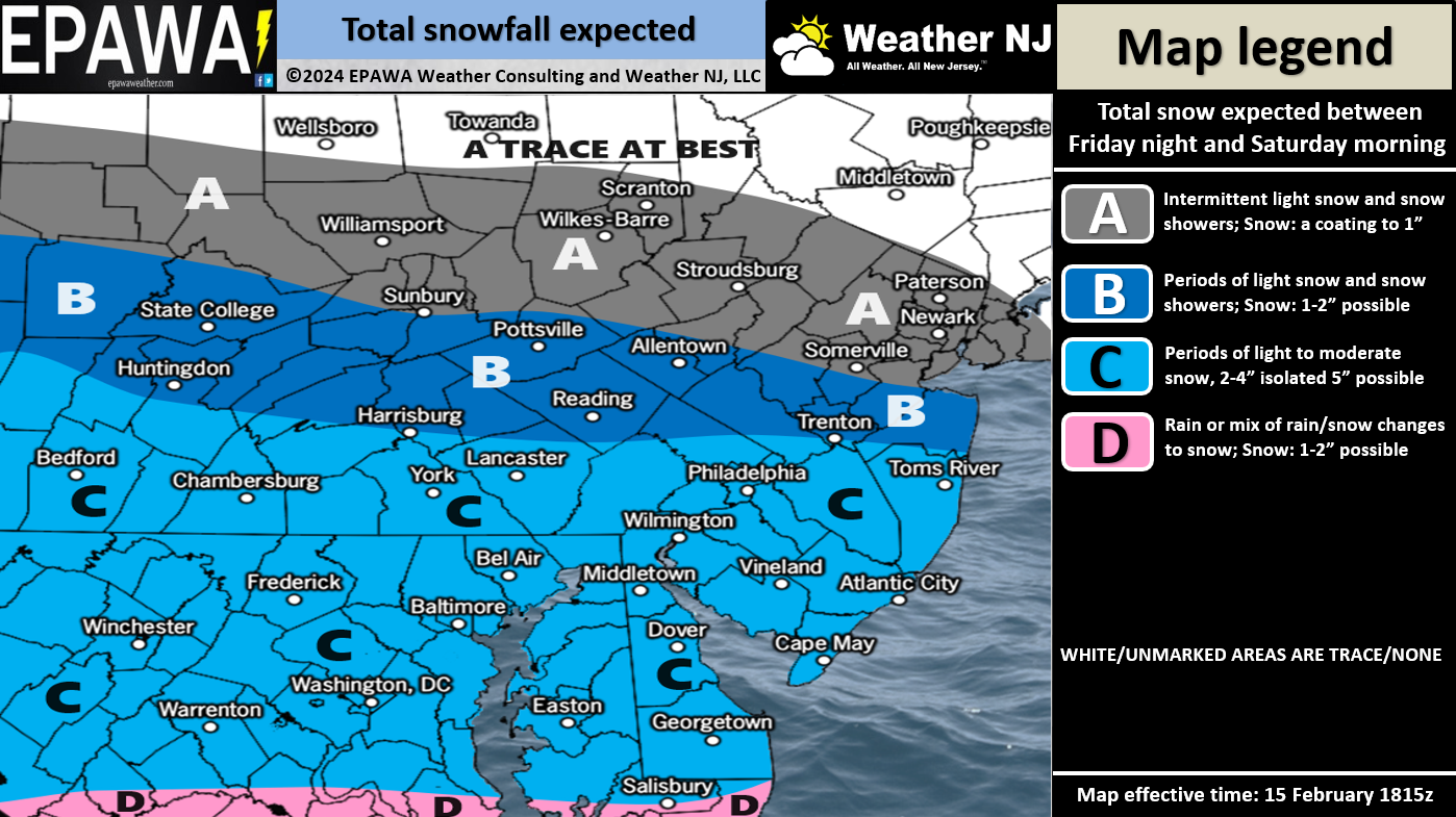
It’s a zonal-tracking (W-to-E) shortwave from the northern branch of energy only, no south branch involved. Blocking is not yet established over Greenland and the system moving through NY State/New England will leave a progressive railway for the Saturday wave to track through…a quick mover. There’s nothing to turn this N or S outside of some basic variation of maybe 10-20 miles N to S. But that still leads to our general idea represented in this snow map:
Timing – Temperatures should fall gracefully after sunset tomorrow evening (Friday evening) with most NJ locations dropping below-freezing prior to midnight. Snow will then approach from the W into mainly CNJ/SNJ anytime after midnight (early Saturday AM). Light-to-moderate snowfall is then possible, mainly across CNJ/SNJ but possibly for NNJ, from early Saturday AM hours until about 10am. That’s the grand window. Keep in mind that snow will move into WNJ first and clear ENJ last. So, for WNJ, it’s more of a 1am to 7am deal. For ENJ, more of a 3am to 9am deal. So, about a six-hour window of light-to-moderate snow. Once the snow clears out, temps will want to climb above freezing, especially for the coastal plain SE of I-95/NJTP. The snowpack should hold the surface slightly cooler, but I do expect some meltage once the sun is up high Saturday.
There are no coastal flooding or wind issues associated with this system, just a period of snowfall that will likely stick to all surfaces as fluffier more traditional snow, not the heavy wet stuff.
In English: Temperatures will drop Friday night and then light-to-moderate snow will fall across NJ Saturday morning between midnight and about 10am. The above snow map illustrates our expected amounts to fall and stick. As you will see, it is targeting SNJ for the highest amounts, CNJ with the second highest amounts, and NNJ with the least amount of snow accumulation. It all clears ENJ by noon Saturday and then temps warm above freezing to melt some of it. This is our first call. Tomorrow will be our final call and then live observations will begin late Friday night. Have a great rest of your Thursday and please be safe! JC
Premium Services
KABOOM Club offers inside info forecast discussion, your questions answered, and early storm impact maps (ahead of the public). At a buck per month, it’s an extremely feasible way to show support.
My Pocket Meteorologist (MPM), in partnership with EPAWA Weather Consulting, offers professional/commercial interests, whose businesses depend on outdoor weather conditions (snow plowing, landscaping, construction, etc.), with hyper-local text message alerts/forecasts and access to the MPM premium forum—the most comprehensive and technical forecast discussion available for PA and NJ.
Get your KABOOM Inside Out pajamas and more at the KABOOM shop!
Jonathan Carr (JC) is the founder and sole operator of Weather NJ, New Jersey’s largest independent weather reporting agency. Since 2010, Jonathan has provided weather safety discussion and forecasting services for New Jersey and surrounding areas through the web and social media. Originally branded as Severe NJ Weather (before 2014), Weather NJ is proud to bring you accurate and responsible forecast discussion ahead of high-stakes weather scenarios that impact this great garden state of ours. All Weather. All New Jersey.™ Be safe! JC


LOCAL FORECAST | INTERACTIVE RADAR | LATEST NJ WEATHER ALERTS | WEDDING FORECAST| PRIVACY POLICY
© Copyright 2026 Weather NJ LLC. All Rights Reserved.
Some information that can be found on our website is provided by a private weather station and is not an officially recognized station for weather reporting. Though we always strive to achieve accurate reporting for our own use, it is important that you do NOT depend on the data provided here for any purpose.
