

Saturday Morning Snow Developing
Discussion: Today (Wednesday) has a much colder feel to it especially with the winds. Most areas (less the immediate ECNJ/SENJ coasts) are struggling to break out of the 30s. Tonight we’ll dip into the 20s and ultimately bottom-out in the upper-teens/lower-20s for many by daybreak tomorrow (Thursday) morning. On Thursday, we’re back up to highs in the 35-40 range but then overnight temps actually maintain or spike a little higher into the 40s for extreme SNJ (NNJ and CNJ remain colder in 30s). A clipper low will be moving through NY State/New England at that time. To the south of that clipper low will be a warm sector ahead of a mostly dry cold front (showers possible). So, for NJ, a small synoptic temp spike overnight lasting through Friday afternoon high temps (35-45 NNJ to SNJ), followed by a temp plunge after sundown Friday evening. Overnight lows Friday night into Saturday morning should drop below-freezing statewide. Currently looks like 27-30 for most of NJ during Saturday AM hours with immediate SENJ coast closest to 32. This is cold enough for snow to fall and stick even in SNJ. Aloft will be very cold so no mixing issues expected, just snow.
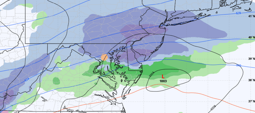
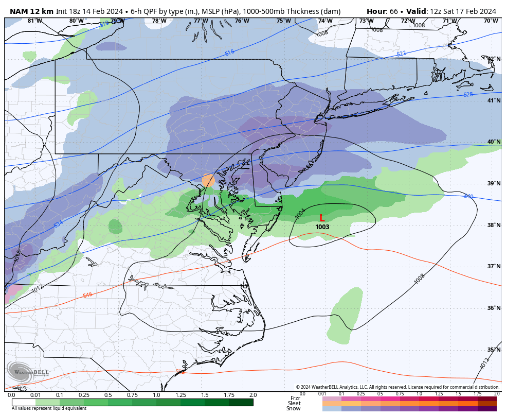
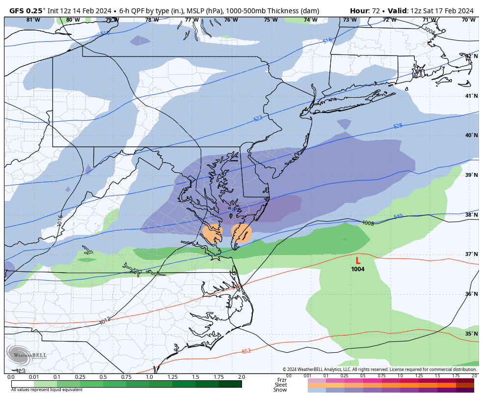
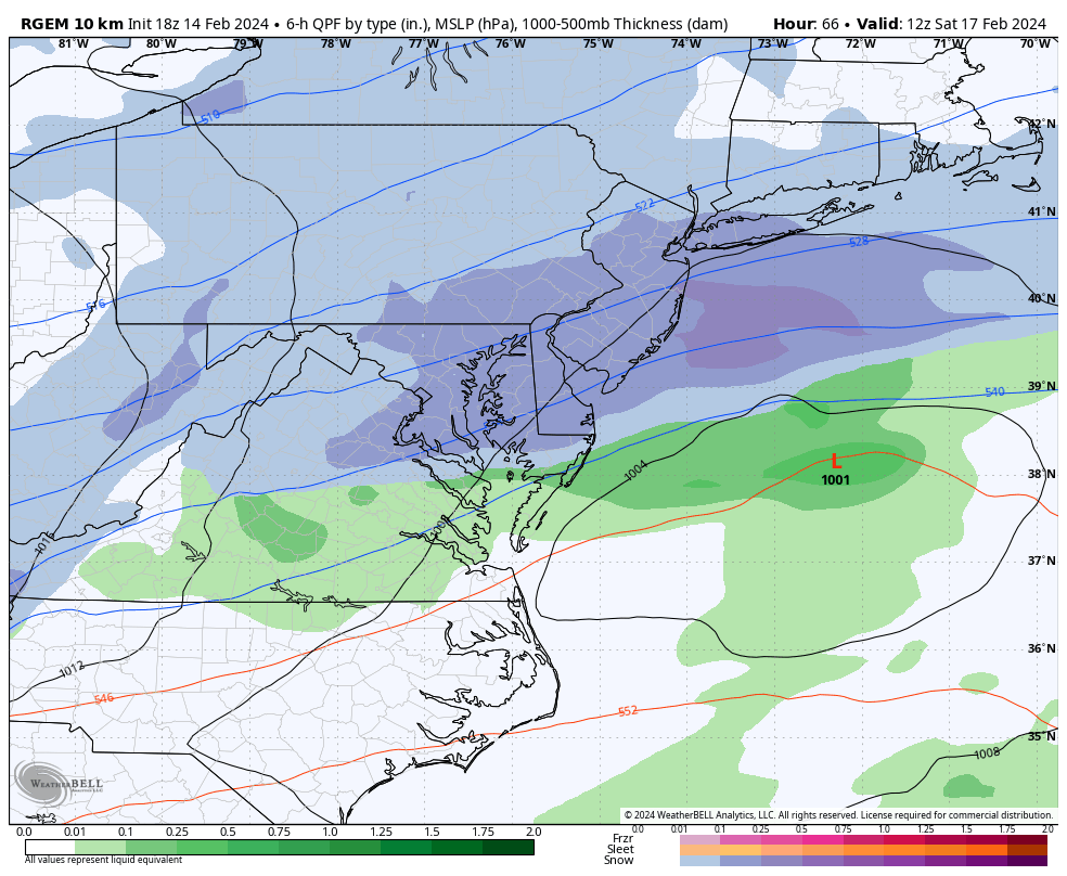
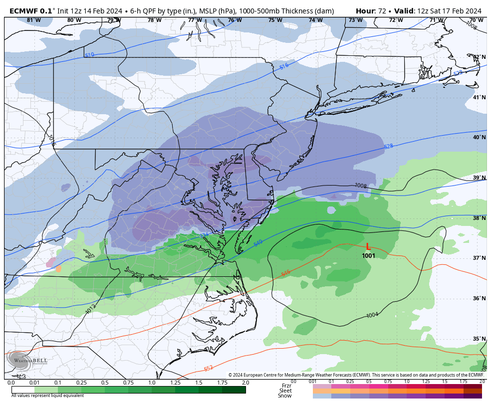
Saturday’s system involves a flat shortwave trailing in the colder wake of the Thursday night-Friday morning NY State/New England clipper. I’m seeing a strong upper-jet at 250mb which will be responsible for reviving the system’s original energy that came off the Pacific into the NW US. The system fizzles in the middle of the US mainly from confluence and other suppressive forces, then re-develops with the upper jet across Illinois/Ohio before pushing E into CNJ/SNJ. Snow arrives between 1-4am (W to E) and departs between 7-10am (W to E)…so a 1-7am event for WCNJ/SWNJ and a 4-10am event for ECNJ/SENJ.
All the above is mostly straightforward. What’s still uncertain at this point is the specific lateral axis of the heaviest snowfall. We are confident in a general swath of 1-3 inches of snow between I-78 and Cape May. What we are not confident in yet is where a 2-4 inch, maybe slightly higher, area sets up within the overall 1-3 inch swath. Does that band run DC to Cape May, Baltimore to Atlantic City, Philly to Toms River, or Trenton to Monmouth? We hope to iron this out in time for our first call snow map tomorrow (Thursday). This system looks to fill in the spots that did not see snow yesterday morning with at least a 1-3 inch zone all the way down to Cape May. However it is not a major event. It’s light with a maximum upside potential of plowable/significant. Going to be hard to crack 4 inches across CNJ/SNJ IMO but I know many will take it at this point. Here are some of the model outputs from today:
Moving forward, Sunday through mid-next-week looks a little milder (highs in the 40s lows in the 20s/lower-30s. We then arrive at the colder storm signal of interest Feb 22-24. Still a bit out and upper-levels look a lot better than what the surface maps are spitting. I’ll be watching this closely this weekend when we see our southern sliding snow wave. After that Feb 27 seems like the last storm signal for a while. I’m starting to lose faith in the idea of the favorable snow pattern running into March. Through the rest of February? Sure, that’s only the 29th two days after the Feb 27 signal. But March is starting to look like a situation that’s too warm for snow to stick but too cold for early spring outdoor stuff. One of those frustrating winters back-loaded with cold but not cold enough and at a time when most are ready to move onto spring. It would take a massive snowstorm (like March 93) to produce anything in the middle of March given the warmer sea surface temperature anomalies that have remained in-place and the overall warmer surface issues that most of NJ has battled all winter. March snow would be much more possible for NWNJ than SENJ. But we have time to wait and see. In the meantime, let’s get some light-to-moderate snow across CNJ/SNJ this Saturday morning and then focus on Feb 22-24 and Feb 27. That will comprise the 8th inning of winter.
In English: A few uneventful days are expected (Today-Friday) leading into this weekend with an overall seasonably chilly feel. Not bitter cold. Not warm. Maybe a few overnight showers (snow for NNJ rain for SNJ) are possible Thursday night into Friday morning but that quickly clears out with little-to-no impact. Temps crash Friday night and then light-to-moderate snowfall is likely for CNJ/SNJ Saturday morning followed by a slightly mild Sunday-to-Wednesday of next week. Then two more storm signals for the ending heart of snow season, Feb 22-24 and ~Feb 27. These will likely be the main signals that could take advantage of the better pattern. The pattern should remain favorable for synoptic storm development into March but likely in an environment that’s too warm for surface snow impacts for most of NJ. March snow typically benefits NWNJ elevations much more than the lower 2/3 coastal plain of NJ. So, after the Feb 27 signal, I am not excited about snow unless there are some elevation events or some freak job of a March system happens…like 1993. That’s where I’m at right now. We have about 10 days left of a favorable pattern for bigger snow chances and then it’s probably time to hang up the snow chances for Winter 2023-2024. Have a great rest of your Wednesday and please be safe! JC
Premium Services
KABOOM Club offers inside info forecast discussion, your questions answered, and early storm impact maps (ahead of the public). At a buck per month, it’s an extremely feasible way to show support.
My Pocket Meteorologist (MPM), in partnership with EPAWA Weather Consulting, offers professional/commercial interests, whose businesses depend on outdoor weather conditions (snow plowing, landscaping, construction, etc.), with hyper-local text message alerts/forecasts and access to the MPM premium forum—the most comprehensive and technical forecast discussion available for PA and NJ.
Get your KABOOM Inside Out pajamas and more at the KABOOM shop!
Jonathan Carr (JC) is the founder and sole operator of Weather NJ, New Jersey’s largest independent weather reporting agency. Since 2010, Jonathan has provided weather safety discussion and forecasting services for New Jersey and surrounding areas through the web and social media. Originally branded as Severe NJ Weather (before 2014), Weather NJ is proud to bring you accurate and responsible forecast discussion ahead of high-stakes weather scenarios that impact this great garden state of ours. All Weather. All New Jersey.™ Be safe! JC


LOCAL FORECAST | INTERACTIVE RADAR | LATEST NJ WEATHER ALERTS | WEDDING FORECAST| PRIVACY POLICY
© Copyright 2026 Weather NJ LLC. All Rights Reserved.
Some information that can be found on our website is provided by a private weather station and is not an officially recognized station for weather reporting. Though we always strive to achieve accurate reporting for our own use, it is important that you do NOT depend on the data provided here for any purpose.
