

Saturday Snow is a Go
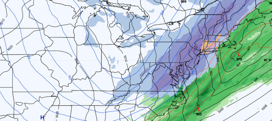
Discussion: This might be one of, if not thee, last snow storms of the season to close out Winter 2021-2022. We’re looking at two pieces of energy, one down from Canada and the other across the US from SW US. They will phase together and form a trough for the E US. Not a negative trough but enough interaction to spin up and support a deepening surface low just to the SE of NJ this Saturday.
The low intensity looks decent with most model guidance taking it sub-1000mb and some sub-990mb. Therefore we can expect some higher winds with this one, especially from the backside of it Saturday night into Sunday.
Friday (tomorrow) high temperatures should easily push into the 50s for most of NJ. Temps should then only fall to the 40s Friday night into Saturday morning as precip approaches. For this reason, this likely starts as rain Saturday morning for most of NJ. A cold front is then expected to crash through the precipitation from NW to SE between Saturday morning and early Saturday afternoon. NWNJ goes over to snow first, if not already. Then 95/CNJ and lastly SENJ.
Saturday afternoon into evening is the period where NJ can either see conversational or significant snow accumulations depending on frontogenic forcing profiles. This is the biggest piece of uncertainty with this system and why we do not have a deterministic single snow map today. The models are so far spread from this range it’s ridiculous. Outputs for NWNJ range from 3-12 inches. For SENJ, zero to 4 inches. That’s about the best that can be said for now.
All I am confident in saying is that we have a rain-to-snow situation with higher winds likely. NWNJ has the best chance for snow accums and SENJ has the least after the snow-to-rain changeover. The rain should start early Saturday morning, change to snow by noonish, and then taper off before midnight Saturday night. This is shaping up to be an interior snow event meaning NW of 95 with a much higher impact for EPA/NEPA/NWNJ. Tomorrow we’ll have a snow map out for sure.
In English: Friday looks clear and on the milder side but then Saturday should see rain break out during morning hours statewide. From mid-to-late Saturday morning, rain should change over to snow from NWNJ to SENJ as temperatures crash with a cold front. It should then snow until later Saturday night. NWNJ has the best chance for plowable/significant accumulations. SENJ has the best chance for rain ending as snow with little-to-no accumulations. The models are all over the place on this (Euro pictured above) but tomorrow we’ll have a public snow map out. Expect gusty winds with this system. Saturday night into Sunday looks very cold (teens and 20s) and then Sunday should struggle to escape the 30s statewide. This should then be it for the winter barring any thread-the-needle situation later in March. It’s now the bottom of the 9th of winter. After that, next week looks milder and that should be the trend for much of the rest of March. Have a great rest of your Thursday and please be safe! JC
Download the free Weather NJ mobile app on Apple or Android. It’s the easiest way to never miss Weather NJ content. Our premium services go even further above and beyond at the hyper-local level.
Jonathan Carr (JC) is the founder and sole operator of Weather NJ, New Jersey’s largest independent weather reporting agency. Since 2010, Jonathan has provided weather safety discussion and forecasting services for New Jersey and surrounding areas through the web and social media. Originally branded as Severe NJ Weather (before 2014), Weather NJ is proud to bring you accurate and responsible forecast discussion ahead of high-stakes weather scenarios that impact this great garden state of ours. All Weather. All New Jersey.™ Be safe! JC


LOCAL FORECAST | INTERACTIVE RADAR | LATEST NJ WEATHER ALERTS | WEDDING FORECAST| PRIVACY POLICY
© Copyright 2026 Weather NJ LLC. All Rights Reserved.
Some information that can be found on our website is provided by a private weather station and is not an officially recognized station for weather reporting. Though we always strive to achieve accurate reporting for our own use, it is important that you do NOT depend on the data provided here for any purpose.
