

Sept 1: Dorian in Beast Mode
Discussion: Per the latest (11AM) National Hurricane Center update Major Hurricane Dorian is straight up in beast mode. Dorian is a category 5 hurricane moving W at 7mph with a central pressure of 913mb. Sustained surface winds of 180mph have been clocked by flight recon o0.
There is no doubt that the N Bahamas are in for some of the strongest storm-force conditions on the planet possible…a major category 5 hurricane direct landfall hit. There’s really not much to say or do but wait until documented media finishes the story. Dorian will impact this area of the Bahamas today (Sunday) through tomorrow morning (Monday) before continuing on towards Florida.
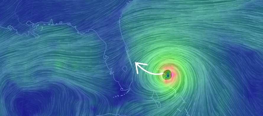
The next phase of safety hazard is for E Florida Monday PM through Tuesday PM. A few days ago models were slamming Dorian into the E Florida coast. Yesterday morning the models trended away from the Florida coast with an earlier re-curve. This morning the models have trended back closer to Florida. I told you yesterday about this…variance. It’s why you should never bear hug a model run or even entire model suite when there is so much variance in the upper-levels. Floridians should keep their guard up IMO. Models should not be taken as gospel. They are great tools but struggle, at the end of the day, to factor in every single factor of the atmosphere. Let’s use some basic meteorology instead of modelology for a minute. For example a storm that is stronger will have less influence from external steering forces. In the case of Dorian this could mean a wider turn which would likely mean landfall for E Florida. Guess what…Dorian is stronger! The surrounding cloud flow around and especially ahead of Dorian (to the W of Dorian) is all blowing towards Florida. This is typically a good indicator of steering influence.
Whether or not Dorian makes a landfall somewhere between Port St. Lucie and Cape Canaveral or stays just off the coast of Florida is irrelevant regarding the flooding rains and life-threatening storm surge that will build up on the N side of Dorian along the E Florida coast. To quote Eli Cohen from Tropical Tidbits, “a hurricane is not a dot on the map where the eye is, it’s a massive area of destructive force.” If the eye stays only 20-50 miles off the coast of Florida then the coast would still see hurricane-force winds out of the NE. That would put the coast on the W eye wall or just outside of it. You would need Dorian to pass about 50-100 miles off the coast of Florida to escape the destructive aspects of the hurricane and right now the data and live observations are not in that favor. If the E Florida landfall comes into fruition then Florida is looking at a category 3-5 hit.
After either landfall or a near graze of the E Florida coast, the next phase of safety hazard would be for coastal Georgia, South Carolina and North Carolina Wednesday and Thursday. At this point we will likely have a weakening tropical cyclone due to coastal interaction and general latitude climb against the northern hemisphere’s Coriolis Effect. Maybe Dorian gets down to a cat 2/3 at this point. But based on the suggested curvature of Dorian’s future track these cat 2/3 conditions could impact the entire SE US coast from NE Florida to OBX.
The next phase is for Delmarva and SENJ on Friday. At this point Dorian will likely be transitioning into a sub or extra-tropical cyclone as it begins to interact and form attached frontal boundaries. Regardless of how Dorian slips northward through the ridge weakness we have to watch the upper-level trough diving in on Friday. 500mb prognostication suggest that Dorian’s remnants get partially captured by this trough. Luckily the trough is progressive and not a negative-tilter. Therefore if it’s early it will lift Dorian away and out to sea even faster. If this trough slows however it would drag it closer to Delmarva/SENJ. Either way I am now prepared to put a forecast of possible heavy rain, moderate winds and minor coastal flooding on the table for Delmarva and SENJ this upcoming Friday (Sept 6).
Once Dorian clears the Mid-Atlantic US and moves out to sea I would expect the best weather of the year. Timing could change around but right now this would mean Saturday and maybe Sunday (Sept 7-8). The N flow behind the storm would bring cooler and drier air S out of Canada which would be reinforced by the front-side of westward approaching high pressure. Basically the storms system takes away the moisture with it and we’re left with mostly sunny skies with a crisp feel.
Looking upstream in the tropics we’ve now got a solid wave departing the ~Cape Verde region. Some of the dry air from the Sahara Desert has relaxed and its go time for the Atlantic Ocean hurricane basin.
In English: The N Bahamas are in trouble today and tomorrow from a category 5 direct hit from a major hurricane. E Florida still has a range of possibilities for Monday night through Tuesday including anything from a landfall to a graze by a cat 3-5 major hurricane. I still feel that landfall would be between Port St. Lucie and Cape Canaveral if such occurs. Otherwise Dorian would still pass E FL close-enough to cause a lot of coastal damage and flooding rains. Coastal Georgia, South Carolina and North Carolina could see cat 2/3 conditions Wednesday and Thursday. The chances of Dorian’s remnants grazing Delmarva and SENJ on Friday are now increasing. This would be decent SENJ impact but likely manageable (like a weak-to-moderate nor’easter but fast-moving – no stall or retrograde). The most beautiful weather of the year would likely ensue behind Dorian’s departure, for the weekend, as humidity is lifted away with it. This is how it all looks to me at this point. Please be safe! JC
Download the new free Weather NJ mobile app on Apple and/or Android. It’s the easiest way to never miss Weather NJ content. Our premium services go even further above and beyond at the hyper-local level. Looking for industrial-caliber long-range forecasting data that I personally recommend? Check out WeatherTrends360!
Jonathan Carr (JC) is the founder and sole operator of Weather NJ, New Jersey’s largest independent weather reporting agency. Since 2010, Jonathan has provided weather safety discussion and forecasting services for New Jersey and surrounding areas through the web and social media. Originally branded as Severe NJ Weather (before 2014), Weather NJ is proud to bring you accurate and responsible forecast discussion ahead of high-stakes weather scenarios that impact this great garden state of ours. All Weather. All New Jersey.™ Be safe! JC


LOCAL FORECAST | INTERACTIVE RADAR | LATEST NJ WEATHER ALERTS | WEDDING FORECAST| PRIVACY POLICY
© Copyright 2026 Weather NJ LLC. All Rights Reserved.
Some information that can be found on our website is provided by a private weather station and is not an officially recognized station for weather reporting. Though we always strive to achieve accurate reporting for our own use, it is important that you do NOT depend on the data provided here for any purpose.
