

Sept 11: Florence to Spare New Jersey
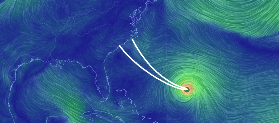
Discussion: I’ve seen enough to remove the landfall potential for New Jersey and likely even Delmarva. I’m 90%-plus confident that landfall will occur between the SC/NC border and Cape Lookout, NC (the track indicated in the above cover image). I think Cape Hatteras, NC is the furthest N possible landfall but even that is becoming unlikely. There is still room for landfall to trend southward IMO. But not northward. Secondary storm-diameter effects could still span from Charleston, SC to Virginia Beach, VA. While New Jersey experiences relief from this news, please be considerate of those who will be taking the direct hit from a major hurricane (cat 3+) this Thursday night. This could be their Katrina/Sandy/etc.
Florence is still a major category 4 hurricane as of the latest 2pm National Hurricane Center update. Sustained winds have dropped from 140mph to 130mph due to the completion of an an Eye Wall Replacement Cycle (EWRC). You’ll now see a bigger eye with likely a more-expansive diameter of overall circulation. This is why areas outside of the expected landfall (as far S as Charleston, SC and as far N as Virginia Beach) still need to keep their guard up for a rain & wind event. Category 5 achievement is not off the table prior to landfall.
After the Thursday night landfall, there’s a super small chance of some very fringe/outer-band rainfall Friday and Saturday, primarily for SNJ. I’ll give this a 20% chance. Otherwise Friday and Saturday have an 80% chance to stay dry. Winds should be noticeable off the ocean but tolerable and manageable for outdoor interests. Gusts should be most felt along the immediate coast and less felt away from the ocean. I do still have some concern for coastal flooding given the prolonged period of onshore flow that could set up from Thursday through early next week. I’d say the Delaware Bay coasts and Cape May Peninsula have the best chance to deal with coastal flooding. Given the further S expected landfall, we lose the tremendous eye wall surge aspect but again, I still don’t know how the prolonged duration of onshore flow will weigh in. My best guess at this point is minor-to-moderate levels.
Sunday through Tuesday could be wet if Florence’s remnants lift out and curve over New Jersey. In that case we are talking about a run-of-mill rainy windstorm for most of New Jersey with possibly some enhanced coastal flooding.
English: Thanks for your patience and understanding since the beginning of Florence’s tracking. I only feel confident in taking a Delmarva/NJ landfall off the table today. The southern Mid-Atlantic US however (Myrtle Beach, SC to Cape Hatteras, NC) is in for a rough time this Thursday night/Friday morning and especially the period of recovery to follow. Therefore the rest of this week for New Jersey should continue being crappy (clouds, rain, thunderstorms, breaks of humid sunshine, etc.) through Thursday evening. I’ll point out any thunderstorm developments on radar. More slow-moving rain is expected tonight so watch out for flash flooding from such. But from Friday morning through the weekend, we should dry out with the developing onshore flow and high pressure influence. This might keep us cloudier than desired at times this weekend but free from catastrophe. NNJ and CNJ have the best chance to stay dry with sunny breaks. As I mentioned above in the discussion, just a super small chance that some outer band tips from Florence produce light precipitation in SNJ, especially extreme SNJ. With any luck all of NJ stays completely dry. Winds should be stiff off the ocean all weekend which maintains the concern for minor-to-moderate coastal flooding. You should feel the winds most along the coast with less away from the ocean. Lastly, Florence could still bring s run-of-mill rainstorm in the Sunday to Tuesday period (mainly Monday). Let’s revisit that in a few days once confidence can grow re: post-Florence landfall. Have a great day and please be safe! JC
Jonathan Carr (JC) is the founder and sole operator of Weather NJ, New Jersey’s largest independent weather reporting agency. Since 2010, Jonathan has provided weather safety discussion and forecasting services for New Jersey and surrounding areas through the web and social media. Originally branded as Severe NJ Weather (before 2014), Weather NJ is proud to bring you accurate and responsible forecast discussion ahead of high-stakes weather scenarios that impact this great garden state of ours. All Weather. All New Jersey.™ Be safe! JC


LOCAL FORECAST | INTERACTIVE RADAR | LATEST NJ WEATHER ALERTS | WEDDING FORECAST| PRIVACY POLICY
© Copyright 2026 Weather NJ LLC. All Rights Reserved.
Some information that can be found on our website is provided by a private weather station and is not an officially recognized station for weather reporting. Though we always strive to achieve accurate reporting for our own use, it is important that you do NOT depend on the data provided here for any purpose.
