

Sept 11: Rain and Storms Approaching the Region
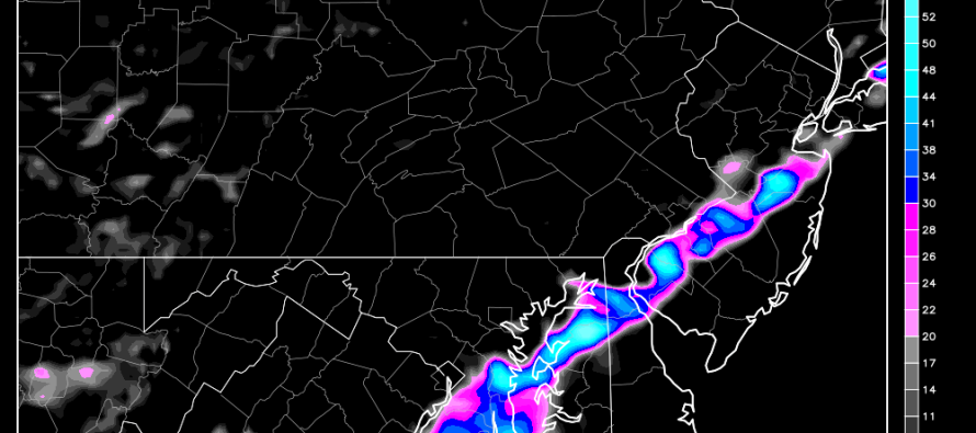
The cold front has made it into western PA and will advance through our region this afternoon into evening. By tomorrow morning, the front should be out into the Atlantic Ocean with cooler and drier temperatures left in its wake. As far as timing goes, whatever happens should happen between late afternoon in NWNJ and about 10PM in SENJ. During this time period precipitation ahead of the cold front should fall as gusty showers with little to no severe critieria. Instability is lacking and wind shear is barely marginal which is why the NWS SPC has removed the elevated risk for severe weather. Here’s a radar shot showing the current cold front location and associated precipitation starting to form ahead of it:
There is a lot of cloud cover ahead of this cold front today. We call it cloud debris. That will prevent the sun from diurnally heating the surface—robbing thunderstorms of the energy they need to develop. We also have weak wind shear (change in wind direction over change in altitude) which means even if the higher winds are brought down to the surface, they would still likely fail to meet severe critieria (wind gusts > 58mph). The only favorable aspects for storm development are the enhanced lower level jet and cold front trigger. This setup leads to weak nuisance rain and storms 9 times out of 10 which is why I think just gusty showers is the most likely scenario.
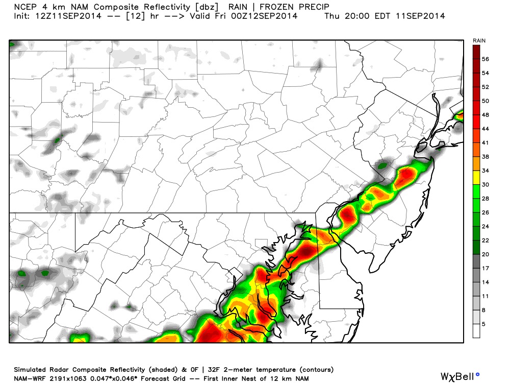
Let’s look at some guidance. The high-resolution 12Z 4km NAM shows a line segment of precipitation moving over the I-95 corridor around 7PM. That means it would first hit NWNJ around 5PM and clear SNJ by 10PM. This model shows expected precipitation intensity at ~6PM:
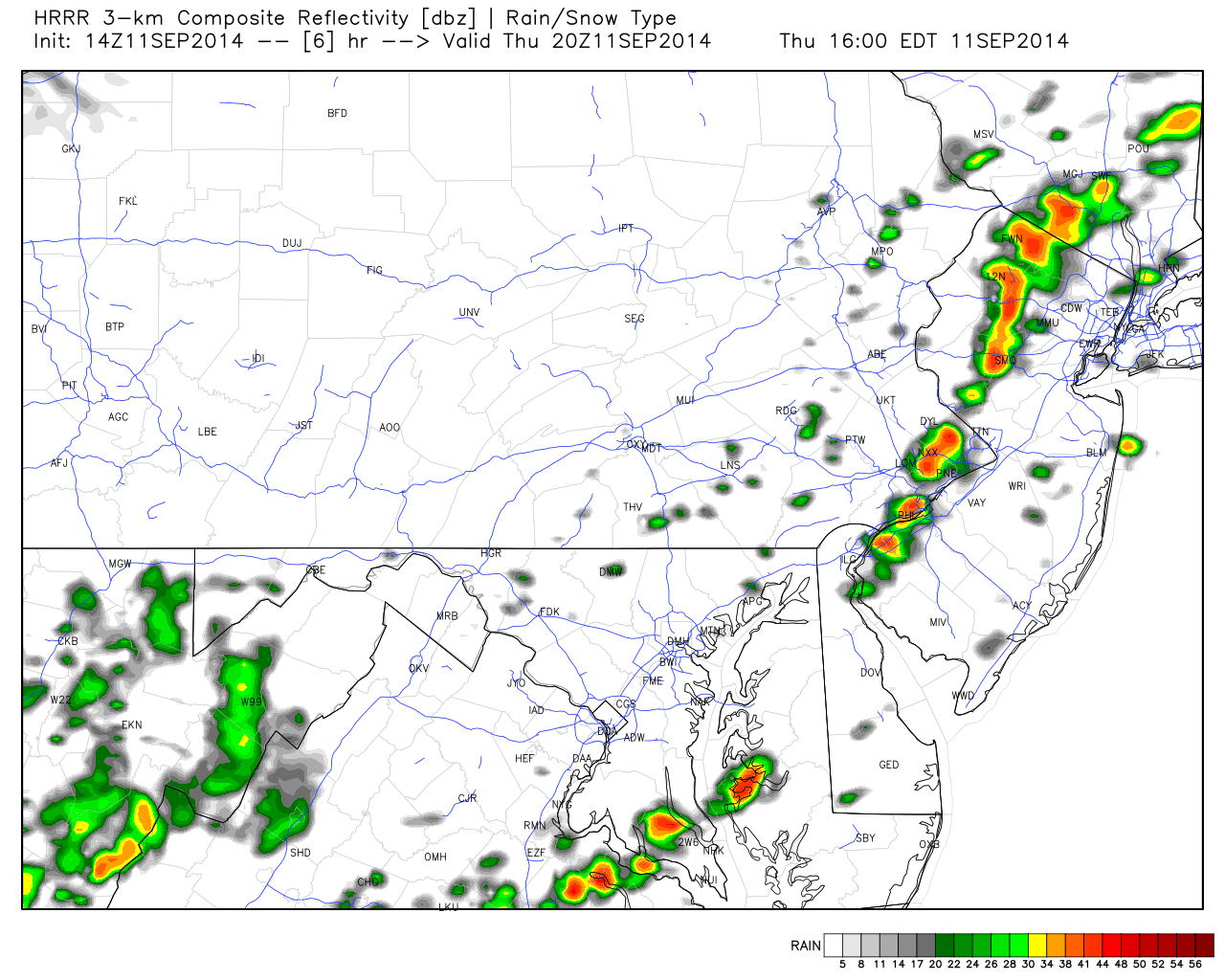
The 14Z HRRR shows an earlier schedule with precipitation breaking out mid-afternoon and clearing the coast as early as sunset. I like a blend of both models for timing. This model image shows expected precipitation intensity around 3PM:
In English: Expect a warmer day today with a mixed bag of mostly clouds and sun. Rain showers and possibly weak thunderstorms will move through the region from NWNJ to SENJ between afternoon and evening. Anything from breezy drizzle to gusty downpours with a few rumbles is possible. Areas stuck under heavy downpour could deal with flash flooding. The bottom line…it’s nuisance stuff with little to no severe risk. If a few gusts trigger a warning…so be it but its not likely. Everything should be cleared through by midnight dropping temperatures and humidity levels for tomorrow. Be safe! JC
Jonathan Carr (JC) is the founder and sole operator of Weather NJ, New Jersey’s largest independent weather reporting agency. Since 2010, Jonathan has provided weather safety discussion and forecasting services for New Jersey and surrounding areas through the web and social media. Originally branded as Severe NJ Weather (before 2014), Weather NJ is proud to bring you accurate and responsible forecast discussion ahead of high-stakes weather scenarios that impact this great garden state of ours. All Weather. All New Jersey.™ Be safe! JC


LOCAL FORECAST | INTERACTIVE RADAR | LATEST NJ WEATHER ALERTS | WEDDING FORECAST| PRIVACY POLICY
© Copyright 2026 Weather NJ LLC. All Rights Reserved.
Some information that can be found on our website is provided by a private weather station and is not an officially recognized station for weather reporting. Though we always strive to achieve accurate reporting for our own use, it is important that you do NOT depend on the data provided here for any purpose.
