

Sept 18: Watching Hurricane Maria Closely
Discussion: Let’s address the immediate issues with Jose real quick. Jose is currently crossing the 35N latitude (same latitude as OBX). From this point and northward, Jose is will pass over colder water which will finish the extra-tropical transition process (already almost complete). This means that Jose is loosing his tightly-wound higher winds around his core and now winds will spread throughout the entire diameter of the system. Jose will basically become like a nor’easter. I now expect Jose to pass over 300 miles off the Jersey Shore which means most outer-fringe rain could under-perform for Jersey, even on the coast. With that said, I expect more of a raw drizzle with some occasional downpours rather than all downpour tomorrow. Sustained winds of 20-30mph with a few gusts to 40mph are the conditions I expect on the coast. Areas away from the ocean will likely say “what storm?” aside from a few NE gusts. The further passage out to sea has favorable coastal flooding impacts as well. I still expect minor-to-moderate coastal flooding tomorrow, especially during both high tides, but I do not see a catastrophic coastal flooding situation. Those who normally flood with run-of-mill coastal storms and nor’easters will likely see the norm. The National Hurricane Center has dropped all Tropical Storm Watches on the Jersey Shore associated with Jose and on he will go. Take the humidity. Leave the sunshine.
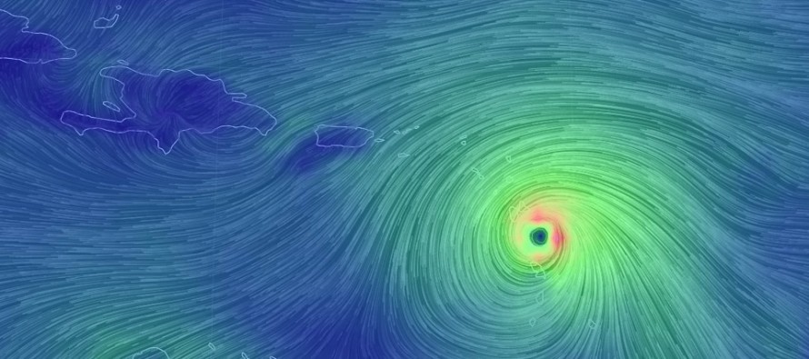
Now let’s talk about Maria. Currently, Maria is a category 5 major hurricane about to hit (tonight) the Lesser Antilles, specifically the area including Guadeloupe, Dominica, Marinique, St. Lucia, Barbados and the Grenadines. Next on deck will be Anguilla, the British Virgin Island and Puerto Rico tomorrow into Wednesday. I do not expect much weakening so all areas mentioned so far are subject to major hurricane (possibly category 5) damage. By Thursday, Maria should be near/just N of Hispaniola about to enter the Bahamas for Friday and Saturday. A catastrophic scenario is unfolding for many areas just hit by Irma. Our deepest thoughts and concerns are with all in Maria’s immediate path. The latest NHC 8PM update reflects all of these observations:
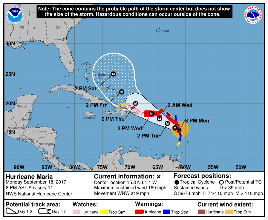
Maria’s track beyond the Bahamas is still relatively speculative. Believe it or not, Jose’s remnants will have a major impact on Maria’s steering. Once Jose brings us our routine coastal storm/nor’easter-like conditions tomorrow, he will pull away from New Jersey but have nowhere to go due to a blocking ridge to his N/NE. Therefore Jose’s upper-level remnant energy could have a tugging force on Maria. So here are our possible scenarios:
1) Jose fizzles out quicker/pulls away from east coast completely: This would mean little tugging influence on Maria and therefore the east coast would expect a direct hit somewhere in the GA/SC/NC coast.
2) Jose sticks around and weakens the ridge: This would mean that Jose’s remnant upper-level energy would pull Maria out to sea on a track like Jose’s possibly even a quicker departure once N of the 35N latitude.
3) A hybrid mix: This would be the worst case scenario. If Jose weakens some but not fully…and the ridge remains strong…then Maria could split the difference, graze OBX before slamming into the Delmarva/NJ/NYC area.
So what we want to see is for Jose to remain as strong as possible so he can pull Maria away from the east coast through the ridge weakness. What we do not want to see is for Jose to depart quickly and/or fizzle out quickly. That’s pretty much what its coming down to and I will not know anything further until I see what Jose does after passing out coast out to sea. It might be Friday until I’m at the point to make that decision. We have a lot of time so please do not panic. The only action you should take at this point is developing a hurricane safety plan which you should have 24/7/365 anyway, especially if living near the coast. You wouldn’t have to start exercising this plan until September 23-24th if Maria still looks like an east coast threat at that time. If Maria is going to hit the NJ area, it would not be until the Sept 26-28th period. Let’s see how live observations and model guidance continues to evolve.
In the meantime, Eastern PA Weather Authority Meteorologist Bobby Martrich and myself will be discussing deep technical model analysis in our My Pocket Meteorologist Premium Forum (bottom option). Our conversations in this forum provide even more of a technical discussion than this article including the conclusive insight that helps ultimately drive these articles. While you’re there, have a peek at our other premium products such as our hyper-local text notification system for daily forecasts and severe weather. Thousands of people have signed up for these products and thoroughly enjoy them, especially during the winter months. Not to worry, my free services (daily articles and outlooks) will always remain free as-is. These premium services are mostly for business owners and weather nerds/freaks like me who absolutely have to know the latest info as soon as we learn of it.
In English: Jose is for the most part a miss. Immediate coastal regions should experience run-of-mill coastal storm/nor’easter-like conditions tonight through Wednesday morning but that’s about it. Areas away from the ocean will likely see nuisance conditions for the most part. Maria is about to catastrophically hit parts of the Lesser Antilles tonight into tomorrow morning and likely Puerto Rico tomorrow into Wednesday. By Friday, Maria should be approaching the Bahamas and that’s when I’ll have a much more certain expectation as to whether Maria will make landfall on the east coast or not. Until then there is no reason to panic, only reason to monitor a “potential threat” 8-10 days from now. Have a great night and please be safe! JC
Jonathan Carr (JC) is the founder and sole operator of Weather NJ, New Jersey’s largest independent weather reporting agency. Since 2010, Jonathan has provided weather safety and forecasting services for New Jersey and immediate surrounding areas through the web and social media. Originally branded as Severe NJ Weather (before 2014), Weather NJ is proud to bring you accurate and responsible discussions ahead of high-stakes weather scenarios that impact the garden state. All Weather. All New Jersey.™


LOCAL FORECAST | INTERACTIVE RADAR | LATEST NJ WEATHER ALERTS | WEDDING FORECAST| PRIVACY POLICY
© Copyright 2024 Weather NJ LLC. All Rights Reserved.
Some information that can be found on our website is provided by a private weather station and is not an officially recognized station for weather reporting. Though we always strive to achieve accurate reporting for our own use, it is important that you do NOT depend on the data provided here for any purpose.
