

Sept 2: Dorian to Impact Entire US East Coast
Discussion: Per the latest (8AM) National Hurricane Center update Dorian is a category 5 hurricane still moving W at 1mph with a central pressure of 916mb.

Dorian hit the N part of Abaco yesterday and has stalled over Grand Bahama all as a category 5 hurricane. These flat islands have caused just enough friction to weaken Dorian some along with an attempted Eye Wall Replacement Cycle (EWRC). Make no mistake it is still a dangerous tropical cyclone. Whether a weak or strong cat 5 there is really little difference in terms of destruction. You’ve probably seen media from the N Bahamas yesterday and you’ll see more in the coming days. A very sad situation.
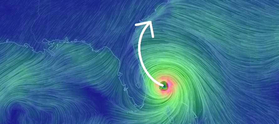
All eyes now turn to E Florida impacts. Dorian has continued to track a little S of all model guidance before making the northward turn. The northward turn is going to happen. It HAS to happen soon put it that way. But we still do not know if it will be in time for E Florida to escape the most destructive wind force of the storm system…the eye wall. Because of the stronger-than-modeled nature of the storm the backside has been pumping the ridge to the NW. This ridge is the force that pushed Dorian to the W after making the turn N of Puerto Rico. Therefore it’s been a symbiotic relationship of maintaining the force that pushed it W. That force has finally eroded and Dorian will now make the turn into the weakness between the ridges.
Central and northern E Florida is in for a rough period starting later today and lasting through tomorrow possibly into Wednesday. It is around this time of a hurricane’s life cycle that the wind fields expand especially the most destructive eye wall winds after the attempted EWRC. This is significant because even if Dorian’s eye center stays 30-60 miles off the coast of Florida the W side of the eye wall would still impact the E Florida coast. We need Dorian to stay about 75-100 miles offshore and right now live observations are struggling to suggest so.
Technically for a landfall to be called the center of the eye must pass over land. This means you could have the E FL coast just inside the eye but no called landfall. These are stupid semantics if you ask me. E Florida should still be prepared for the worst (official landfall) but hope for the best (75-100 miles offshore). The life-threatening storm surge and flooding rains are likely going to affect everyone from Port St; Lucie and northward with a strong chance of at least hurricane force winds between this evening and Wednesday AM. If you are in an evacuation zone please consider listening to the authorities who issued such. I feel like the slow-moving nature of this storm is the most underestimated aspect especially with most people focused on the eye only. Again…a hurricane is not just a dot. It’s a very large complex system of destructive force with duration often overlooked.
After Florida Dorian is now expected to ride the entire SE US and Mid-Atlantic US coast through coastal Georgia, South Carolina, North Carolina (OBX) as the system weakens from a major hurricane to a weaker category 1 hurricane. I don’t think I’ve ever seen a hurricane able to touch so much of the east coast. Dorian should impact Georgia, South Carolina and North Carolina from Wednesday PM to Friday AM.
The final area of concern is the Delmarva Peninsula and New Jersey for Friday. This has not changed since my discussion yesterday. Therefore I expect heavy rains, moderate winds (sustained 20-40mph with gusts to 60+mph) and minor-to-moderate coastal flooding on Friday for Delmarva, and SENJ. Any impacts NW of the I-95 corridor would be limited to rain and lesser winds only. At this point (latitude) Dorian will be transitioning to a post-tropical cyclone with attached frontal boundaries and a wide expansion of the remaining wind field. After New Jersey impacts on Friday some of the best weather ever should follow for the weekend as Dorian wraps up into a mid-latitude extra-tropical monster for coastal New England and SE Canada. Amazing to think that a storm system can wreak so much havoc from Florida to Maine.
In English: The N Bahamas have been hit really hard and will continue to get hit through today. The E FL coast (from Port St. Lucie and northward) should be hit from later tonight through Wednesday. The range of E FL possibilities still range from landfall to just offshore. Either scenario is an evacuation scenario for the storm surge and heavy rainfall that will have no place to drain. The remaining wildcard is whether or not the E FL coast will experience weak hurricane force winds or major hurricane force winds depending on how close the center of Dorian drifts W before turning N. There is still a lot of uncertainty about this which is why you should still prepare for the worst and hope for the best. That’s the most confident thing I can say at this point. Cape Canaveral jets out the furthest E on the Florida coast so that would have the best chance of the worst impacts. Dorian will then ride the entire SE US coast (just offshore) through Georgia, South Carolina and North Carolina Wednesday PM through Friday morning. OBX could actually see a possible landfall late Thursday night/early Friday morning from a cat 1-3 hurricane. Dorian should then bring heavy rain, moderate winds and coastal flooding to Delmarva and SENJ/ENJ on Friday. Amazing weather would then follow for New Jersey from Saturday into early next week. Amazing because Dorian will carry all the region’s moisture (humidity) away with it as cool/dry N/NW flow ensues. Everyone please enjoy the rest of your Labor Day and be safe! JC
Download the new free Weather NJ mobile app on Apple and/or Android. It’s the easiest way to never miss Weather NJ content. Our premium services go even further above and beyond at the hyper-local level. Looking for industrial-caliber long-range forecasting data that I personally recommend? Check out WeatherTrends360!
Jonathan Carr (JC) is the founder and sole operator of Weather NJ, New Jersey’s largest independent weather reporting agency. Since 2010, Jonathan has provided weather safety discussion and forecasting services for New Jersey and surrounding areas through the web and social media. Originally branded as Severe NJ Weather (before 2014), Weather NJ is proud to bring you accurate and responsible forecast discussion ahead of high-stakes weather scenarios that impact this great garden state of ours. All Weather. All New Jersey.™ Be safe! JC


LOCAL FORECAST | INTERACTIVE RADAR | LATEST NJ WEATHER ALERTS | WEDDING FORECAST| PRIVACY POLICY
© Copyright 2026 Weather NJ LLC. All Rights Reserved.
Some information that can be found on our website is provided by a private weather station and is not an officially recognized station for weather reporting. Though we always strive to achieve accurate reporting for our own use, it is important that you do NOT depend on the data provided here for any purpose.
