

Sept 20: Updated Forecast for Hobie 16 Championships

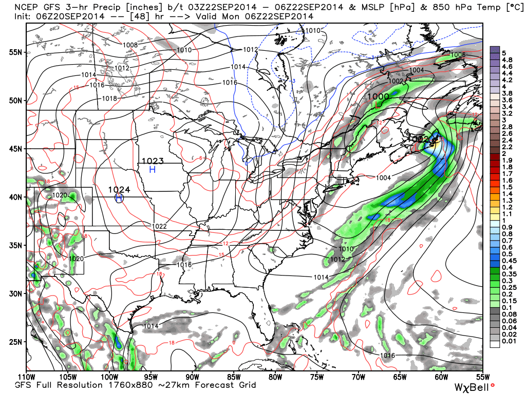
An area of low pressure will be sliding up the coast but well offshore between today and tomorrow. The only threat that existed for rain now looks to happen early Monday morning. As of now it looks like this threat, of just light showers, will be well out to sea come race time. For the most part, it looks like a dry frontal passage. The Appalachian Mountains should starve the frontal boundary of nearly all its moisture by the time it reaches the Delaware Bay region. Here’s the most recent GFS showing the front already out to sea at 2AM Monday morning:
We’re close enough now for an initial daily forecast throughout the race days. I’ll be updating daily at this point with synoptic discussion the night before and hourly conditions the morning of. Night-before forecasts will be posted by 9PM and morning-of hourly forecasts will be posted by 7AM:
Sunday will be the last day of a mini-warm streak. Highs should reach the lower-80s with a 5-10mph S/SW breeze, thanks to lifting ahead of the pre-frontal trough. Can’t rule out a morning shower before skies give way to sun.
Monday will be noticeably cooler with the front having passed through overnight. Again, all showers are expected to be well out to sea by sunrise. Highs should only reach the lower-to-mid 70s with gusty NW winds. Skies should be partly cloudy. The low pressure system mentioned beforehand will phase with the pre-frontal trough over Nova Scotia and place the Delaware Bay region on the southwestern side of cyclonic flow. With that being said, expect 10-15mph NW winds with gusts to 25mph. I wouldn’t be surprised if a few gusts hit 30mph.
Tuesday will be very similar to Monday but with reduced winds. Highs should reach the lower-70s with sustained NW winds of 5-10mph with gusts to 15mph. Skies should be mostly sunny.
Wednesday looks very pleasant with mostly sunny skies and high temperatures in the low-70s. Expect a wind shift as high pressure settles over northern NJ/NY State. This will place the Delaware Bay region on the southern side of anti-cyclonic flow which means onshore winds. At this point it looks like sustained 10mph E/NE winds with gusts to 20mph.
Thursday and Friday look like carbon copies of Wednesday with high pressure in full control to our north. Temperatures will peak in the lower-to-mid 70s with E/NE onshore flow (5-10mph with gusts to 15/20mph). Skies should remain mostly sunny. A low pressure system will be passing by but it is currently modeled to miss out to sea.
As long as there are no major changes, the next forecast will be posted tomorrow (Sunday) evening. Be safe and have a great day! JC
Jonathan Carr (JC) is the founder and sole operator of Weather NJ, New Jersey’s largest independent weather reporting agency. Since 2010, Jonathan has provided weather safety discussion and forecasting services for New Jersey and surrounding areas through the web and social media. Originally branded as Severe NJ Weather (before 2014), Weather NJ is proud to bring you accurate and responsible forecast discussion ahead of high-stakes weather scenarios that impact this great garden state of ours. All Weather. All New Jersey.™ Be safe! JC


LOCAL FORECAST | INTERACTIVE RADAR | LATEST NJ WEATHER ALERTS | WEDDING FORECAST| PRIVACY POLICY
© Copyright 2026 Weather NJ LLC. All Rights Reserved.
Some information that can be found on our website is provided by a private weather station and is not an officially recognized station for weather reporting. Though we always strive to achieve accurate reporting for our own use, it is important that you do NOT depend on the data provided here for any purpose.
