

Sept 2019 WeatherTrends360 Outlook

It’s time to harness WeatherTrends360 technology and look at how the rest of September 2019 should play out. WeatherTrends360 algorithms are documented with an 84% verification rate and are based on oceanic water cycles, time table series and very complex mathematics. The best takeaway from this data are general trends (cool vs warm, rainy vs dry, etc). I’m always hesitant to forecast specific surface conditions (rainfall amounts, snowfall amounts, winds, etc) beyond the 7 -day forecasting period. But temperature and precipitation trends are what WeatherTrends360 does best with their proprietary mathematical analysis derived from over 150 years of reactive pattern data. For this reason, let’s call this a long-range discussion of reasonable expectations rather than a locked-in long-range forecast.

The following diagram is calculated using WeatherTrends360 proprietary algorithms for New Jersey in general. Please keep in mind that micro-climate influences can vary. NWNJ elevations and immediate coastal areas, for example, will likely verify slightly cooler than illustrated due to elevation and marine flow influence. Interior CNJ/SNJ (closer to Philly/Trenton – I-95 corridor) slightly warmer than illustrated. All areas of NJ however would have similar graph trends and sky conditions. It’s best to let the graph paint an overall picture (trends) instead of focusing on the details.
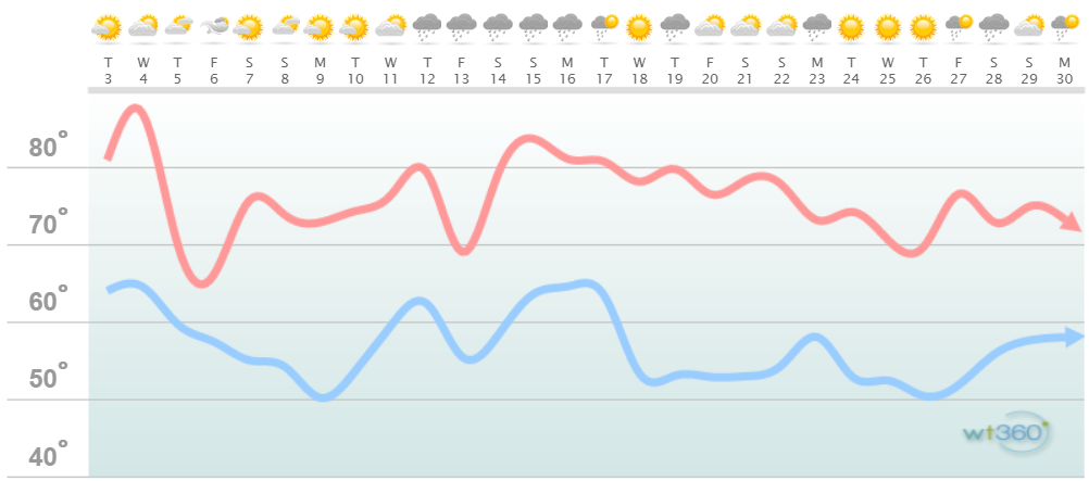
Discussion: The immediate spike and dip is fairly obvious surrounding the weak departing ridge and approaching strong trough that will wrap in and behind Dorian’s departure. Wednesday (tomorrow) daytime hours are when the warm sector peaks. A cold front kicks off the cooler weather tomorrow night (Wednesday night) and then the N flow behind Dorian re-enforces such. The only reason Saturday gets as warm as advertised is likely because of the overly-dry air. Temps spike higher in dry air than in humid conditions. Go figure but it’s science!
We then warm up towards the middle of the month with a rainy stretch of weather. This coincides with another ridge which actually concerns me a bit. The tropics have really come alive recently and an E US ridge is a bad thing to have in place should any tropical systems approach. There are already a few fantasy-range hurricanes showing on the models. From this range, hence fantasy-range, it’s futile to consider specific impacts. But the overall trend is that something might try to happen in the Sept 15-20 period. Let’s cautiously and responsibly approach. After that well likely see our last day in the 80s for the rest of September.
Overnight lows should still fall into the 60s here and there through the first half of September. The second half of September will feature overnight lows down into the 50s for most areas of NJ. Only the immediate coastal regions will likely hang warmer due to ocean temperatures still being above 70. And then we enter nor’easter season in October with highs in the 60s/70s and lows in the 40s/50s becoming common.

In English: The first half of September looks spiky temperature wise (from warm to cool and then from cool to warm). The second half of September looks a bit more consistent with a slow natural decline of seasonal temperatures. The first-third and last-third of the month look drier than the middle-third of the month precipitation-wise. It’s peak hurricane season so I’m watching anything that forms…especially int he Sept 15-20 period when a strong E US ridge is anticipated. Everyone have a great September and please be safe! JC
Jonathan Carr (JC) is the founder and sole operator of Weather NJ, New Jersey’s largest independent weather reporting agency. Since 2010, Jonathan has provided weather safety discussion and forecasting services for New Jersey and surrounding areas through the web and social media. Originally branded as Severe NJ Weather (before 2014), Weather NJ is proud to bring you accurate and responsible forecast discussion ahead of high-stakes weather scenarios that impact this great garden state of ours. All Weather. All New Jersey.™ Be safe! JC


LOCAL FORECAST | INTERACTIVE RADAR | LATEST NJ WEATHER ALERTS | WEDDING FORECAST| PRIVACY POLICY
© Copyright 2026 Weather NJ LLC. All Rights Reserved.
Some information that can be found on our website is provided by a private weather station and is not an officially recognized station for weather reporting. Though we always strive to achieve accurate reporting for our own use, it is important that you do NOT depend on the data provided here for any purpose.
